Charleroi Metro Map

Logo Metro BrusselsThe Metro is located in Charleroi Belgium

This is not really considered a meter, but rather as part of the country's rail system. It was inaugurated on 21 June 1976, currently 20 Tube stations along 17,5 Km (10,9 Miles), equivalent to a station each 875 meters (956,9 Yards).

To enlarge the images, you have to click above.

Charleroi metro mapCharleroi Metro Map Charleroi Metro Map

Links:

Map of Brussels Subway

Logo Metro BrusselsThe Brussels Metro (officially is called as “Metro de Bruxelles”, or also “Brusselse metro”) is in Belgium.

It was extended with new stations in the year 2009, currently 61 Tube stations along 49,9 Km (31 Miles), ie, each station there 818 meters (894,6 Yards).

To view the larger map Metro Brussels, click above image.

Brussels subway map

PDF version of the map: Brussels Metro Map (Brussels).pdf


RECOMMENDATION: On the web TicketBar, You can buy tickets in advance Amusement, museums, monuments, and other interesting things about the city of Brussels. Sometimes, Some tickets are sold at a discount of up to 20%.


Links:

Map subway of Minsk

Logo metro MinskFrom Metro Minsk (officially called “Minsk Metro”) is in Belarus.

The latest extension of this meter known, was made in the year 2012, currently 28 Tube stations along 35,4 Km (22 Miles), which is to have on average each station 1264,3 meters (1382,6 Yards).

Click on the map below Minsk Metro, to view larger map.

Mapa metro MinskMap in PDF format: Metro Map Minsk.pdf

Links:

Metro de Bakú

Logo of Baku Metro

El Metro de Bakú, officially known as “Bakı Metropoliteni”, es el sistema de transporte subterráneo de la capital de Azerbaiyán.

Inaugurated on 6 November 1967, este sistema ha crecido y se ha expandido a lo largo de los años, with its latest expansion in 2022.

At the moment, has 3 lines that cover 27 stations along 40.3 kilometres (about 25.04 miles). Es crucial para la movilidad diaria de los residentes y visitantes en Bakú.

Schedules

El Metro de Bakú opera con los siguientes horarios:

  • Every day: of 6:00h a 0:00h.

Rates

El sistema ofrece una tarifa asequible para los pasajeros (year 2024):

  • One-way ticket: 0.30 AZN (~0.18 USD) for a single trip.

Official Web site

For more information, visit the sitio oficial del Metro de Bakú.
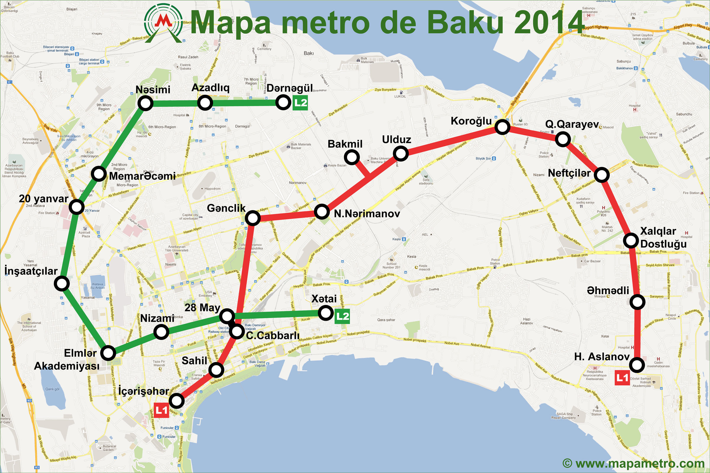
Metro Map

A continuación le mostramos el mapa del Metro de Bakú:

Mapa metro Baku

PDF version of the map: Map Metro Baku.pdf

History of the subway

El Metro de Bakú, inaugurated on 6 November 1967, es un símbolo de la modernización de la ciudad.

Inspirado en los sistemas de metro soviéticos, comenzó con una línea de 9.2 kilómetros y cinco estaciones: Baki Soveti (ahora Icheri Sheher), Sahil, 28 Aprel (hoy 28 May), Ganjlik y Nariman Narimanov. La red fue ampliada gradualmente con líneas adicionales que conectaron más áreas urbanas y suburbanas.

La segunda línea, construida entre las décadas de los 70 y 80, añadió estaciones importantes como Nizami y Memar Ajami.

Durante los años 90, las estaciones cambiaron de nombre para reflejar el período post-soviético, y el sistema se expandió a través de la línea púrpura y otras nuevas estaciones, as Koroğlu, 8 Noyabr y Avtovagzal​ (Wikipedia)​​ (MetroGovAz)​.

Historia del mapa del metro de Bakú

El mapa del metro ha evolucionado a lo largo de los años para reflejar las expansiones de la red y la renovación de las estaciones.

La versión actual fue diseñada por Ramin Həsənəlizadə en 2015, quien identificó las dificultades que tenían los viajeros para navegar el sistema. Creó una nueva versión que aclaraba los trayectos y rutas en los diferentes sentidos, asegurando que la información fuera clara para los pasajeros, incluyendo turistas.

Este nuevo diseño facilita la comprensión del sistema, indicando claramente las tres líneas: roja, verde y púrpura​.

Additional data

El metro de Bakú ofrece un acceso directo a muchos de los destinos más importantes de la ciudad, conectando sus estaciones con atracciones turísticas y culturales, as:

  • Bulevar de Bakú (Estación Sahil): Paseo marítimo popular con restaurantes, tiendas y entretenimiento.
  • Torre de la Doncella (Estación Icheri Sheher): Patrimonio histórico en el casco antiguo de Bakú.
  • Centro Heydar Aliyev (Estación Nariman Narimanov): Edificio icónico de arquitectura contemporánea.

Otras estaciones, as 28 May y Ganjlik, también reflejan la rica historia y cultura de la ciudad, incorporando un diseño que mezcla motivos soviéticos y azerbaiyanos​ (UrbanRail)​.

Sydney Metro Area (Australia)

Logo metro SidneyThe Metro is located in Sydney Australia.

This is not really considered a meter, but rather as part of the railroad system of the country. He was inaugurated on 20 December 1926 and currently has 14 Metro stations, along 22,1 Km (13,7 Miles), which is equivalent to having each station 1578,6 Meters (1726,3 Yards).

To make large map of Sydney Metro, click above for the next picture.

Sydney Metro Area

Version of the map in PDF format: Metro Map Sídney.pdf

Links:

Subway Map of Buenos Aires

logo Buenos Aires metro, ArgentinaThe meter is located in Buenos Aires Argentina.

It was expanded last year 2011, currently 82 Metro stations, along 49,3 Km (30,6 Miles), which is equivalent to having a station on average each 601,2 meters (657,5 Yards).

Click on the image to enlarge:

Subway Map of Buenos Aires, Argentina Version of the map in PDF format:
Metro Map of Buenos Aires.pdf

Links:

Map of Algiers metro (Algiers Metro)

Logo of the Algiers MetroIntroducing the Metro map of Algiers. The Algiers metro (officially is called as “Algiers Metro”) you are in a country called Algeria.

Was expanded last year 2011, currently 10 Metro stations, along 9,2 Km (5,7 Miles), ie, each station there 920 Meters (1006,1 Yards).

Click on the image to make it larger:

Map of Algiers metro

Version of the map in PDF format: Algiers Metro Map (Algiers).pdf

Links:

Subway maps worldwide