Sydney Metro (officially called “Sydney Metro”) is Australia's first fully automated, driverless metro system, and represents the largest urban transportation infrastructure project in the country.
Inaugurated on 26 May 2019, The metro currently has 13 stations and a line that covers 36 kilometres (22.4 miles). The system is expanding rapidly, and it is expected that for 2024 include new extensions under Sydney Harbor and to the southwest, with a total of 31 stations and 66 kilometers of roads.
subway map
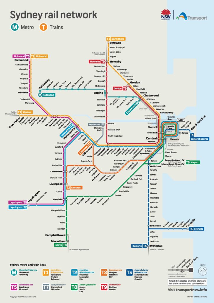
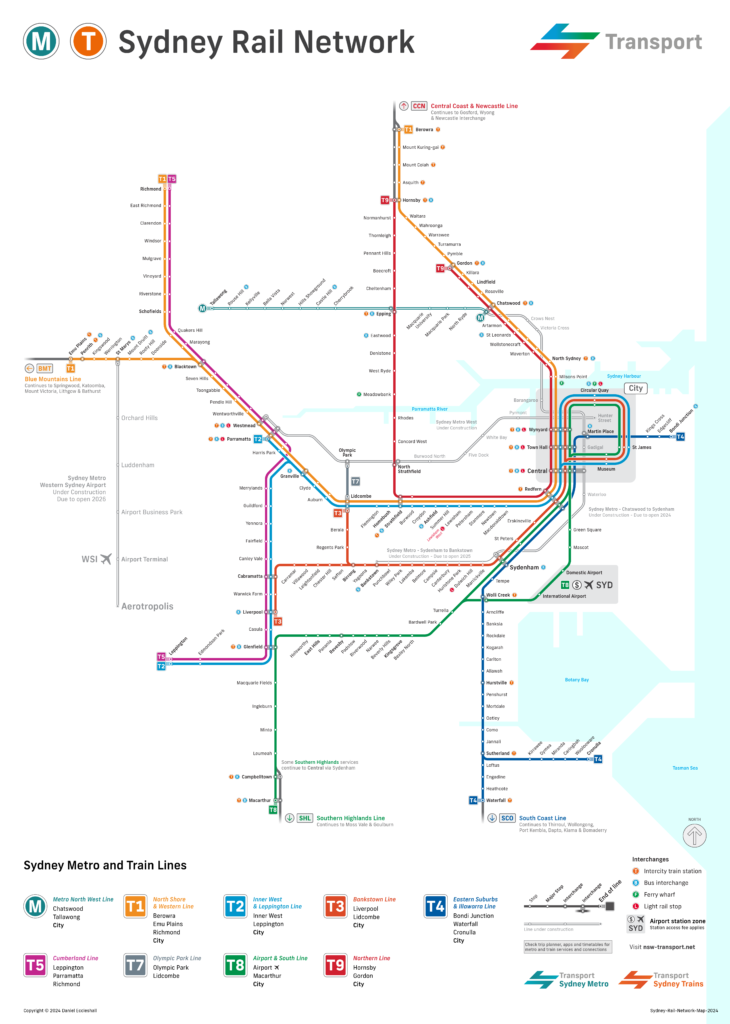
Below we show you the Sydney metro map and some variations. Click on the map to see it larger:


Schedules
- Weekdays and Saturdays: 4:00 AM a 12:00 AM
- Sundays: 5:00 AM a 11:00 PM
Rates
- Precio 1 ticket: 3.73 AUD (about 2.42 USD)
Official Web site
The official website of the metro is this: https://www.transport.nsw.gov.au
History of the subway
The development of the Sydney Metro has been a complex process full of significant stages:
- 1990S-2000S: Several plans were proposed to build a metro system in Sydney, But many were canceled due to funding problems and political changes.
- 2012: The coalition government announced the plan “Sydney’s Rail Future”, which included the construction of “North West Rail Link”, the precursor to today's Sydney Metro.
- 2014: Construction of second crossing under Sydney Harbor approved as part of project “Sydney Rapid Transit”.
- 2015: The system was officially renamed as “Sydney Metro” after the approval of energy privatization laws.
- 2019: Inauguration of the metro line North West, which connects Tallawong with Chatswood, marking the beginning of the country's first automated metro.
- 2020: Completion of the tunnel 15.5 kilometers between Chatswood and Sydenham, part of the City extension & Southwest.
- 2023: Train testing begins under Sydney Harbor, preparing the system for its full opening in 2024.
- 2024: New stations expected to open in central Sydney, significantly improving the city's connectivity.
Sydney Metro Map History
The design of the Sydney Metro map was a collaborative and evolutionary process, involving several design and engineering firms over the years. The goal was to create a map that is not only functional, but also aesthetically pleasing and representative of Sydney's identity.
Designers and companies involved
- DesignInc: This firm has played a crucial role in the design of several elements of the Sydney Metro, including stations and other architectural components. They have worked closely with engineers and contractors to ensure that all structural elements integrate harmoniously.. The design of the railway bridge 135 meters long on the Metro line North West It is one of his most notable projects.
- Alstom: The French company Alstom has designed the trains used in the Sydney metro, adapting its international model “Metropolis” for Sydney's specific needs. These trains are designed to offer level access between the platform and the train, multipurpose areas and advanced real-time information systems.
- Turf Design Studio: They collaborated in creating a coherent visual environment for the Metro North West, working on elements ranging from station platforms to bridges and viaducts. Its focus focused on elegance and integration with the existing and future environment..
Evolution and characteristics of the map
The Sydney Metro map has been designed to be intuitive and easy to use, Inspired by the design principles of iconic tube maps such as the London Underground. Over the years, Updates have been made to reflect new lines and stations, as well as improvements in accessibility and security.
The map is not only used for passenger orientation, but also seeks to convey the visual identity of Sydney, integrating aesthetic elements that reflect the modernity and functionality of the metro system. The use of light colors and clean lines helps passengers navigate the system efficiently.
Additional data
- Technological innovation: The Sydney Metro is the most technologically advanced transport system in Australia, with fully automated trains and fully accessible stations.
- Future projects: Three additional lines are being built: City & Southwest, which will connect Chatswood to Bankstown; Sydney Metro West, that will link Parramatta with Sydney's CBD; y Sydney Metro Western Sydney Airport, that will serve the new International Airport of Western Sydney).
- Cultural and economic impact: The metro improves urban transportation by acting as a catalyst for urban development, improving connections between communities. Besides, provides easy access to important cultural and shopping areas of Sydney, such as Sydney Olympic Park and the financial district.
Important tourist places in Sydney and its subway stations
- Sydney Opera House (Circular Quay, City & Southwest): World icon and UNESCO World Heritage Site, Known for its distinctive sail-shaped architecture. Offers a variety of shows and cultural events.
- Sydney Harbour Bridge (Circular Quay, City & Southwest): A symbol of the city, offers the experience of BridgeClimb for panoramic views and has the Museum Pylon Lookout.
- Darling Harbour (Town Hall, City & Southwest): Area with multiple attractions such as SEA LIFE Sydney Aquarium, WILD LIFE Sydney Zoo and the Australian National Maritime Museum. Ideal for walks, shopping and events.
- The Rocks (Circular Quay, City & Southwest): Sydney's oldest neighborhood, famous for its cobblestone streets, markets, historic galleries and pubs. Offers tours that narrate its rich colonial history.
- Royal Botanic Garden (Martin Place, City & Southwest): Historic gardens with more than 7,500 plant species, Guided tours and spectacular views of Sydney Harbor and Opera House.
- Queen Victoria Building (QVB) (Town Hall, City & Southwest): Historic and elegant building, converted into a shopping center with more than 200 stores. Noted for its Victorian architecture and colorful stained glass windows.
- Sydney Tower Eye (Martin Place, City & Southwest): Sydney's tallest building with an observation deck offering views of 360 degrees of the city and its surroundings. Includes a 4D cinematic experience.
- Taronga Zoo (Milsons Point, City & Southwest, with ferry from Circular Quay): Zoo that houses more than 4,000 animals, including Australian fauna and exotic species. Offers unique experiences such as Roar and Snore.
- Chinatown (Central, City & Southwest): Area full of restaurants, shops and markets offering an immersive experience in Chinese culture. It is known for its nightlife and cultural events.
- Art Gallery of New South Wales (St James, City & Southwest): Gallery housing an extensive collection of Australian art, European and Asian. Offers temporary exhibitions and special events such as “Art After Hours”.
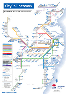
old subway map
In historical mode, We will be posting the old Sydney metro maps in this section. At the moment we have the one of the year 2010:

