Tag Archives: metro

Seoul Subway

The Seoul Subway, locally known as “수도권 전철”, serves the capital of South Korea.

Inaugurated on 15 of August of 1974, This system is one of the largest and most efficient in the world, con 18 lines and 767 stations covering 940 kilometres (584 miles).

Seoul Subway Schedule

The Seoul Metro operates daily from 5:30 a.m. until the 1:00 a.m., facilitating constant movement in the metropolis.

Official websites

Seoul Subway Fares

  • Single ticket price varies from 1250 a 2150 KRW (aproximadamente entre 0,94 USD y 1,62 USD), depending on the distance traveled.
  • Rates for children and young people: There are significant discounts for children and young people, who can register a transportation card and benefit from reduced fares.
  • Early hour discounts: Using a transportation card, passengers traveling before 6:30 a.m. can enjoy a 20% off.

Standard rates

Fares for traveling on the Seoul Metro vary depending on the distance traveled. The base price within the first 10 kilometers is 1,250 KRW. For distances between 10 y 50 kilometres, a supplement is added 100 KRW cada 5 kilometres. Beyond the 50 kilometres, the supplement fits 100 KRW cada 8 kilometres. These rates apply whether you use a transportation card or buy a single ticket.

Discounts for children and youth

There are significant discounts for children and young people, who can benefit from reduced fares when registering a transportation card. These discounts make the system more accessible for families and students, encouraging the use of public transport from an early age.

Descuentos por “Viaje temprano”

The Seoul Subway fare system includes a discount of 20% for passengers traveling before 6:30 a.m. This incentive is designed to encourage riders to travel during off-peak hours., helping to decompress demand during the most congested hours.

Special rates

For passengers who travel frequently, There is a card option with a fixed price of 61,600 KRW that allows up to 44 travel within the Seoul metropolitan area. This option is advantageous for regular travelers, as it offers considerable savings compared to purchasing single tickets for each trip.
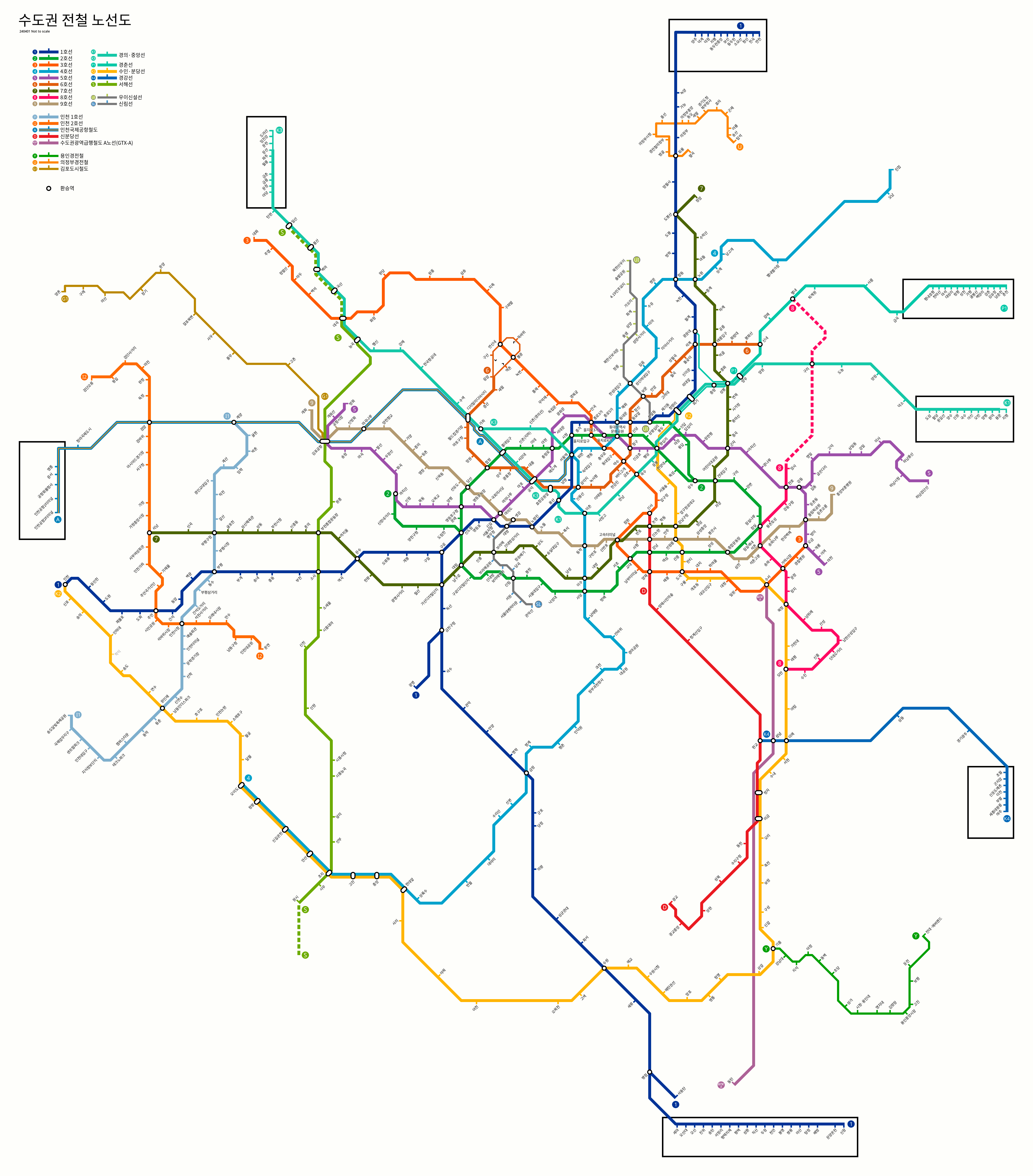
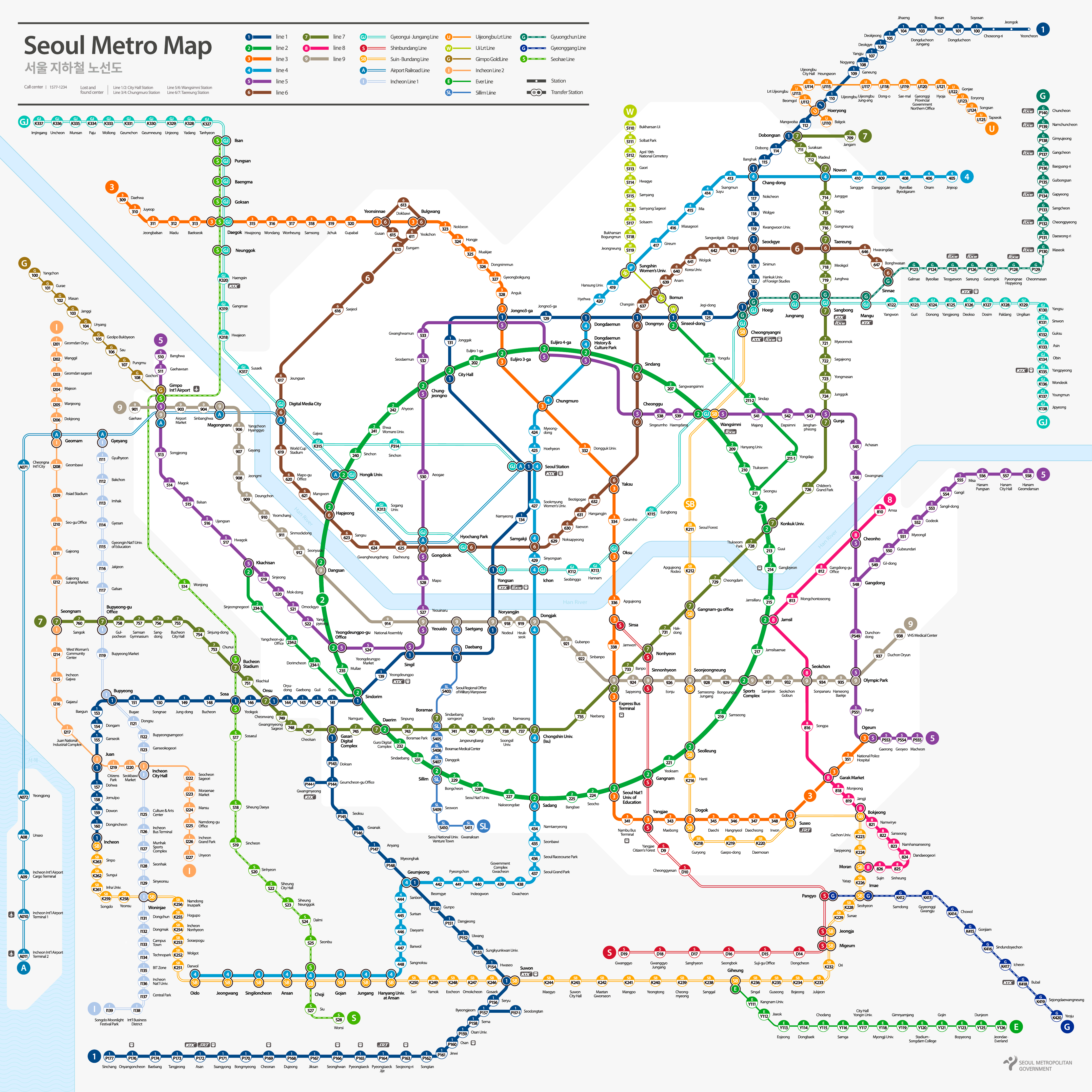
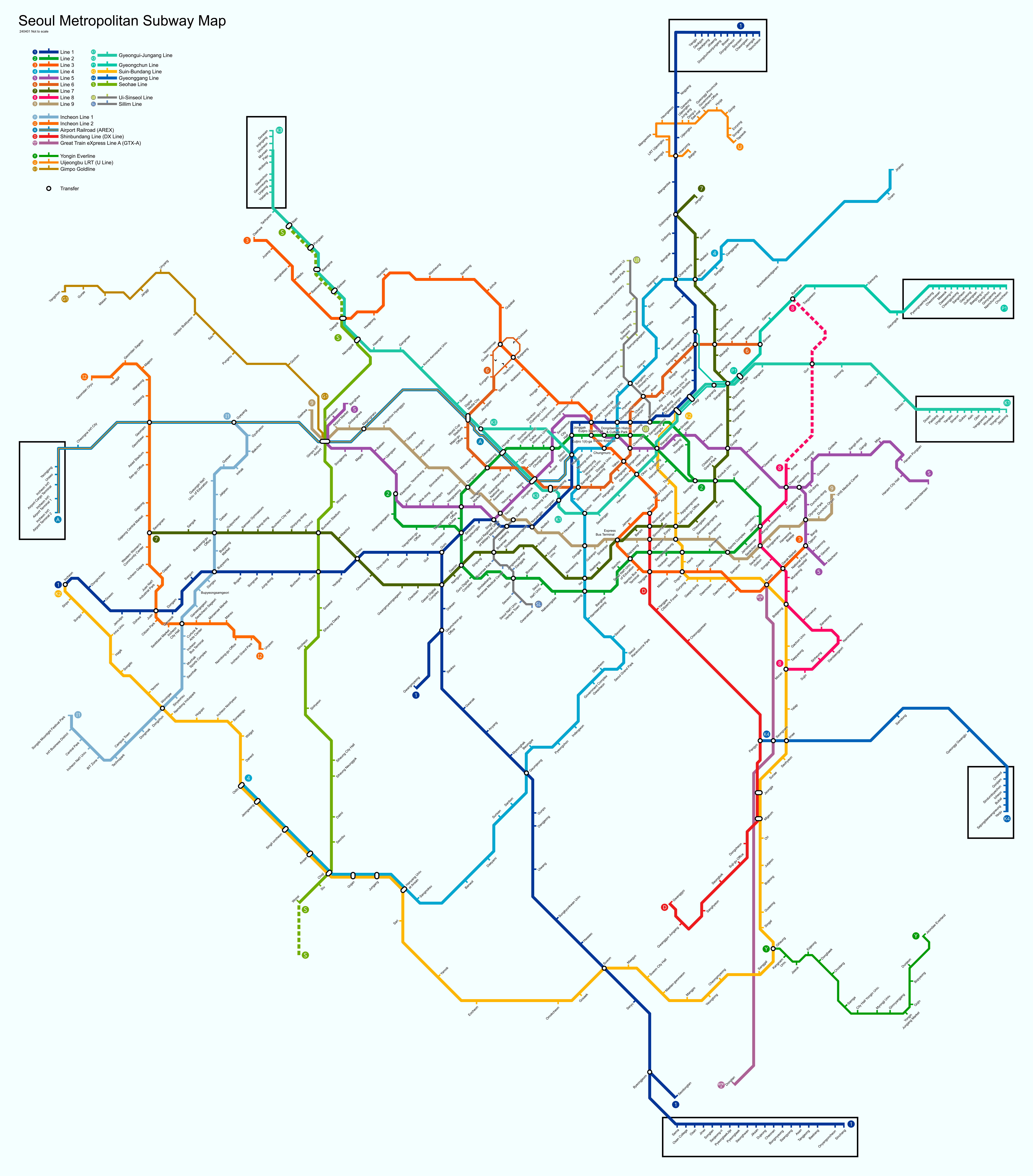
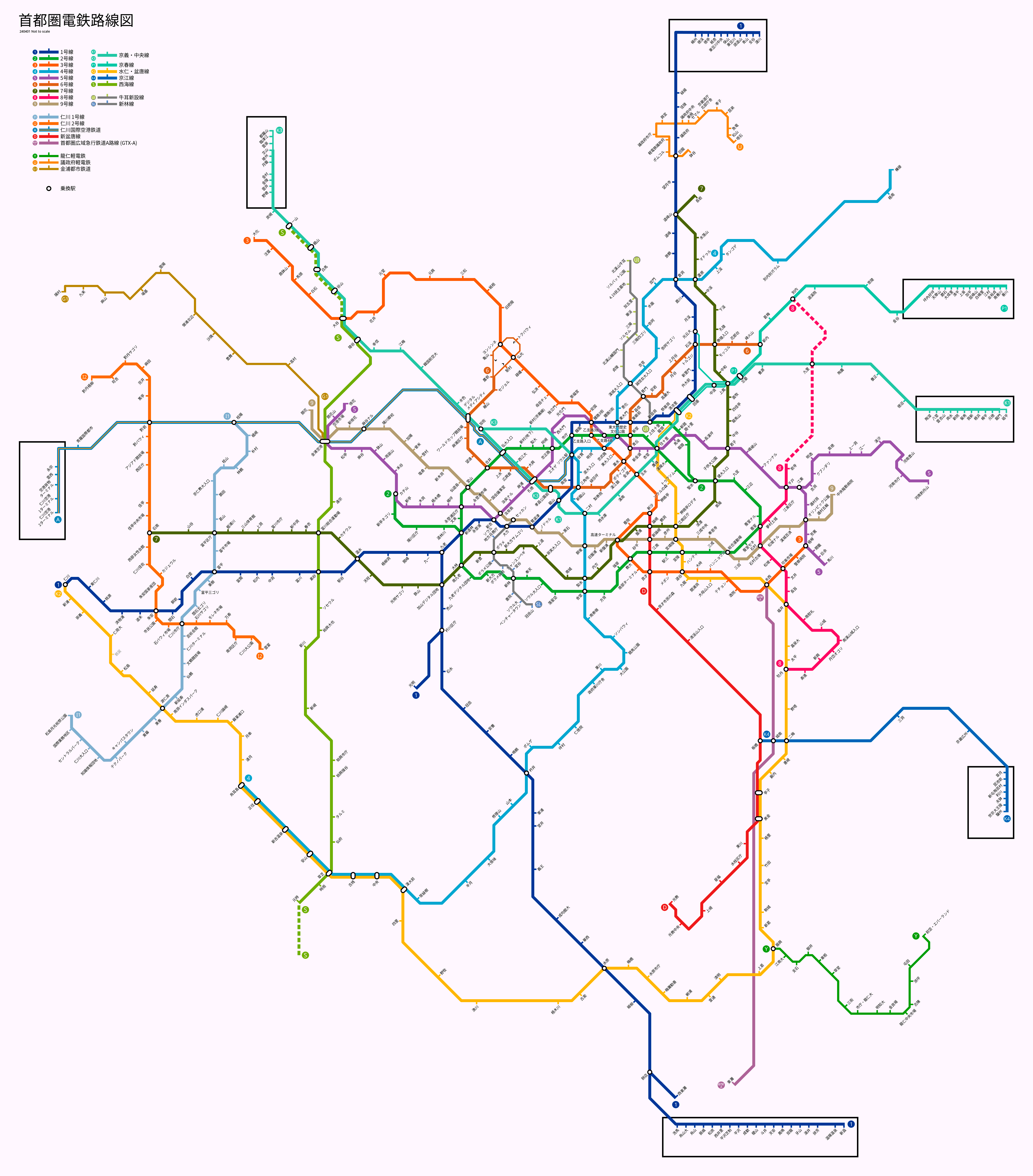
Seoul Subway Map

Below we show you the Seoul Subway map in three different languages..

Maps in Korean language:

Seoul subway map in Korean, year 2024

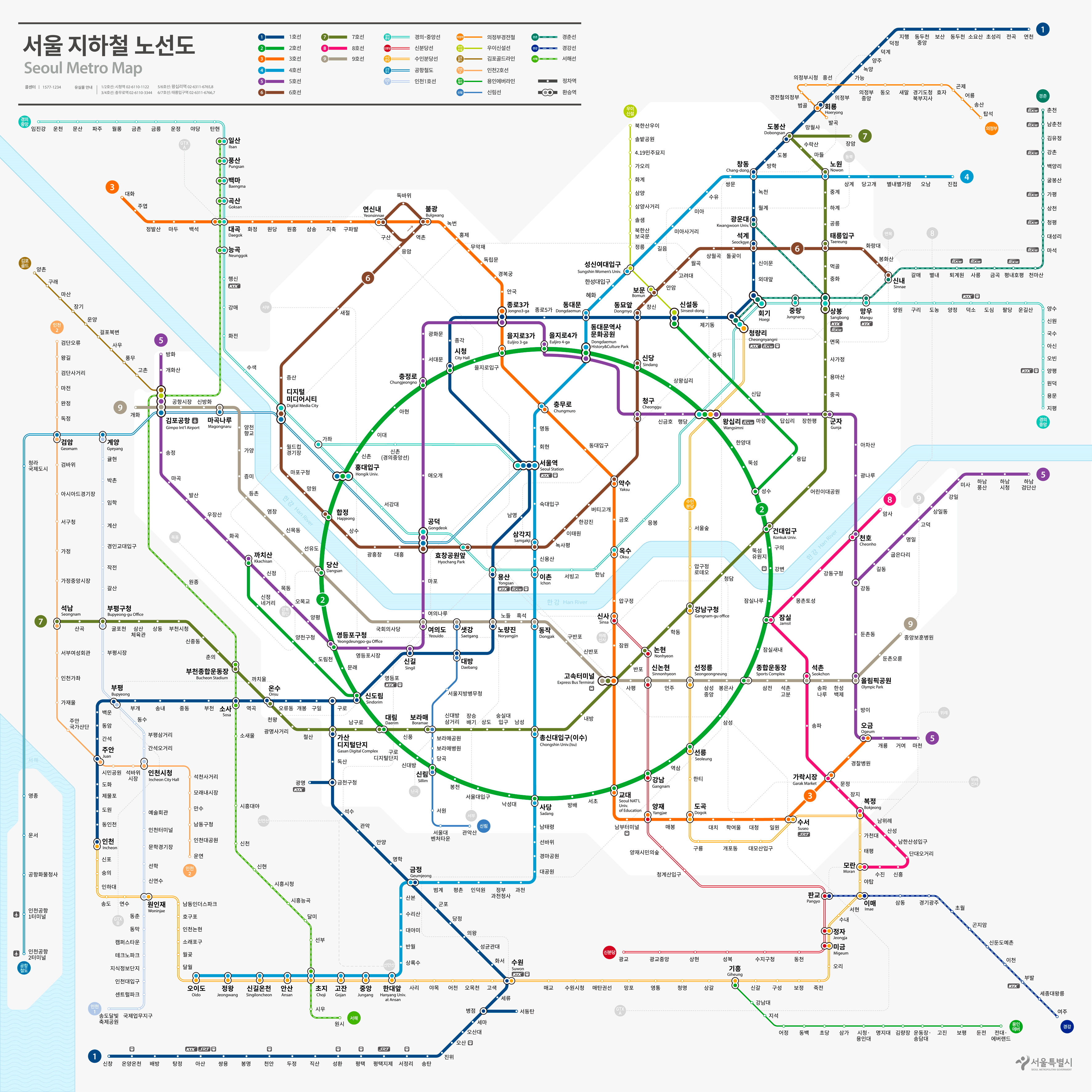
The following is the same map but with the format that existed before the year 2023:

Seoul subway map in Korean, year 2023

Maps in English language:

Seoul metro map in English, year 2024

the same map, but in the old year format 2023.

Seoul metro map in English, year 2023

Map in Japanese language:

Seoul subway map in Japanese

History of the subway

Seoul Subway, inaugurated on 15 of August of 1974, started with the Line 1, an infrastructure that revitalized transportation in the South Korean capital. This system has been developed in response to the growing demand for mobility in one of the most densely populated cities in the world..

Since its conception, The metro has played a crucial role in urban modeling and city planning, influencing the location of new residential and commercial areas.

Seoul subway expansion did not stop with the first lines. In the decade of 1980, lines were added to the metro 2, 3 y 4, while the following decades saw the introduction of lines using advanced technology, such as driverless trains and automatic platform doors to improve passenger safety. The integration of these technological advances has placed the Seoul Metro in a leading position worldwide in terms of efficiency and safety..

The most recent line, the line 9, was inaugurated in 2009 and its last extension was completed in 2021. This line is particularly notable for its express service which significantly reduces travel time between the east and west of the city..

Seoul Subway Map History

The evolution of the Seoul Subway map is a testament to its increasing expansion and complexity. The original design was relatively simple, designed to facilitate understanding of the first four lines. As the system expanded, the map was transformed into a more detailed and aesthetically attractive tool.

One of the significant changes to the map design was the introduction of distinctive colors and iconic symbols for each line in the years 90, making it easier to navigate through the system for locals and tourists alike.

Designers like Kim Hyun-Suk have played a crucial role in modernizing the map, ensuring that as new lines and stations were added, the map remained accessible and easy to use.

The latest map redesign was done to include the Line 9 and its extensions, using a more digital approach that allows integrating real-time updates and facilitating interaction with users through mobile applications and interactive screens at stations.

Additional data

The Seoul Metro is not only crucial for the daily lives of its citizens but also for tourists. Some of the sites accessible via the subway include:

  • Palacio Gyeongbokgung (Gyeongbokgung Station, Line 3): A jewel of Joseon architecture, It is one of the largest and probably the most beautiful palaces in Seoul.
  • Dongdaemun Market (Dongdaemun History Station & Culture Park, Lines 2, 4 y 5): A large shopping complex known for its cutting-edge fashion and local crafts.
  • Torre N Seoul (Myeong-dong Station, Line 4): Offers panoramic views of the city from its location atop Mount Namsan.
  • Insadong neighborhood (Anguk Station, Line 3): Famous for its art shops and traditional cafes, It is an essential place to experience Korean culture.
  • Lotte World Tower (Jamsil Station, Lines 2 y 8): South Korea's tallest skyscraper offers a panoramic view of the city from its observation deck. Its facilities also include a luxurious shopping center and various entertainment attractions..
  • Bukchon Hanok Village (Anguk Station, Line 3): This picturesque neighborhood offers an immersion in Korean tradition and history with its well-preserved Hanok houses. It is ideal for history buffs and those seeking an authentic cultural experience.
  • Hang Park (Yeouinaru Station, Line 5): This sprawling park along the Han River is a popular picnic spot, sports activities and simply to enjoy the tranquility away from the urban hustle and bustle. The park is also famous for its open-air festivals and concerts..
  • Hongdae (Hongik University Street) (Hongik University Station, Line 2): Known for its vibrant artistic and youthful atmosphere, this area offers a wide range of coffees, stores, art galleries and clubs. It is the preferred meeting place for young people and the heart of Seoul's underground entertainment.
  • COEX Mall (Samseong Station, Line 2): One of the largest underground shopping malls in Asia, COEX Mall houses a wide variety of stores, a giant aquarium and the famous K-Pop Hall of Fame, making it a must-see destination for fans of Korean pop culture.
  • War Memorial of Korea (Samgakji Station, Lines 4 y 6): This museum and monument commemorates South Korea's fallen in various conflicts, mainly the Korean War. It is a place of deep historical and educational reflection.
  • Myeongdong Shopping Street (Myeong-dong Station, Line 4): Famous for its fashion stores, cosmetics and its varied gastronomic offer, especially street food, Myeongdong is a paradise for shoppers and those who want to experience modern Korean urban culture.

Each of these sites can be a starting point to explore the city of Seoul, all accessible through its extensive metro network.

Vancouver SkyTrain

Logo Metro Vancouver

The Vancouver SkyTrain is an underground and elevated transportation system that operates in the city of Vancouver, Canada.

Inaugurated on 3 January 1986, has gone through several expansions, with the last one made in 2016. At the moment, It has three lines that add up to a total of 53 seasons and cover 79.6 kilometres (about 49.46 miles).

Although it is sometimes called “Vancouver Metro”, it's a automated light rail system. It gets its name because most of its infrastructure is elevated, allowing for panoramic views as you travel above the city streets and avenues. Being on elevated roads, looks “float” in the sky. Besides, some sections are also underground, allowing uninterrupted circulation.

This system is essential for the daily mobility of residents and tourists, providing access to different areas of Vancouver and the metropolitan region.

Metro Map

Below we show you the map of the Vancouver SkyTrain:

Map of Metro Vancouver

Schedules

The Vancouver SkyTrain operates with the following schedules:

  • Work days: of 5:00h a 1:00h.
  • Saturdays: of 5:00h a 1:00h of the next day.
  • Sundays and holidays: of 6:00h a 0:00h.

Rates

The system offers several options for passengers:

  • One-way ticket: 2.95 CAD (~2.17 USD) for a single trip.
  • DayPass: 11 CAD (~8.09 USD) for unlimited rides for one day.

Official Web site

For more information, visit the Vancouver SkyTrain Official Site.

Website with the complete list of tourist attractions in Vancouver in the popular ticket sales website. In addition to discovering new options, you can buy tickets in advance, avoiding long lines, bad weather and, sometimes, get a discount 20%.

History of the Vancouver SkyTrain

Vancouver's SkyTrain is a notable milestone in Canadian public transportation, initially inaugurated as part of Expo '86. The Expo Line, the first to work, revolutionized urban mobility in Vancouver, connecting its inhabitants to the city center and establishing a solid foundation for future expansion. Since then, The evolution of the system has been marked by meticulous planning and a constant commitment to innovation. With the addition of the Millennium Line in 2002, the SkyTrain expanded into the eastern suburbs, increasing its network to serve a growing population in Burnaby, New Westminster y Coquitlam. The Canada Line, inaugurated in 2009, spread the network further, linking Vancouver with Vancouver International Airport and the city of Richmond.

The SkyTrain has been a pioneer in the implementation of advanced technology in driverless trains, standing out for its automated operation that allows a fast and efficient service frequency. In addition to its main lines, The system has continued to expand to serve new urban areas and meet the demands of a growing city, demonstrating a commitment to sustainability and continuous improvement.

History of the SkyTrain map

The SkyTrain map has evolved over time to reflect the transformation and growth of the transportation system.

In the first days, the map was simple, focused solely on the Expo Line, with limited but effective connections to the heart of Vancouver. As the Millennium Line and Canada Line were added, The map was adapted to illustrate the growing complexity of the network and its connection with other modes of transport..

One of the most important names in this evolution is Ken Sutherland, a graphic designer who worked extensively on modernizing SkyTrain maps. His approach was based on visual clarity and simplicity, ensuring that passengers could easily understand routes and connections.

The map's clarity and distinctive style have become a symbol of the system's accessibility, allowing both residents and tourists to navigate the city with ease. More recent editions have incorporated interactive digital elements and real-time updates.

Additional data

Vancouver's SkyTrain is not only an efficient transportation system, but also a gateway to some of the city's most impressive attractions:

  • Stanley Park (Burrard Station): This station connects visitors to the iconic park that features scenic trails and a unique mix of nature and cultural activities..
  • Granville Island (Yaletown-Roundhouse Station): A short distance from this station is the bustling market and arts center, offering a unique culinary and cultural experience.
  • Anthropology Museum (UBC Loop Station, bus access): Although it is not directly connected to the SkyTrain, The museum can be accessed via buses from the nearest station, highlighting the rich cultural heritage of the indigenous peoples of the region.
  • Gastown (Waterfront Station): The station serves as a portal to one of Vancouver's oldest historic neighborhoods, famous for its steam clock and modern boutiques.

Antwerp Premetro

Logo meter Antwerp (Antwerp)

The Antwerp Premetro, officially known as “Antwerpse premetro”, is the underground transportation system in the city of Antwerp, Belgium.

Inaugurated on 25 March 1975, It has a line that operates along 11 stations, covering 7.6 kilometres (about 4.72 miles).

Although sometimes they call him “Antwerp metro”, It is technically a premeter due to its relatively small size.

Schedules

The Antwerp Premetro operates with the following schedules:

  • Work days: of 5:00h a 0:00h.
  • Saturdays: of 5:30h a 0:00h.
  • Sundays and holidays: of 6:00h a 0:00h.

Rates

The system offers the following rate options (year 2024):

  • One-way ticket: 3 EUR (~3.29 USD) for a single trip.
  • Day Ticket: 7.50 EUR (~8.24 USD) for unlimited rides for one day.

Official Web site

For more information, visit the official site of the Antwerp Premetro.

Complete list of tourist attractions in Antwerp in the popular Ticket sales website. In addition to discovering new options, you can buy tickets in advance, avoiding long lines, bad weather and, sometimes, get a discount 20%.

Metro Map

Below we show you the map of the Antwerp Premetro:

Subway Map Antwerp (Antwerp)

PDF version of the map: Underground Map Antwerp (Antwerp).pdf

History of the premeter

The history of the Antwerp Premetro is marked by a series of important milestones in the evolution of the city's underground transport.. Its construction was originally conceived as a large-scale metro system covering two main axes.: one east-west and one north-south, connecting strategic points such as the Central Station and the Sportpaleis.

The first underground segment, which included the Groenplaats stations, Meir and Opera, was inaugurated in 1975, initially attending the lines 2 y 15.

For 1980, the system had expanded with the opening of the Diamant and Plantin station. During the decade of 1980, tunnel construction continued, with a focus on the north-south axis and the creation of the Brabo tunnel under the River Scheldt, Completed in 1990. The development of underground sections and new stations was temporarily stopped at the end of the 1990s. 1980 due to lack of funds.

In the following decades, new lines were added, as the 5 in 2006 and the 6 in 2007, that took advantage of previously unused tunnels.

From 2015, Partially closed stations such as Astrid and Opera were reactivated, Meanwhile he “Pegasus Plan” was approved to connect eastern areas and open new routes in the city such as the incorporation of the new Zegel station in 2015.

Stations such as Drink and Morckhoven are being developed under the leadership of a multidisciplinary team made up of GROUP A, Archipelago y Tractebel. This team has focused on maintaining the historical integrity of the design, while adapting it to the modern urban context, emphasizing the integration with the urban landscape and the use of contemporary materials

History of the Antwerp premetro map

The creation and evolution of the map of the “metro” from Antwerp, known locally as the Premetro, has followed a process of continuous refinement to accurately reflect network connections and expansions. Initially, the plan provided for a metro system, but a premetro was chosen to integrate it with the existing tram network.

The first sketches were made by local engineers and technicians during the construction of the first line, with a rudimentary approach that showed only existing routes.

As the network expanded, the map became more complex, evolving under the supervision of cartographers such as Paul Van Steenkiste, who had a notable influence on its refinement. Van Steenkiste and other designers were inspired by transportation maps of other major cities., especially in the “diagram style” of the London subway.

Their efforts resulted in a more stylish and efficient design., which allows travelers to easily identify the routes and stations of the system.

The modern map reflects a design that encompasses 11 commercial stations and multiple connections. The expansions of the Premetro in the decades of the 80 y 90, with the addition of tunnels such as the Brabotunnel and the Reuzenpijp, enriched the design, capturing critical routes like the Line 15 que connect Boechout with Linkeroever.

Additional data

The Antwerp Premetro is a gateway to the most emblematic places of the city. Some stations of interest include:

  • Meir: Close to the most popular shopping street in Antwerp, Meir, with shops, restaurants, and the impressive Cathedral of Our Lady, a Gothic monument that houses works by Rubens.
  • Antwerp Central Station: Antwerp central station, known as the “Railway Cathedral”, It is a place of interest in itself. From here, easy to get to Antwerp Zoo and Diamantkwartier, the diamond district.
  • Museum aan de Stroom (BUT): Accessible from Van Eeden station, The MAS is a museum that tells the port history of Antwerp with an impressive collection of art and historical objects.
  • Plantin-Moretus: From Groenplaats station, you can visit the Plantin-Moretus Museum, a gem declared a World Heritage Site by UNESCO, which houses one of the oldest printing presses in the world.
  • Left Bank: This station provides access to the Sint-Annastrand park on the left bank of the Scheldt River, a perfect place to relax by the water with a panoramic view of the city.

Vienna Metro

The Vienna Metro, officially known as “U-Bahn Wien”, is the underground transportation system in the capital of Austria.

Inaugurated on 25 February 1978, has grown over time, with its latest expansion in 2010.

Currently it has 5 lines, 101 stations, and covers 75 kilometres (about 46.60 miles). It is essential for the daily transportation of millions of residents and tourists visiting Vienna..

Schedules

The Vienna Metro operates with the following schedules:

  • Every day: of 5:00h a 00:30h.
  • Friday, Saturdays and the eve of holidays: continuous service throughout the night.

Rates

The system offers the following options for passengers:

Type of ticketPrice in EUR (USD)Details
One-way ticket2.40 EUR (~2.63 USD)a single trip.
24h ticket8 EUR (~8.77 USD)Unlimited trips for one day.
48h ticket14.10 EUR (~15.45 USD)Unlimited trips for two days.
72h ticket17.10 EUR (~18.74 USD)Unlimited trips for three days.
Vienna metro prices.

Official Web site

For more information, visit the official site of the Vienna Metro.

To see a list of all tourist attractions what's in vienna, we recommend using the famous ticket website. In addition to seeing options that I didn't know about, you can buy tickets in advance, avoid queues, bad weather and sometimes with 20% off.

Metro Map

Below we show you the Vienna Metro map:

Mapa metro Vienna (Vienna U-Bahn)

Here is the same map in PDF format: Metro Map Viena.pdf

History of the Metro

The Vienna Metro, known as U-Bahn, has had a fascinating evolution that has left an indelible mark on the history of European urban transport. Although the modern system was inaugurated in 1978, Its true origin dates back to the beginning of the 20th century.

During the era of the Austro-Hungarian Empire, Vienna already had a light rail network that, largely, laid the foundations for the design and planning of the current underground infrastructure.

World War II stopped their progress, and efforts to revitalize urban transportation did not resume until after the conflict.

The U-Bahn current has grown from three lines in its first years to a network of five routes that cover more than 80 kilometres.

The implementation of cutting-edge technologies has allowed the operation of trains efficiently, with a robust security system that makes it an example in Europe.

Vienna Subway Map History

The design of Vienna's subway maps also has a significant history.

Initial planning involved a team of engineers and designers under the direction of Otto Wagner, a famous Austrian architect and urban planner who influenced public transport planning in Vienna.

On the first years, The maps were quite rudimentary., but with the expansion of the system in subsequent decades, a more sophisticated approach was required.

The current design is the work of a team led by transportation systems designer Kurt Kolb, who since the years 70 managed to maintain a coherent vision of the route scheme, making the map visually clear and easy to interpret for millions of commuters.

Additional data

The Vienna Metro in addition to connecting local inhabitants and tourists with their destinations efficiently, It also offers access to some of the most emblematic points of the city:

  • Schönbrunn Palace: Accessible from the metro station Schönbrunn on line U4, this palace, declared World Heritage, It is an architectural gem that offers a glimpse into Austrian imperial history.
  • St. Stephen's Cathedral: The subway station Stephansplatz on line U1 leaves you in the heart of Vienna, right next to this imposing gothic cathedral.
  • Vienna State Opera: Just a few steps from the subway station Karlsplatz (U1 lines, U2, U4), the famous opera house is an essential cultural landmark.
  • Museum of Natural History: Located near the metro station Folk Theater (lines U2 and U3), This museum houses one of the largest natural history collections in Europe.
  • Vienna City Hall: From the subway station City hall on line U2, you can reach the majestic neo-Gothic building that houses the city's municipal offices.

Prague Metro

Logo Metro Prague

The Prague Metro, officially known as “Pražské metro”, It is the underground transportation system that connects the capital of the Czech Republic.

Inaugurated on 9 May 1974, This system has experienced constant expansion, with the last extension carried out in 2023.

At the moment, has 3 lines that cover 61 stations along 65.2 kilometres (about 40.51 miles). It is essential for the daily mobility of residents and tourists exploring Prague.

Prague metro timetable

The Prague Metro operates with the following schedules:

  • Every day: of 5:00h a 0:00h.

Rates

Prague Metro offers several options for passengers:

TypePrecioDetails
One-way ticket30 CZK (~1.30 USD)a single trip.
Bill of 90 min40 CZK (~1.73 USD)trips during 90 minutes in any medium.
Bill of 24 h120 CZK (~5.19 USD)Unlimited trips for one day.
Monthly payment550 CZK (~23.79 USD)Unlimited trips for one month.
Prague Metro Price Table

Official Web site

For more information, visit the Prague Metro official site.

To see a list of all tourist attractions what's in Prague, and be able to buy tickets in advance, save queues, bad weather and sometimes even 20% off, we recommend using the ticket website.

Prague metro map

Below we show you the Prague Metro map:

Map of Prague metro

History of the subway

The Prague Metro, inaugurated on 9 May 1974, started with Line C, marking the birth of a crucial transportation system for the city. The first section connected the stations from Kačerov to Florenc. This event marked a milestone in the urban development of Prague, introducing a modern solution for the mobility needs of its growing population.

Expansion and Development

The Prague Metro, inaugurated on 9 May 1974 with Line C, has been an essential component of transportation infrastructure.

Unlike Vienna's metro system, which evolved from a network initially operated by steam locomotives from the late 19th century, The Prague metro was a later development, planned and built to meet modern demands for efficient urban transportation.

Beginnings and Initial Expansion

The system began with Line C, que conectaba Kačerov con Florenc. This line was designed to facilitate quick access through key areas of the city, significantly improving connectivity. Posteriorly, Lines A and B were developed in response to the growing need for a broader network:

  • Line A: Inaugurated in 1978, conectó Dejvická con Náměstí Miru, gradually expanding in subsequent years.
  • Line B: It started operating in 1985, linking Florenc with Smíchovské nádraží and later spreading to other areas.

Political Changes and Modernization

During the socialist era, The subway's design and expansion were closely aligned with industrial and central planning needs. However, the Velvet Revolution 1989 marked a turning point, triggering a series of modernizations in metro infrastructure and services. This included the renovation of stations, improving operational security and introducing modern ticketing and access control technologies.

Continuous Modernization

Throughout the decades of 1990 y 2000, Prague Metro continued to evolve to improve efficiency and user comfort. Automated systems and more modern rolling stock were incorporated, which increased the frequency and capacity of the lines, thereby improving the overall user experience.

Future Planning and Expansion

The system has not stagnated; Planning for the future Line D suggests continued expansion to better connect the center with the southern suburbs. This project is designed to relieve congestion on existing lines and offer more direct service to currently underserved areas..

This focus on continuous improvement and planned expansion reflects a commitment to adapting to the changing needs of the city and its inhabitants., ensuring that the Prague Metro remains a vital and efficient public transport system for the Czech capital.

History of the Prague metro map

The initial design of the Prague Metro map, obra de František Kolář and Jiří Lampa, focused exclusively on Line C, reflecting his journey from Kačerov to Florenc. This map served as a basic visual guide for early subway users in 1974.

Map Evolution and Adaptation

With the expansion of the system and the inauguration of Line A in 1978 and Line B in 1985, the map evolved to integrate these new routes. A color-coded system was adopted to facilitate distinction between lines: green for Line A, yellow for Line B, and red for Line C. This color system not only improved the functionality of the map, but also made it visually more accessible for passengers.

The map layout received significant updates in 1985 with the addition of Line B, where graphical elements were refined to provide a clearer and more detailed representation of the expanding network. These modifications allowed users to better understand the interconnections and plan their routes more effectively..

Modernization and Visual Clarity

As Prague continued to expand its metro network, The map design was also adapted to incorporate new stations and lines, including planning for the future Line D.

The modern map design stands out for its clarity, using icons and signage that provide an accurate overview of important connections and correspondences between lines.

This consistency in signage helps with orientation within the system and improves the navigation experience for daily users and tourists..

.

Additional data

The Prague Metro effectively connects the city's main points of interest:

Places on line A

  • Bridge of Carlos: It can be accessed from Malostranská station on Line A.
  • Astronomical clock: Located in the Old Town Square, the clock is conveniently located a short distance from the Staroměstská station (Line A).
  • Prague Castle: This famous complex is located near the Hradčanská station, on the same Line A.

Line B

  • Jewish Quarter: Accessible from Staroměstská station, on Line A, about Republic Square, on Line B.
  • Dancing House (The Dancing House): For lovers of modern architecture, The Dancing House is accessible from the Karlovo Náměstí station on Line B​.
  • Old Town Square: Near Staroměstská stations (Line A) y Republic Square (Line B).
  • O2 Arena: Located near the Českomoravská metro station on Line B, The O2 Arena is an important event and concert center.
  • Center Černý Most: Large shopping center located near the Černý Most metro station (Line B), offering a variety of shopping and entertainment.

Line C

  • National Museum (National Museum): It's right next to the Muzeum station. (lines A and C), there they have collections of cultural and historical artifacts.
  • Vysehrad Castle: For a dose of history, you can visit Vyšehrad castle, close to Vyšehrad station on Line C. Besides the castle, The area offers beautiful views of the Vltava River and the city.
  • PVA Expo Prague en Letňany: It is a place for fairs and exhibitions, accessible from Letňany station on Line C.
  • National Technical Museum: For those interested in technology and engineering, this museum offers exhibitions and is close to Vltavská station (Line C​).

Metro Hamburg

Logo Metro Vienna (Vienna U-Bahn)

The Metro Hamburg, officially known as “Hamburger U-Bahn”, is the underground transportation system that serves the city of Hamburg, Germany.

Inaugurated on 1 March 1912, has grown to include 4 lines that connect 93 stations. The network covers a length of 106.4 kilometres (about 66.11 miles) and is essential for the daily transportation of residents and tourists.

Schedules

The Hamburg Metro operates with the following schedules:

  • Every day: continuous service 24 hours with different frequencies.

Rates

The system offers several options for passengers:

TypePrecioInformation
One-way ticket3.30 EUR (~3.62 USD)For a single trip
Bill of 9:00h6.90 EUR (~7.57 USD)Valid all day from 9:00h
Party ticket13.10 EUR (~14.38 USD)For a group of up to 5 people for a day
Hamburg metro ticket prices.

Official Web site

For more information, visit the official site of the Hamburg Metro.

To see a list of all tourist attractions what's in Hamburg, and be able to buy tickets in advance, save queues, bad weather and sometimes even 20% off, we recommend using the ticket website.

Metro Map

Below we show you the map of the Hamburg Metro:

Hamburg subway map
mapa Hamburg Metro map 2

History of the Metro

The Metro Hamburg (U-Bahn) was inaugurated in 1912 to improve mobility in a city that was already a bustling port and commercial center. Your first line, that connected Rathaus (City Hall) with Barmbek, represented a major advance in transportation infrastructure.

During the First World War and the intervening periods, metro development slowed down, but the expansion continued in the following decades, particularly during the postwar years.

The network survived World War II with relatively minor damage and underwent major reconstruction and expansion in the 1990s. 1950, with the implementation of modern signaling and control technologies to guarantee safety and efficiency.

In the decades that followed, the network was extended to include underground lines, elevated and surface, connecting diverse districts and adapting to the growing demands of an expanding population.

Nowadays, the system continues to evolve to offer convenient services, efficient and environmentally friendly.

History of the Hamburg subway map

Among its first designers stands out Emil Schumann, a pioneer in transportation mapping who worked to simplify the presentation of original routes. During the 20th century, The map was updated periodically with the expansion of new lines and stations.

In the decade of 1960, after the introduction of Line U2, The map design was standardized with a “diagram style” which made it easier to read.

Other designers and cartographers have contributed to the refinement of its modern style., like Hans Joachim Helm, who in the years 80 Improved visual clarity by reducing graphical clutter.

Additional data

The Hamburg Metro connects passengers to some of the city's most iconic places:

  • Port of Hamburg: Can be accessed from the station Jetties, Located in the heart of port activity and an excellent starting point for exploring the seafront.
  • miniature wonderland: The nearest station is Baumwall, facilitating access to this world famous attraction.
  • City of Altona: Altona It is a station that connects with this vibrant district, home of markets, cafes and rich history.
  • Planten un Blomen Park: Station Stephansplatz provides direct access to this green oasis, ideal for a relaxing walk.
  • Elbphilharmonie: Station Baumwall offers a quick connection to this architectural gem, famous for its design and acoustics.

Metro Nuremberg (U-Bahn)

General description

Nuremberg Metro, officially known as “Nürnberger U-Bahn”, is the underground transportation system that connects the city of Nuremberg, Germany. It was inaugurated on 1 March 1972 and has continued to expand until its last extension in 2021.

The system has 3 lines, 49 stations, and covers 38.2 kilometres (about 23.74 miles). It is essential for the mobility of residents and tourists exploring Nuremberg.

Schedules

The Nuremberg Metro operates with the following schedules:

  • Weekdays and Saturdays: of 5:00h a 0:00h.
  • Sundays and holidays: of 7:00h a 0:00h.

Rates

The system offers the following rates (year 2024):

Type of ticketPrice in EUR (USD)Details
One-way ticket3.10 EUR (~3.40 USD)a single trip.
Day Ticket8.20 EUR (~8.99 USD)Unlimited trips for one day.
Party ticket12.30 EUR (~13.48 USD)Until 6 people for a day.
Nuremberg subway prices.

Official Web site

For more information, visit the official site of the Nuremberg Metro.

Metro Map

Below we show you the map of the Nuremberg Metro:

Nuremberg metro map 10
Nuremberg metro map 9
Nuremberg metro map 1
Nuremberg metro map 2
Nuremberg metro map 3
Nuremberg metro map 4
Nuremberg metro map 6
Nuremberg metro map 7
Nuremberg metro map 8

History of the Metro

Nuremberg Metro, who began his service in 1972, marked a milestone in public transport in the city and state of Bavaria. Its creation was the result of strategic planning aimed at addressing population growth and increased demand for efficient transportation..

Over the decades, has expanded significantly, going from a single line to an extensive system of three main lines.

The adoption of driverless automatic trains, an advance that was introduced in 2008, positioned the Nuremberg Metro as Germany's first fully automated underground train system.

This advance not only allowed for safer and more efficient operation, but also reflected the city's commitment to innovation and the use of cutting-edge technologies in public transportation.

History of the Nuremberg subway map

The Nuremberg Metro map has evolved over the years, reflecting the expansion and modernization of the system.

Designers and planners like Ernst Henneberg, who was responsible for the first plans and layouts, They played a fundamental role in the creation of the first maps that guided passengers.

As more stations were added and lines extended, The map design was refined to include clearer and more legible outlines.. The inclusion of differentiated color systems for each line facilitated quick identification of routes.

More recently, The upgrade work has been supervised by the Nuremberg Transport Association (VGN), that continues to adapt design to the needs of modern travelers, integrating digital technology for real-time localization and offering digital versions online.

Additional data

The Nuremberg Metro is not only an efficient means of getting around, but also connects directly with some of the most prominent tourist sites in the city.

For example, station Lorenzkirche brings visitors to the Gothic St. Lawrence Church and the Königstraße pedestrian zone. from the station Rathenauplatz, you can reach the Railway Museum, where Germany's rich railway history comes to life. To visit Nuremberg Zoo, travelers can get off at the station Zoo.

The Documentation Center, Located on the former Nazi Party congress grounds, It is easily accessible from the station Documentation Center. In addition to these points, The metro has been fundamental in promoting urban sustainability, since its use significantly reduces private vehicle traffic, thus contributing to a cleaner and more environmentally friendly city.

Santiago Metro

Logo metro Santiago

The Metro de Santiago, officially known as “Santiago Metro”, It is the underground transportation system in the capital of Chile. Inaugurated on 15 September 1975, has gone through a series of expansions, with the most recent in 2023. The system currently has 7 lines, 136 stations, and covers 103 kilometres (about 64.00 miles). It is one of the fundamental pillars for the daily transportation of millions of passengers who move through the city., connecting important areas such as the center of Santiago with peripheral neighborhoods.

Schedules

The Santiago Metro operates with the following schedules:

DayTime
Work days6:00 am – 11:00 pm
Saturdays6:30 am – 11:00 pm
Sundays and holidays8:00 am – 11:00 pm
Santiago de Chile metro schedules.

Rates

The system offers different rates depending on the time of day, The schedules of the different tariff periods are as follows:

  • 06:30 – 07:00: Valley Schedule (tomorrow)
  • 07:00 – 09:00: Peak Hours (tomorrow)
  • 09:00 – 18:00: Valley Schedule (average)
  • 18:00 – 20:00: Peak Hours (afternoon)
  • 20:00 – 21:00: Valley Schedule (evening)
  • 21:00 – 23:00: Low Hours (evening)

(How not to end up crazy with so many schedules…)

And these are the prices according to the time of day:

Schedule TypeRate (CLP)Rate (USD aprox.)
Valley Schedule800 CLP~0.96 USD
Peak Hours830 CLP~1.00 USD
Low Hours710 CLP~0.85 USD
Santiago metro ticket price table

There are special passes and rates for seniors and students..

Official Web site

For more information, you can visit the official website of the Santiago Metro.

Metro Map

Below we show you the map of the Santiago Metro:

Map Santiago Metro
Map Santiago Metro

History of the Metro

The Santiago Metro was inaugurated in 1975 with the line 1, which initially connected San Pablo and La Moneda. This was an important step forward in the modernization of Chilean public transportation..

During the decade of 1980, the line was opened 2 and line extensions 1 to extend the reach of the system to the north and east of the city. In the following decade, The lines were built 4 y 5 to connect more communities and diversify the available routes.

The network expanded further with the inauguration of the Line 6 in 2017, offering automated stations and driverless trains, while the Line 3, open in 2019, facilitated the connection between the north and the center.

History of the Santiago metro map

The close-ups, designed in collaboration with local professionals and international experts, presented the initial single line network.

Over time, the map grew to represent the five-line network currently in operation, reflecting every extension, like the line 1 which extends eastward to Los Dominicos, or the Line 6 that connects Cerrillos with Los Leones.

A name that stands out in the history of metro maps is that of Santiago Arias, the Chilean designer who was instrumental in the creation of the first versions and who established a visual standard still respected.

Additional data

The Santiago Metro is a crucial tool for tourists looking to move efficiently around the city and discover its main attractions.. Some key stations connect to places of great interest, as:

  • La Moneda Station (Line 1): Close to the La Moneda Palace, the presidential headquarters.
  • Plaza de Armas Station (Line 5): Direct access to the iconic plaza and the Metropolitan Cathedral.
  • Fine Arts Station (Line 5): Entrance to the Lastarria neighborhood and the National Museum of Fine Arts.
  • Baquedano Station (Line 1 y 5): Gateway to the popular Bellavista neighborhood and close to the Forest Park.
  • Patronato Station (Line 2): Next to Central Market, ideal to enjoy local cuisine.

Rome Metro

The Rome Metro, officially known as “Metropolitana di Roma”, is the underground transportation system in the capital of Italy. Inaugurated on 10 February 1955, has grown over the years, with the latest extension in 2022.

Rome metro logo

The system consists of 3 lines that cover 73 stations along 60 kilometres (about 37.28 miles). It is essential for the daily mobility of residents and tourists visiting Rome..

Schedules

The Rome Metro operates with the following schedules:

DayTime
Work daysOf 5:30 h a 23:30 h
Fridays and SaturdaysOf 5:30 h a 1:30 h of the next day
Sundays and holidaysOf 5:30 h a 23:30 h
Rome metro timetables

Important: Of the 8 from April to 5 December 2024, Line A closes at 21:00 Sunday to Thursday, due to works. Fridays and Saturdays, They have their normal hours until 1:30 of the night.

Rates

The price of the tickets (year 2024) most used are the following:

Type of ticketPrice in EURPrecio USD (approx.)Description
One-way ticket1.50 EUR~1.64 USDa single trip
Roma 24H7 EUR~7.68 USDUnlimited trips during 24 hours
Roma 48H12.50 EUR~13.71 USDUnlimited trips during 48 hours
Rome 72H18 EUR~19.73 USDUnlimited trips during 72 hours
Rome metro fares

Official Web site

For more information, you can visit these websites:

Rome metro map

Below we show you the map of the Rome Metro, that we have taken from mappametroroma.it, They already update the map frequently:

Rome metro map

History of the Metro

The Rome Metro was inaugurated on 9 February 1955, marking a milestone in urban mobility in the Italian capital. The first line, Line B, It connected the Termini station with the EUR neighborhood, Designed for the Universal Exhibition in Rome 1942, which was not held due to World War II.

In 1980, The inauguration of Line A established a more robust system, providing an essential connection from the suburbs to the historic center.

Over time, the network has adopted cutting-edge technology, as modern signaling systems, to improve efficiency and safety. At the moment, The Rome metro is an integral part of public transport, helping to alleviate the city's traffic congestion.

History of the Rome metro map

The subway map has evolved along with the transportation system. Initially, The route was simple due to the few existing stations, but as the lines grew, map design adapted to reflect increasing complexity. Italian designers and cartographers, as Roberto Di Laurentiis, participated in creating a clear visual representation for residents and tourists.

The current layout is easily understandable and follows the standards of modern transportation maps, using colors to differentiate lines A, B y C, with prominent markers for connection and transfer points.

Additional data

Rome's metro connects passengers to some of the city's most important tourist sites:

  • Coliseum: Station “Colosseum” on Line B provides direct access to the famous Roman amphitheater.
  • Vatican: Station “Octavian” on Line A is the entrance to St. Peter's Basilica and the Vatican Museums.
  • The Trevi Fountain: Station “Barberini” on Line A leaves you just a few steps from this iconic fountain.
  • Pantheon: Although it does not have its own station, station “Spain” on Line A and the station “Barberini” are the closest points, allowing a walk through the historic center.
  • Piazza di Spagna: Station “Spain” on Line A is in the heart of this famous square, known for the Spanish Steps.

London subway

The London Underground, officially known as “London Underground” and commonly as “The Tube”, is the underground transport system that operates in the capital of the United Kingdom. Inaugurated on 10 January 1863, It is the oldest subway in the world.

London Underground logo

It has 11 lines that cover 402 kilometres (about 250 miles) y 272 stations, making it a vital part of the daily mobility of millions of residents and tourists in the city.

Schedules

The London Underground operates with the following schedules:

  • Weekdays and Saturdays: of 5:00h a 0:30h.
  • Sundays and holidays: of 7:00h a 23:30h.

Some lines operate 24 hours on weekends.

Rates

The system offers rates that vary depending on the areas and payment method:

  • One-way ticket: varies between 2.40 y 5.50 GBP (~2.99 – 6.85 USD), depending on the distance traveled.
  • Oyster Card o Contactless: Lower rates with a daily cap.
  • Travelcard: single or multi-day passes for unlimited travel within selected areas.

Official Web site

For more information, you can visit these websites:

London Underground Map

Below we show you the map of the London Underground that we have taken from londontubemap.org since they update the map frequently:

London Underground Map

History of the London Underground

The London Underground, popularly known as the “Tube”, inaugurated its first line, the Metropolitan, in 1863. This revolutionary project was conceived to alleviate the city's congested traffic, connecting Paddington to Farringdon via an underground network using steam locomotives. Over the decades, the subway underwent a constant technological transformation.

In 1890, the city line & South London was the first to use electric trains, ushering in a new era for the underground transportation system. In the 20th century, The expansion continued its course with the incorporation of key lines such as the Northern, Piccadilly and Bakerloo.

London's industrial and population boom further fueled the expansion of the Underground. In more recent years, lines such as the Jubilee have been added (1979) and Elizabeth (2022), reflecting the modernization of the system. Each new line brought technical and signaling innovations, contributing to faster service, efficient and extensive.

History of the London Underground Map

The London Underground map has been essential in guiding millions of passengers. In 1931, Harry Beck, an electrical engineer, conceived a schematic design that revolutionized transportation mapping.

Unlike conventional topographic maps, Beck opted for a scheme that simplified the design, making each line represented clearly and easy to follow. This approach allowed passengers to locate connections and understand the network regardless of actual geographic distances..

Beck's design laid the foundation for subway maps around the world. Over time, The map of London has evolved to reflect the constant expansion of the network, incorporating new lines and services, maintaining the original essence of clarity and simplicity.

Additional data

The London Underground is essential to reach iconic places such as:

  • Big Ben: Westminster station, located on the Jubilee lines, District y Circle, provides direct access to Big Ben and Parliament.
  • London Eye: Waterloo station, on the Bakerloo lines, Northern, Jubilee y Waterloo & City, It is located within walking distance of the famous London Eye.
  • British museum: Tottenham Court Road station, on the Central and Northern lines, offers close entry to the British Museum.
  • Tower Bridge: Tower Hill Station, on the District and Circle lines, It is close to the iconic Tower Bridge and the Tower of London.
  • Museum of Natural History: The South Kensington Station, on District lines, Circle y Piccadilly, It is ideal for accessing the Natural History Museum and the Science Museum.

The metro also plays an essential role in reducing traffic and pollution, promoting sustainable and efficient public transport.