The Brussels metro (in French: Métro de Bruxelles) It is the main underground transport system of the capital of Belgium, Brussels.
Inaugurated on 20 September 1976, The Brussels metro currently consists of 4 lines covering a total length of 49.9 kilometres (31.0 miles) and has 61 stations.
Official Web site
Official website of the Brussels metro: www.stib-mivb.be/index.htm?l=nl
Website with all shows and events in Brussels: tiqets.com.
Brussels metro map
Below we show you the Brussels metro map, If you want to see the map larger, click above image.
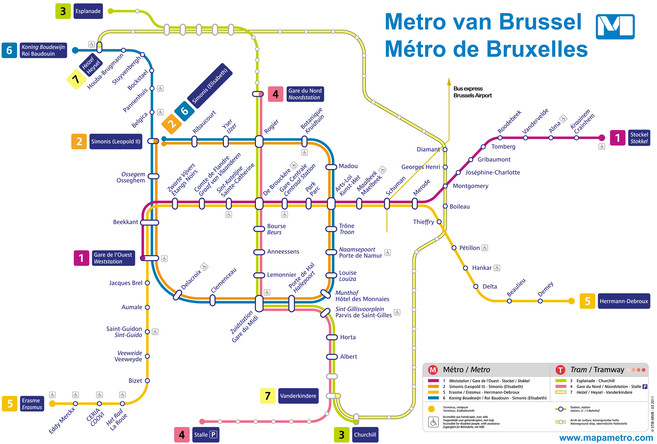
PDF version of the map: Brussels metro map (Brussels).pdf
Schedules
- Monday to Thursday: 5:30h a 0:30h
- Friday: 5:30h a 1:00h
- Saturdays: 6:00h a 1:00h
- Sundays and holidays: 6:00h a 0:30h
Brussels metro fares
Here's a quick summary of Brussels metro ticket prices. Prices are in euros and we also give an approximation in US dollars so that tourists can get an idea..
| Type of ticket | Precio (EUR) | Approximate price (USD) |
|---|---|---|
| One-way ticket | 2.10 | 2.30 |
| Round-trip ticket | 4.20 | 4.60 |
| Bill of 5 Trips | 8.00 | 8.70 |
| Bill of 10 Trips | 14.00 | 15.20 |
| Daily Ticket | 7.50 | 8.20 |
| Monthly payment | 49.00 | 53.50 |
| Annual Allowance | 499.00 | 544.00 |
Besides, to use the subway easier and faster, can you get the card MOBIB, what does it cost 5 EUR and is valid for 5 years. This card can be recharged with any of the mentioned bills.
History of the Brussels metro
The Brussels metro began in the early years 70, driven by the need to improve the growing city's transportation infrastructure.
The project was led by the Brussels Intercommunal Transport Society (STIB/MIVB), with the participation of engineers and architects such as Maurice Bral y Marcel Cools.
The first line was inaugurated on 20 September 1976, covering an initial section that connected De Brouckère and Schuman.
Since its inauguration, the subway has undergone several significant expansions:
- In 1982, Line 1B opened, extending service to the east of the city.
- In 1988, the line was completed 2, creating a ring around the center of Brussels.
- The last major expansion took place in 2009, with the extension of the Line 2 and the creation of the Line 6.
The construction companies that participated in the different phases of the project include important Belgian contractors such as Besix y Jan De Nul Group, known for their experience in large infrastructure projects.
History of the Brussels metro map
The initial design of the Brussels metro map was commissioned by the cartography and signage design office Van Doorn & C°, under the direction of graphic designers Jean-Paul Van Doorn y Marc Berthier. This inaugural map was designed to be clear and functional, facilitating the understanding of the system for local users and tourists.
Over the years, The map has evolved to adapt to metro expansions and the needs of users. In the decade of the 2000, the design company Aximedia took responsibility for redesigning the map, incorporating new technologies and more modern graphic design approaches.
The last significant map update was made in 2018, when Interpole, a renowned Belgian design agency, introduced a more stylized and accessible design, improving readability and information offered to passengers.
Additional data
The Brussels metro connects several important tourist and cultural points of the city. Among them are Atomium, the Royal Palace and the famous Grand Place. Besides, The metro network is part of the public transportation system STIB/MIVB, which includes buses and trams, providing an integrated and efficient transportation network.
The main attractions of the city of Brussels can be accessed by metro:
- Grand Place (Gare Centrale Station, Lines 1 y 5): Central square famous for its Gothic architecture and cultural events.
- Atomium (Heizel Station, Line 6): Iconic atom-shaped structure, offers panoramic views and exhibitions.
- Manneken Pis (Bourse Station, Lines 3 y 4): Bronze statue of a boy urinating, city symbol.
- Royal Palace (Parc Station, Lines 1 y 5): Official residence of the Belgian royal family, open to the public in summer.
- Royal Museums of Fine Arts (Porte de Namur Station, Lines 2 y 6): Important art collection, from the old masters to contemporary art.
- European Parliament (Schuman Station, Lines 1 y 5): Seat of the European Parliament, offers guided tours and exhibitions about the European Union.
- Mini-Europe (Heizel Station, Line 6): Miniature park with replicas of the most emblematic monuments in Europe.