Vienna metro, officially known as “U-Bahn Wien”, is the underground transportation system in the capital of Austria. Inaugurated on 25 February 1978, has grown over time, with its last extension in the year 2017.
Currently it has 5 lines, 101 stations, and covers 75 kilometres (about 46.60 miles). It is essential for the daily transportation of millions of residents and tourists visiting Vienna..
subway map
Here's the Vienna metro map. Click on the image to see it larger:
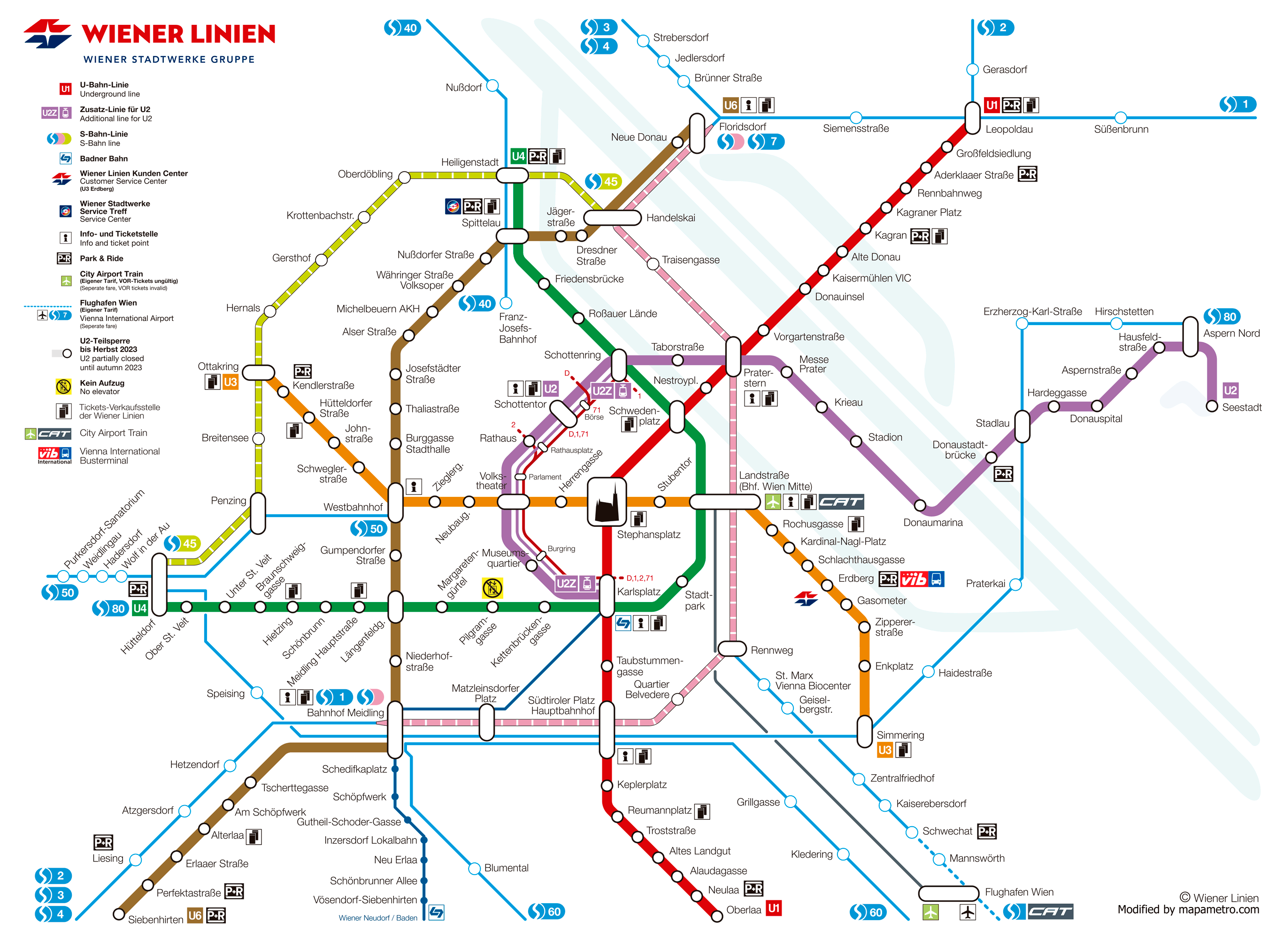
We also have the same Vienna metro map in PDF format.
Official Web site
- For more information, visit the official site of the vienna metro.
- To see a list of all tourist attractions what's in vienna, we recommend using the famous ticket website. It doesn't matter if you don't buy anything., You will see that there are very original attractions that you probably did not know about Vienna.
Vienna metro timetables
The Vienna Metro operates with the following schedules:
- Every day: of 5:00h until 00:30h.
- Friday, Saturdays and the eve of holidays: continuous service throughout the night.
Rates
The system offers the following options for passengers:
| Type of ticket | Price in EUR (USD) | Details |
|---|---|---|
| One-way ticket | 2,40 EUR (~2.63 USD) | a single trip. |
| 24h ticket | 8 EUR (~8.77 USD) | Unlimited trips for one day. |
| 48h ticket | 14,10 EUR (~15.45 USD) | Unlimited trips for two days. |
| 72h ticket | 17,10 EUR (~18.74 USD) | Unlimited trips for three days. |
History of the subway
The Vienna metro began to take shape in the years 70, Test operations began in 1976 and finally opened its doors on 25 February 1978. Curiously, Parts of lines U4 and U6 date back to the Stadtbahn (urban railway) inaugurated in 1898, which was originally designed for trams before being adapted to the needs of the metro.
Key Expansions
The first phases of expansion took place between 1969 y 1982, during which lines U1 were built, U2 y U4. Followed by this, The second phase of expansion covered lines U3 and U6, completing in the year 2000. The third phase began in 2001 and it lasted for nine years, culminating in several additional extensions.
In 2010, A fourth phase of expansion detailed in the Transportation Master Plan of 2003, including the extension of lines U1 and U2. This phase was completed in 2017, reaching a total of 89 km long with 116 stations on the network.
The last station opened on the Vienna metro is part of the U2 line. This expansion included the station Neulaa, which was opened to the public on 2 September 2017.
Innovations and contracts
Throughout its development, Companies such as Siemens have contributed with signaling and control systems, while construction companies such as Strabag They have also been involved in the realization of the different extensions of the metro.
Looking to the future, a fifth phase of expansion has been contemplated, although it is subject to the availability of financing.
Vienna Subway Map History
Vienna metro, inaugurated in 1978, has based part of its infrastructure and aesthetics on the system Stadtbahn original designed by Otto Wagner 80 years ago, in 1898.
Mr. Wagner not only contributed to the architectural design of the stations but also influenced the initial visual presentation of the transportation system, including maps and signage.
Development Through the Years
Specific documentation on individual designers is not widely available, but we found unconfirmed news, that the design of that time was the work of a team led by the transportation systems designer Kurt Kolb, who since the years 70 managed to maintain a coherent vision of the route scheme, making the map visually clear and easy to interpret.
Recent Contributions
More recently, Wiener Linien, the operating company of the Vienna subway, has continued to update and refine the map design to make it more accessible and easier to use. We have not been able to find out who the current designers are.. But it is evident that behind these graphic design efforts, there is a good dedicated professional team within Wiener Linien .
Additional data
The Vienna Metro in addition to connecting local inhabitants and tourists with their destinations efficiently, It also offers access to some of the most emblematic points of the city:
- Palace of Schönbrunn: Accessible from the metro station Schönbrunn on line U4, this palace, declared World Heritage, It is an architectural gem of Austrian imperial history.
- St. Stephen's Cathedral: The subway station Stephansplatz on line U1 leaves you in the heart of Vienna, right next to this gothic cathedral.
- Vienna State Opera: Near the metro station Karlsplatz (U1 lines, U2, U4), the famous opera house is an essential cultural landmark.
- Museum of Natural History: Near the metro station Volkstheater (lines U2 and U3), This museum houses one of the largest natural history collections in Europe.
- Vienna City Hall: From the subway station Rathaus on line U2, you can reach the majestic neo-Gothic building that houses the city's municipal offices.
Old Vienna subway maps
In historical mode, We are uploading maps from previous years to this section, in this case of the year 2014:
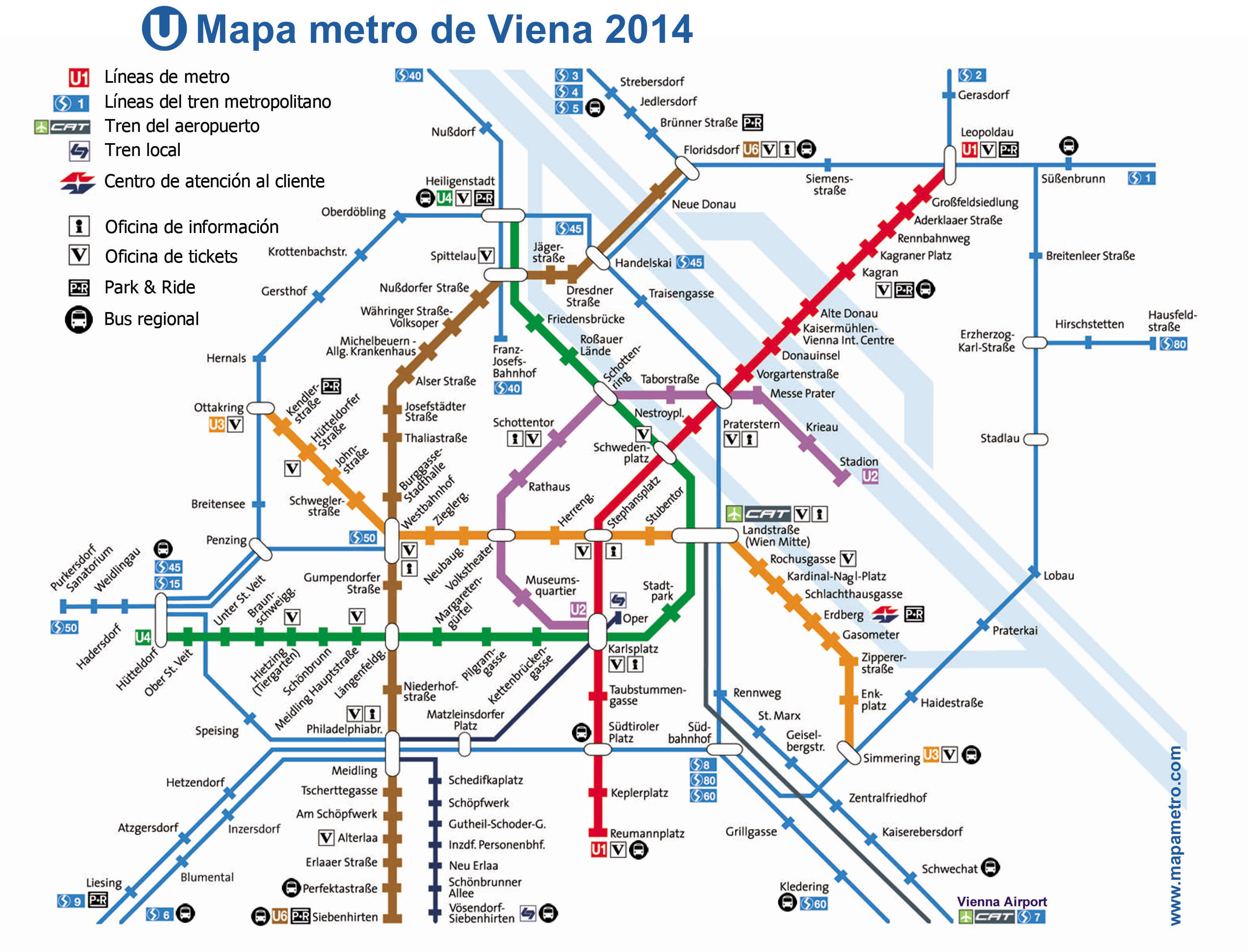
Here is the same map of the 2014 in pdf format: Vienna Metro Map.