The Ludwigshafen tram and light rail system, known as “Ludwigshafener Stadtbahn“, is part of the transport network of the Rhine-Neckar region, Germany. Inaugurated on 29 May 1969, This system is essential for urban mobility.
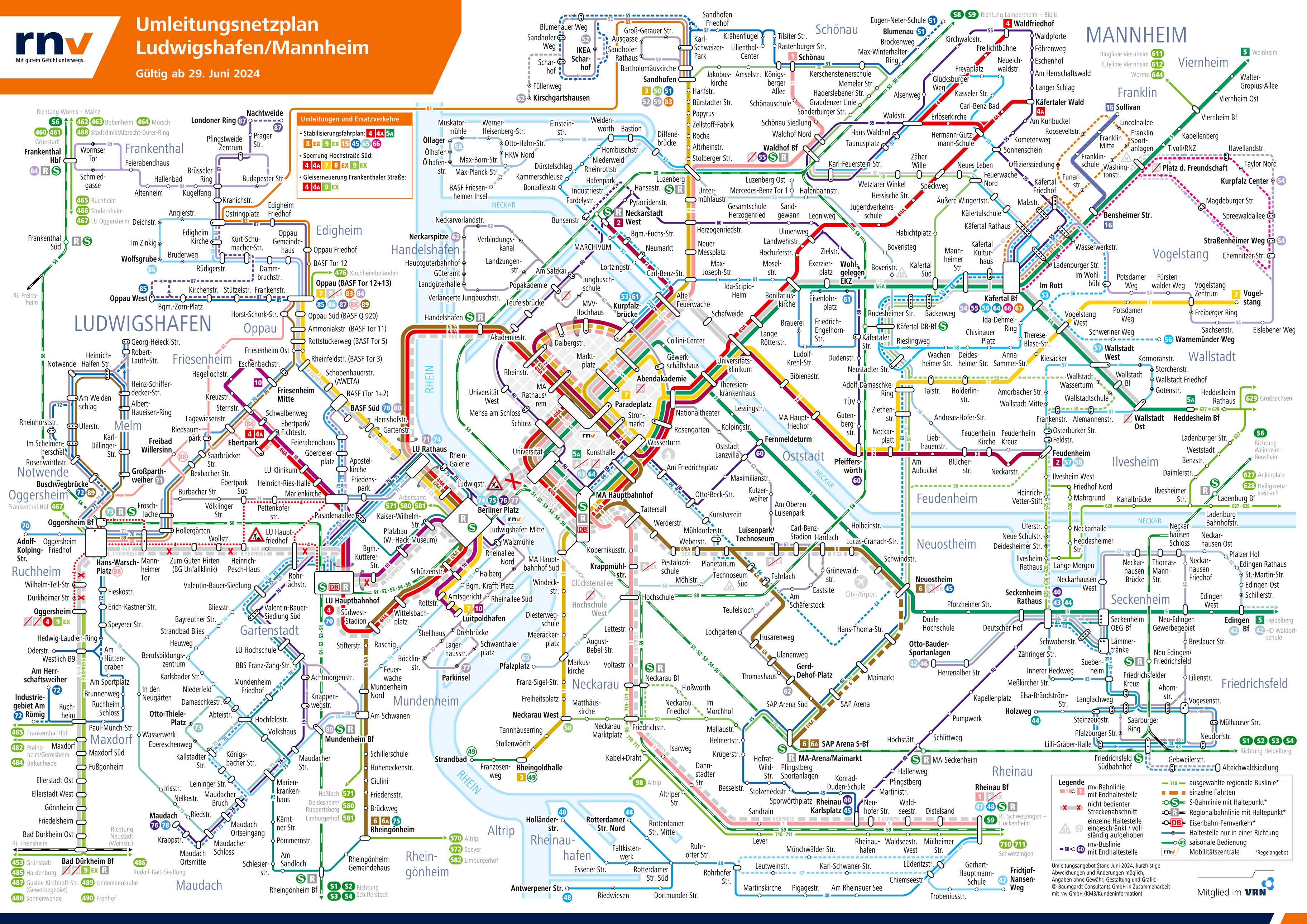
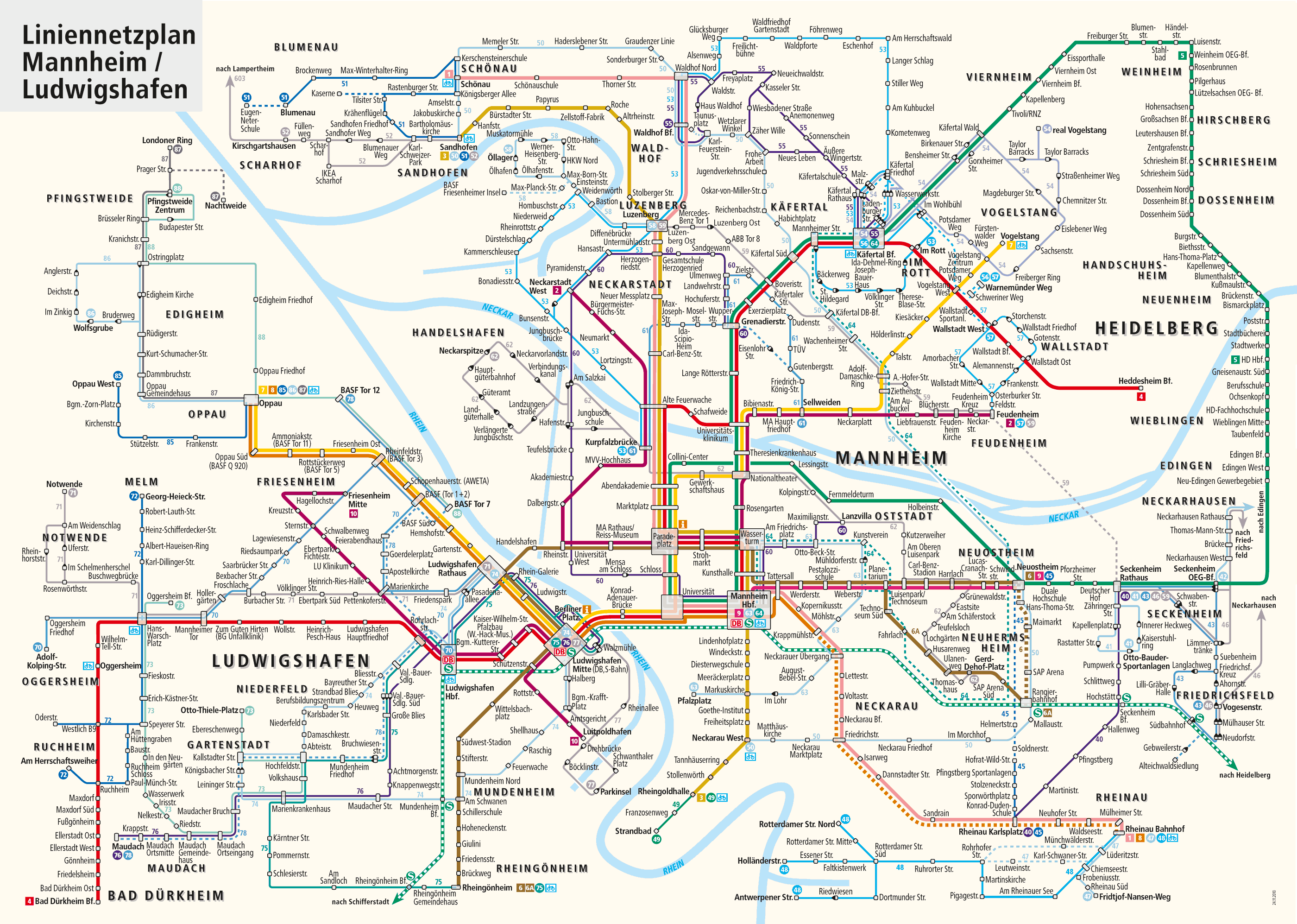
Below is the map of the transport system in Rhein-Neckar (of Mannheim and Ludwigshafen). This map includes tram lines, buses and the main transport connections operating in both cities:
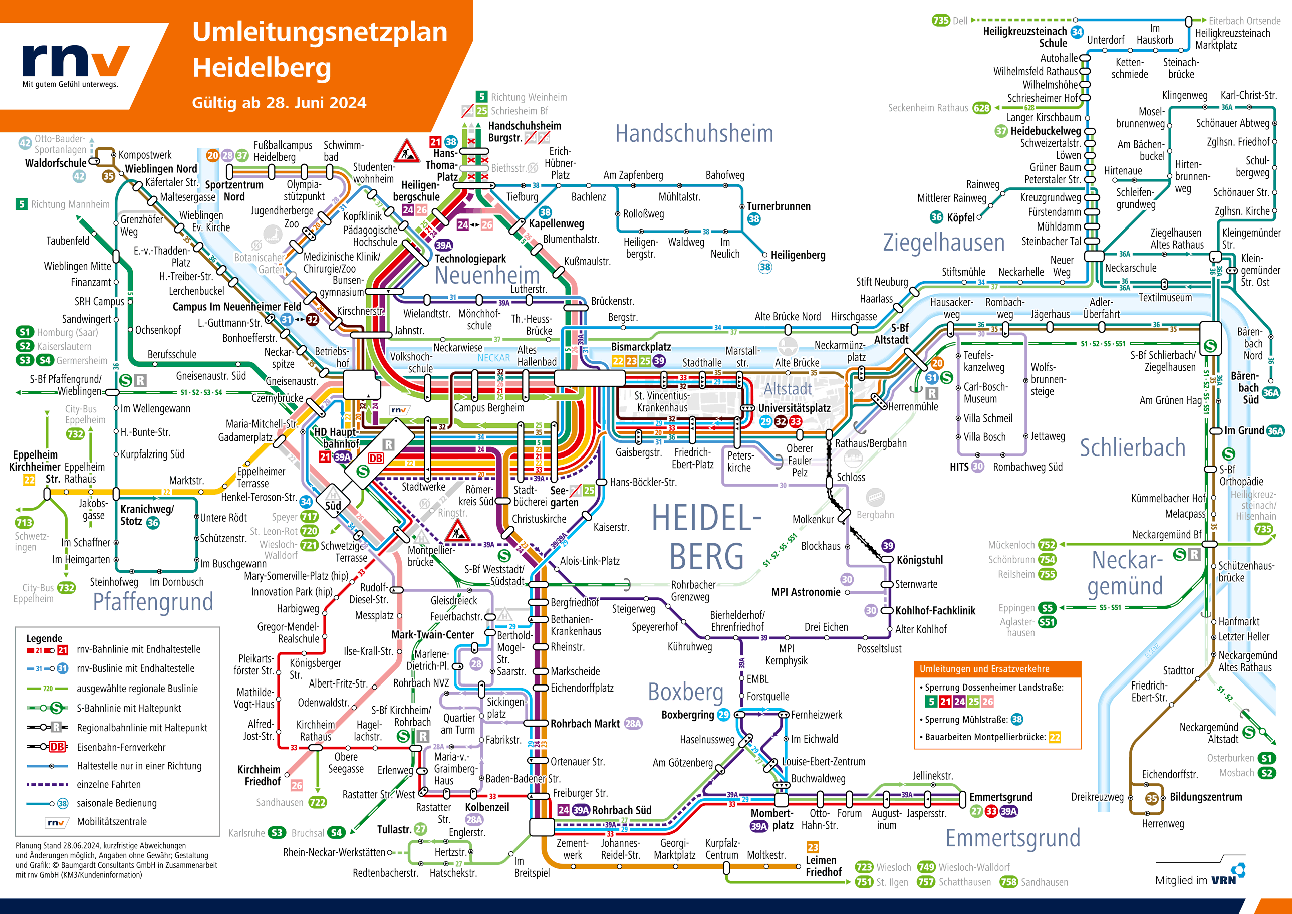
Below is the map of the Heidelberg transport system and its surroundings. This map includes tram lines, Buses and regional connections:
The transport system has several lines connecting Ludwigshafen with Mannheim and Heidelberg, facilitating the daily commute of thousands of passengers. With underground and surface routes, the Ludwigshafen tram and light rail offer a fast and efficient alternative to road transport.
In the context of Ludwigshafen, It is more correct to refer to the transportation system as a “trolley car” o “light rail”, since the Ludwigshafen system is not a complete underground metro, but a modern tram system that operates both on the surface and in underground sections.
The term “Stadtbahn Rhein-Neckar“ refers to the light rail system operating in the Rhine-Neckar region, including cities such as Ludwigshafen, Mannheim and Heidelberg. This transportation system is a combination of tram and light rail, providing an efficient and fast connection between the cities of the region.
Official Web site
- For more information, Visit the official website of the Ludwigshafener Stadtbahn: rnv-online.de
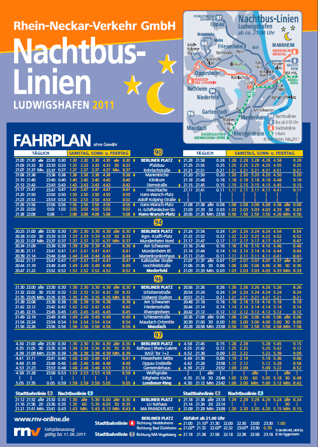
Transport schedules
Each line has its own schedule, in summary they are the following:
| Line | Work days | Saturdays | Sundays and holidays |
|---|---|---|---|
| Line 1 | 05:00 – 23:30 | 05:00 – 23:30 | 06:00 – 22:30 |
| Line 2 | 05:15 – 23:45 | 05:15 – 23:45 | 06:15 – 23:15 |
| Line 3 | 04:50 – 00:10 | 04:50 – 00:10 | 05:30 – 23:40 |
| Line 4 | 05:00 – 00:00 | 05:00 – 00:00 | 06:00 – 23:00 |
| Line 5 | 05:05 – 23:50 | 05:05 – 23:50 | 06:10 – 23:10 |
| Line 6 | 05:20 – 00:20 | 05:20 – 00:20 | 06:00 – 23:30 |
| Line 7 | 05:10 – 00:30 | 05:10 – 00:30 | 06:10 – 23:40 |
| Line 8 | 05:00 – 23:30 | 05:00 – 23:30 | 06:00 – 22:30 |
| Line 9 | 05:15 – 00:00 | 05:15 – 00:00 | 06:15 – 23:30 |
| Line 10 | 05:00 – 23:00 | 05:00 – 23:00 | 06:30 – 22:00 |
For specific times of each stop and possible changes in schedules, It is recommended to consult the official website of Rhein-Neckar-Verkehr (RNV) and use the app Start.Info for real-time updates.
Rates
The Ludwigshafener Stadtbahn offers a variety of tickets to meet the needs of different types of passengers. Next, A table is presented with the main prices of banknotes in euros and their equivalent in US dollars.
| Type of ticket | Precio (EUR) | Precio (USD) |
|---|---|---|
| One-way ticket | 2,50 EUR | 2,74 USD |
| Day ticket | 7,00 EUR | 7,67 USD |
| Monthly payment | 80,00 EUR | 87,69 USD |
| Ticket 4 trips | 9,60 EUR | 10,52 USD |
| weekly ticket | 25,00 EUR | 27,40 USD |
Besides, There are several cards and passes with special discounts:
- Tourist card: Offers unlimited rides during 24 o 48 hours, Ideal for visitors who want to explore the city without transportation worries.
- Student pass: Significant Student Discount, allowing them to travel at a reduced cost.
- Senior season ticket: Available for people over 65 years, with reduced fares to make your daily commute easier.
- Family season ticket: Allows families to travel together at a discount, Making public transportation more affordable.
For more information and to buy tickets online, You can visit the official site of Rhein-Neckar-Verkehr (RNV).
History of the Ludwigshafener Stadtbahn
The evolution of the Ludwigshafen tram and light rail system, known as “Ludwigshafener Stadtbahn“, is the result of decades of planning, Construction and technological development. Below is a timeline of the most important events:
decade of 1960
- 1967: The first plans for the construction of an underground tram system were initiated (U-Strab) in Ludwigshafen and Mannheim.
- 1969: Inauguration of the new Ludwigshafen Central Station and the first section of the U-Strab, connecting the station to the old centre via a tunnel.
decade of 1970
- 1970: The company Züblin AG construction of the C-Tunnel, that would connect the Hauptbahnhof with the Rathaus.
- 1971: The consultants Pampel y Grabe recommended the construction of a system of U-Stadtbahn, but Ludwigshafen decided to continue with the U-Strab due to the infrastructure already under construction.
- 1976: Inauguration of the C-Tunnel, allowing a fast connection between the main points of the city. This section was one of the first to operate in an underground network.
decade of 1980 y 1990
- 1980-1990: Regular map updates to include new stations and lines. Graphic designers Peter Schmidt y Karin Müller were responsible for several of these updates.
- 1987: New underground and surface sections were introduced to improve system efficiency and reduce traffic congestion.
decade of 2000
- 2005: The company Rhein-Neckar-Verkehr GmbH (RNV) assumed the operation of the tram and light rail system in the region of Rhein-Neckar.
- 2008: Closing of the C-Tunnel due to changes in transportation needs and economic viability.
Currently
At the moment, the responsibility for creating and maintaining the maps of the Ludwigshafen tram and light rail system lies with Rhein-Neckar-Verkehr GmbH (RNV). This company is in charge of operating and managing the entire public transport system in the region of Rin-Neckar, which includes the cities of Mannheim, Ludwigshafen and Heidelberg.
RNV not only handles the day-to-day operations of transportation, but also responsible for the preparation and updating of route maps, ensuring that they are accurate and reflect the latest modifications and expansions of the system.
As of today (year 2024), the last Ludwigshafen metro station to open was the Friesenheim Ebertpark. This station opened on 12 December 2008 as part of the improvements and expansions of the urban transport system.
History of the map Ludwigshafener Stadtbahn
The development of the Ludwigshafen metro map began in the 1980s. 1960, when the first underground lines began to be laid as part of the project U-Strab, Designed to combine the features of trams and metros. The engineers Walter Grabe and the consulting company Pampel were key in the early planning phases, proposing a system of underground trams that over time would become the Stadtbahn what we know today.
During the years 70, the construction of the C-Tunnel, that connected the Hauptbahnhof with the Rathaus, It was an important milestone. This project, led by local engineers and supported by several construction companies in the region, It marked the first major expansion of the underground system. The construction company Züblin AG played a crucial role in the construction of the tunnels, while the design firm Vössing Engineering developed the first maps and schemes of the subway routes.
In 1976, with the inauguration of the C-Tunnel, An updated map reflecting the new underground connections was presented. This map was designed by a team of cartographers led by Hans-Dieter Schumann, who worked for the Ludwigshafen Public Transport Office.
In the years 80 y 90, Maps were regularly updated to include new stations and lines. Graphic designers Peter Schmidt y Karin Müller were responsible for several of these updates, ensuring that the map was not only functional but also aesthetically appealing. Local printing companies, as Druckhaus Mannheim, they were in charge of producing and distributing the physical maps, that were placed in stations and carriages for the convenience of passengers.
Digitalization has also played an important role, with interactive maps available on the official website and in mobile applications developed by the transport company Rhein-Neckar-Verkehr (RNV).
Additional data
Ludwigshafen, headquarters of the multinational chemical company BASF, benefits greatly from the Ludwigshafener Stadtbahn. This tram system facilitates daily commuting for employees and reduces traffic and pollution in the city.
Besides, the tram is a comfortable option for tourists visiting places such as the Museum Wilhelm-Hack and the Park Ebert, making your visits more enjoyable and accessible. This is the list of the main tourist places in Ludwigshafen:
- Katzinett – Katzenmuseum Ludwigshafen (Rhein-Galerie, Line 6): Exhibit the history of cats in art and daily life.
- Rhein-Galerie (Berliner Platz, Line 4): Shopping center with variety of shops and restaurants, located by the river.
- Wildpark Rheingönheim (Rheingönheim, Line 8): Animal park that houses European species in a natural environment.
- Wilhelm-Hack-Museum (Berliner Platz, Line 4): Museum of modern art with permanent and temporary exhibitions.
- Ebertpark (Ebertpark, Line 6): Sprawling urban park with gardens, Trails and Recreation Areas.
- BASF Besucherzentrum (BASF, Line 7): Visitor Center of the World's Largest Chemical Company, Showcasing innovations.
- Ernst-Bloch-Zentrum (Rathaus, Line 4): Cultural center dedicated to the philosopher Ernst Bloch, with exhibitions and events.
- Staatsphilharmonie Rheinland-Pfalz (Pfalzbau, Line 4): Regional symphony orchestra with regular concerts and cultural events.
Old maps
In historical mode, We are posting in this section the old maps, in this case of the year 2014. Click on the following maps Metro, to see larger images:
Download high resolution image above (formato PDF): ludwigshafen-light rail-map.pdf
Fuentes: Hiekumme Hämkumme, Wikipedia – The free encyclopedia, Fahrplan Bus Bahn, Mapa Metro, UrbanRail y RNLF.