Frankfurt subway, officially known as “Frankfurter U-Bahn”, is the underground transportation system that operates in the city of Frankfurt, Germany.
Inaugurated on 4 October 1968, The system has gone through several expansions, with the last one made in 2010.
At the moment, the metro has 9 lines that cover 86 stations, along 65 kilometres (about 40.39 miles). It is a vital network for the daily mobility of residents and tourists in the city..
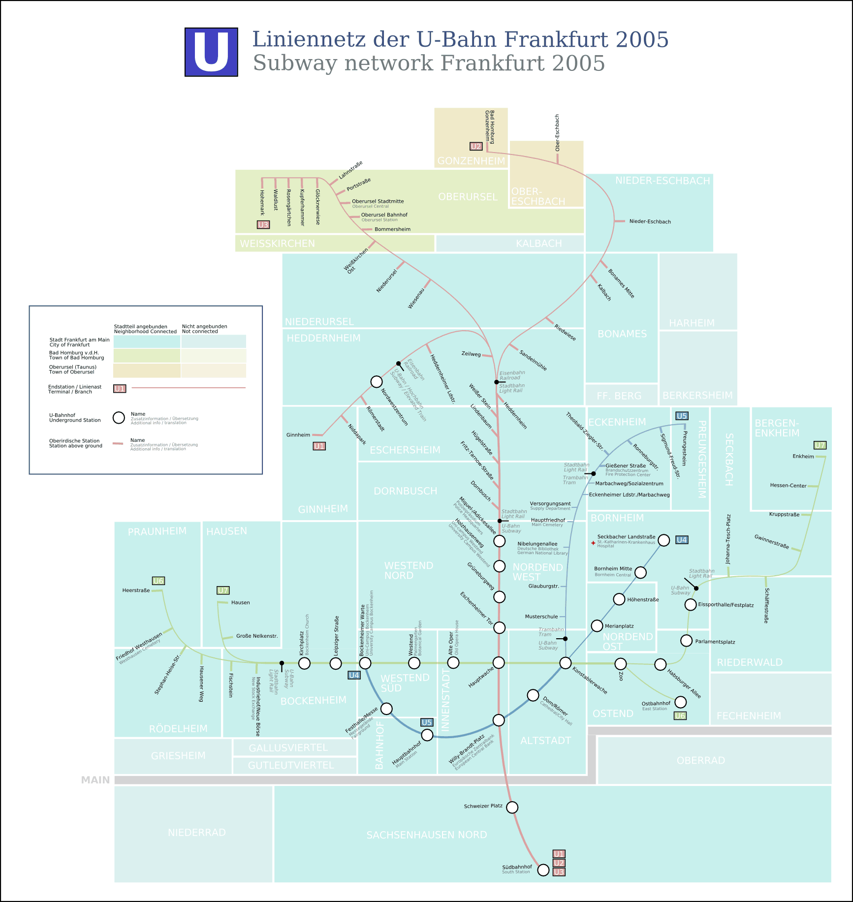
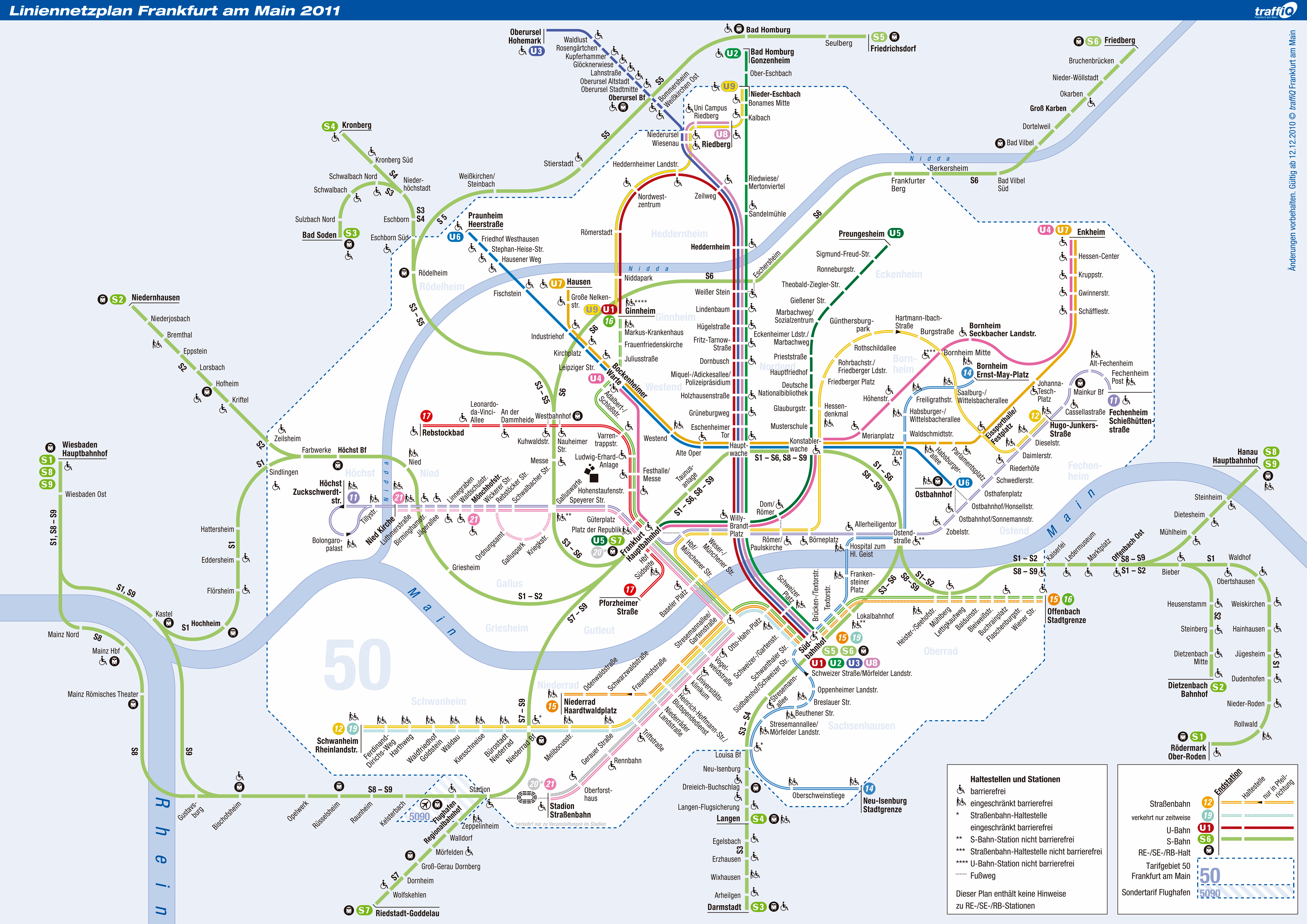
Below we show you several Frankfurt subway maps:
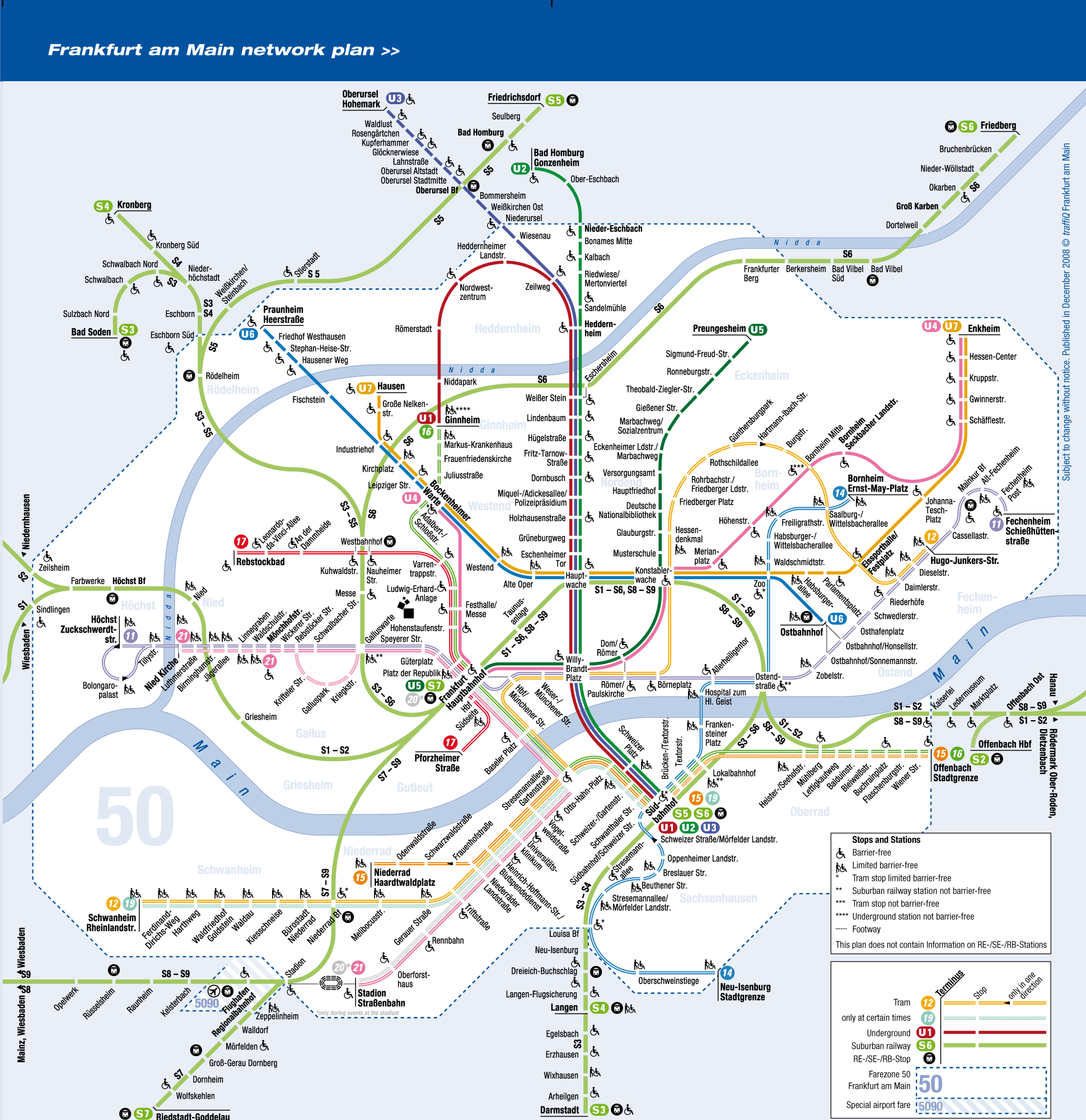
The previous map in PDF format: traffiQ_Liniennetzplan_2011.
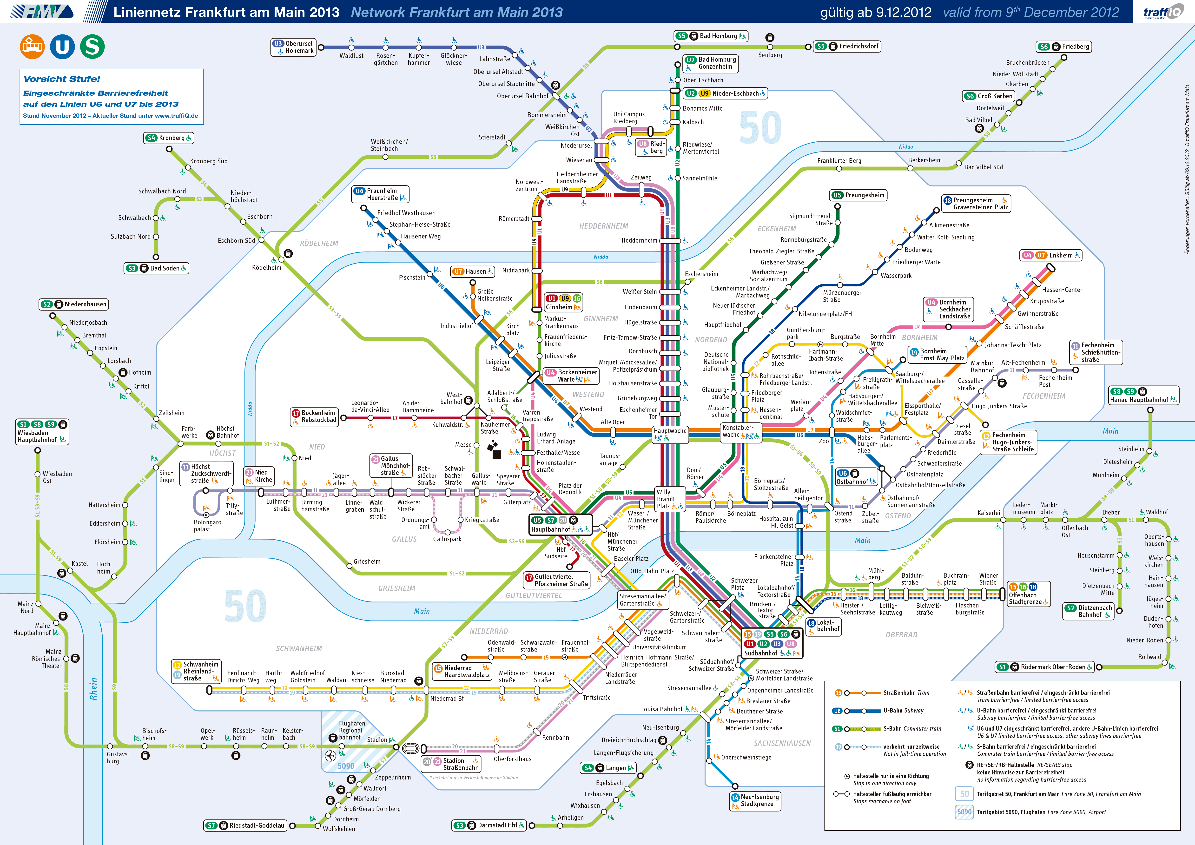
The same previous map, but in PDF format: MAPA-oficial-traffiQ_Liniennetzplan_2013.
Metro timetable
The Frankfurt metro operates with the following schedules:
- Every day: of 4:00h until 1:00h.
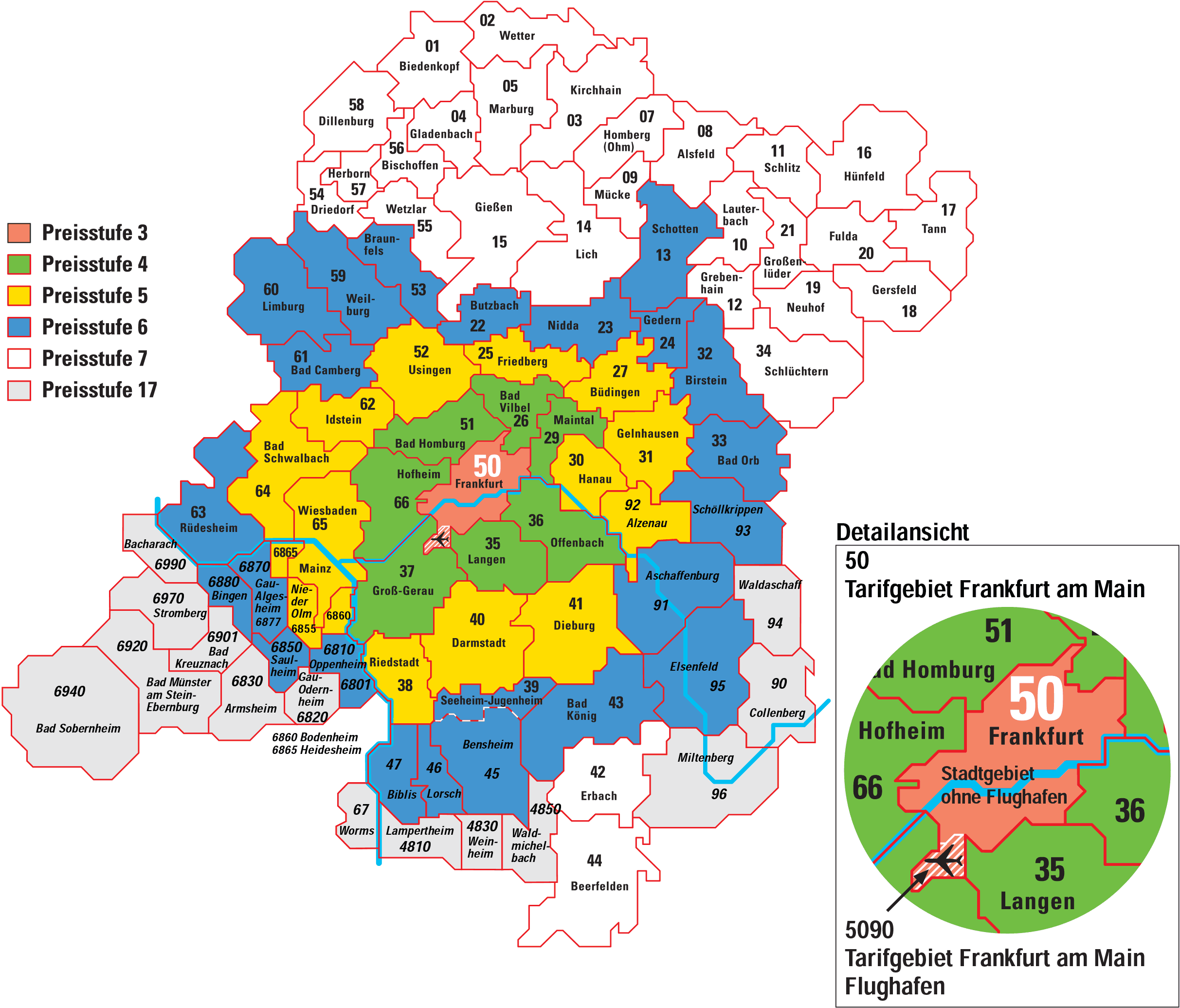
Frankfurt subway fares 2024
On the Frankfurt subway system, Rates are structured to suit different needs. In addition to single ticket options (Single ticket) and day ticket (daily ticket), there are other alternatives:
- One-way ticket:
- Individual trip for one trip: 3.40 EUR.
- day ticket (daily ticket):
- Offers unlimited rides for one day: 5.87 EUR.
- Germany ticket:
- By 49 EUR monthly, allows you to travel throughout Germany with any means of regional transport, including Frankfurt metro.
- Discount available for residents with the Frankfurt-Pass.
- SparPass:
- A monthly pass that grants a 25% discount on individual and daily tickets for adults.
- time tickets (Time cards):
- Includes weekly passes, monthly and annual with discounts for groups and companies.
The pricing system seeks to serve different types of passengers, from occasional travelers to frequent users who want to get around the city economically.
Official Web site
For more information, visit the official site of the Frankfurt metro.
Complete list of tourist attractions in Frankfurt in the popular Ticket sales website. In addition to discovering new options, you can buy tickets in advance, avoiding long lines, bad weather and, sometimes, get a discount 20%
History of the subway
Frankfurt subway (U-Bahn) began operations in 1968, with the opening of its first line between Hauptwache and Nordweststadt. This work was developed in response to the growing need for more efficient public transportation to replace trams., they were overloaded.
Initial plans for the system date back to the 1990s. 1950, when various alternatives were discussed, including a full underground subway, a tram line with underground sections (Light rail) and an elevated train. Finally, A U-Bahn was chosen, which would initially be a light rail system with underground sections in the center, with a view to becoming a full metro in the future.
Development began with the construction of line A in 1963. The first route, which was inaugurated in 1968, It comprised five underground stations in the city center and connected to the new underground terminal in Nordweststadt. During the years 70 y 80, the network experienced substantial growth with extensions to the northwest, the east and the south. In particular, The connection under the River Main to the district of Sachsenhausen was inaugurated in 1984, including Schweizer Platz station.
Frankfurt's U-Bahn network has grown to include nine lines, covering 86 stations and connecting various neighborhoods and suburbs. Careful planning allowed the incorporation of underground sections in the center and at-grade or elevated sections in the suburbs, giving the system a unique combination of metro and light rail features.
The system is currently managed by the company Verkehrsgesellschaft Frankfurt (VGF) under the framework of the Rhein-Main-Verkehrsverbund association (RMV). In the last decade, The network has been modernized to meet resident demand and reduce congestion on local roads, transporting more than 130 million passengers annually.
History of the Frankfurt subway map
The design of the Frankfurt metro map has followed its own line of evolution, reflecting the increasing complexity of the network. In its early stages, The maps were simple diagrams showing the few operational lines. One of the first designers to shape the graphic structure of the map was Otl Aicher, a renowned German designer known for his work on iconography for the Munich Olympic Games in 1972. His minimalist approach pioneered the clear representation of routes.
Over time, as new lines and stations were added, The map design was updated to include more information, ensuring clear and easy guidance for passengers. Designers such as Hartmut Esslinger contributed in more recent years to maintaining the map's modern and understandable aesthetic., which today shows a network of routes interconnected with other modalities of public transport, including trams and regional trains.
The Frankfurt metro map has also been influenced by intermodality with the S-Bahn (suburban train) and the extensive urban bus network. The different lines are coded by color and number to facilitate navigation for residents and visitors, integrating the network in a logical way for everyone.
Additional data
The Frankfurt subway not only offers efficient mobility, but also connects passengers to some of the city's most notable points of interest:
- Römerberg (Dom/Römer Station): The heart of the old town, with historic buildings and the iconic Römer, town hall headquarters.
- Museum of Modern Art (Dom/Römer Station): A major museum housing a notable collection of contemporary art.
- Main Tower (Willy-Brandt-Platz Station): This skyscraper offers stunning panoramic views of Frankfurt and its surroundings.
- Städel Museum (Schweizer Platz Station): An art gallery exhibiting collections from the Middle Ages to contemporary times.
- Palmengarten Botanical Garden (Bockenheimer Warte Station): A vast park that displays a great diversity of flora.