Munich subway, officially known as “Münchner U-Bahn”, is the underground transportation system in the city of Munich, Germany.
It opened 19 October 1971, and has gone through numerous expansions with the latest in 2010. Currently it has 8 lines that cover 102 stations, and has a length of 103.1 kilometres (about 64.06 miles).
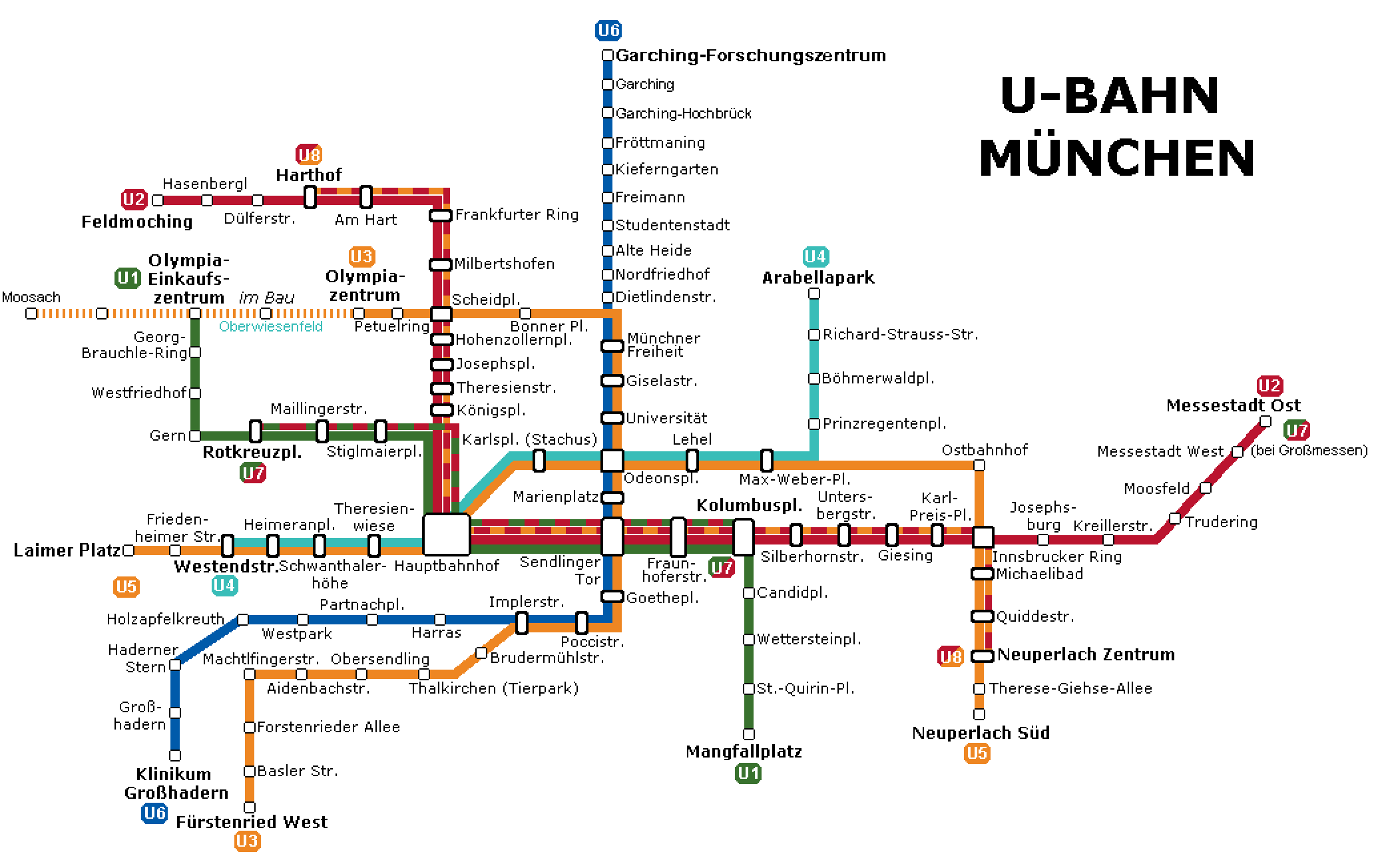
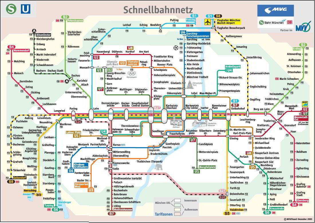
subway map
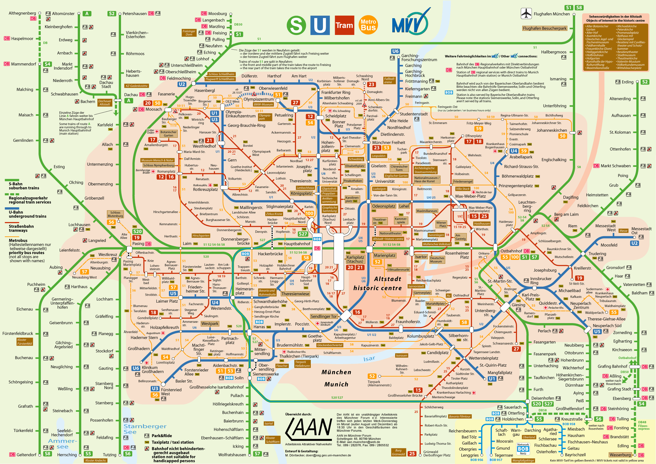
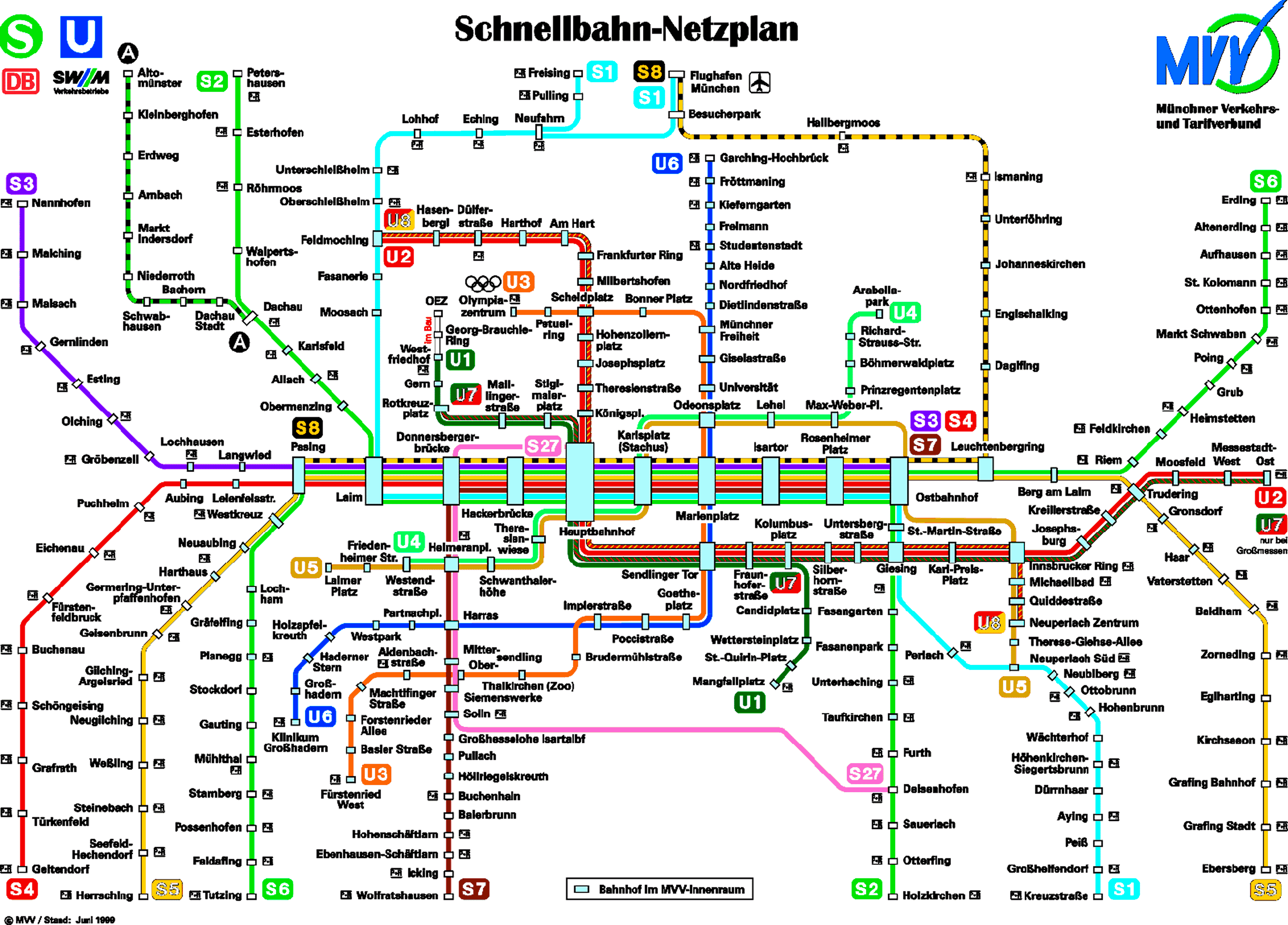
Here's the Munich subway map in four different versions, click on any image to see it larger.
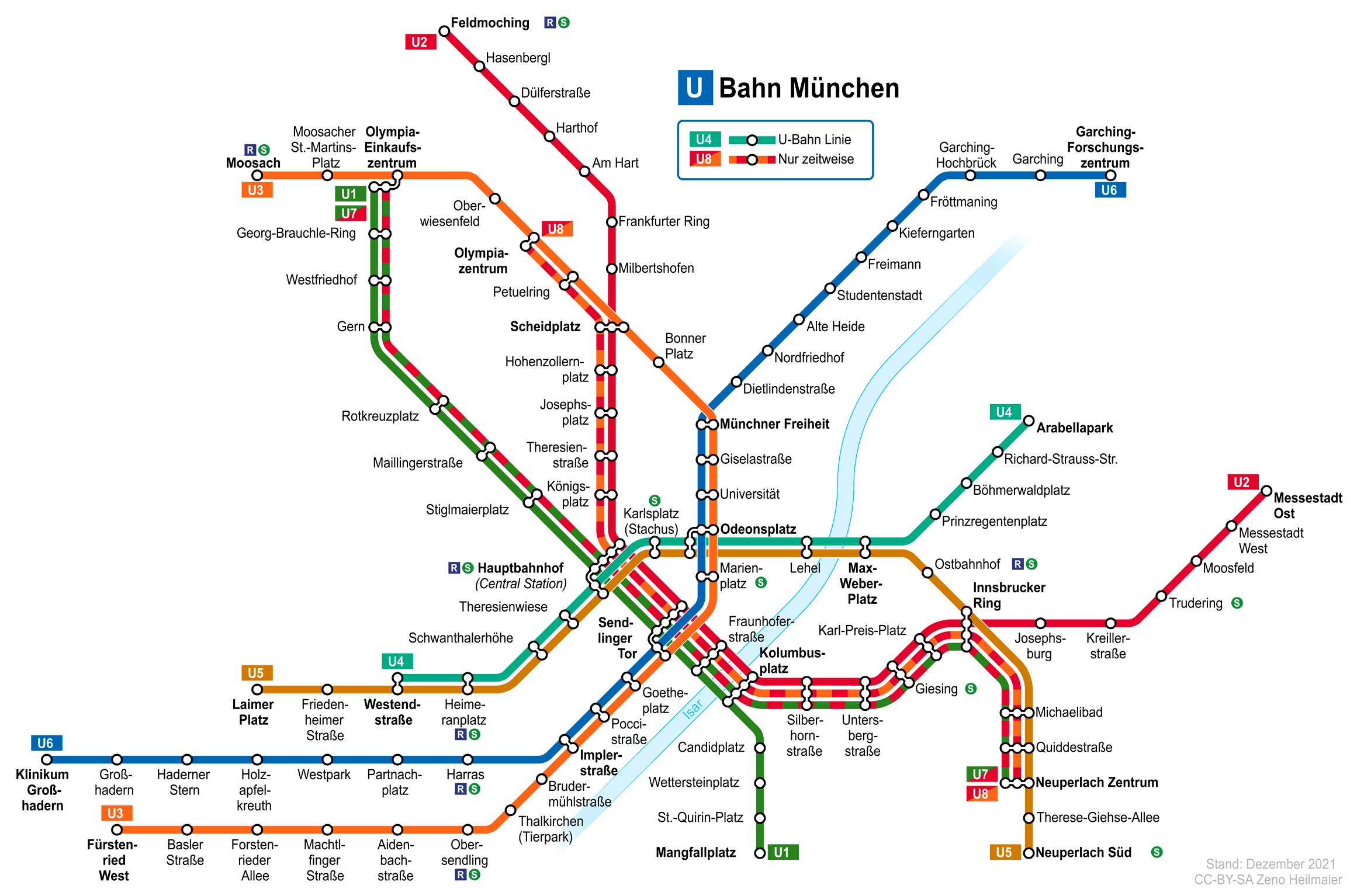
First map (U-Bahn from Munich): This map focuses exclusively on the Munich subway network (U-Bahn), showing lines U1 to U8. The lines are clearly differentiated by color and numbered, facilitating the identification of routes and connections between them. Does not include other means of public transportation such as S-Bahn the trams:
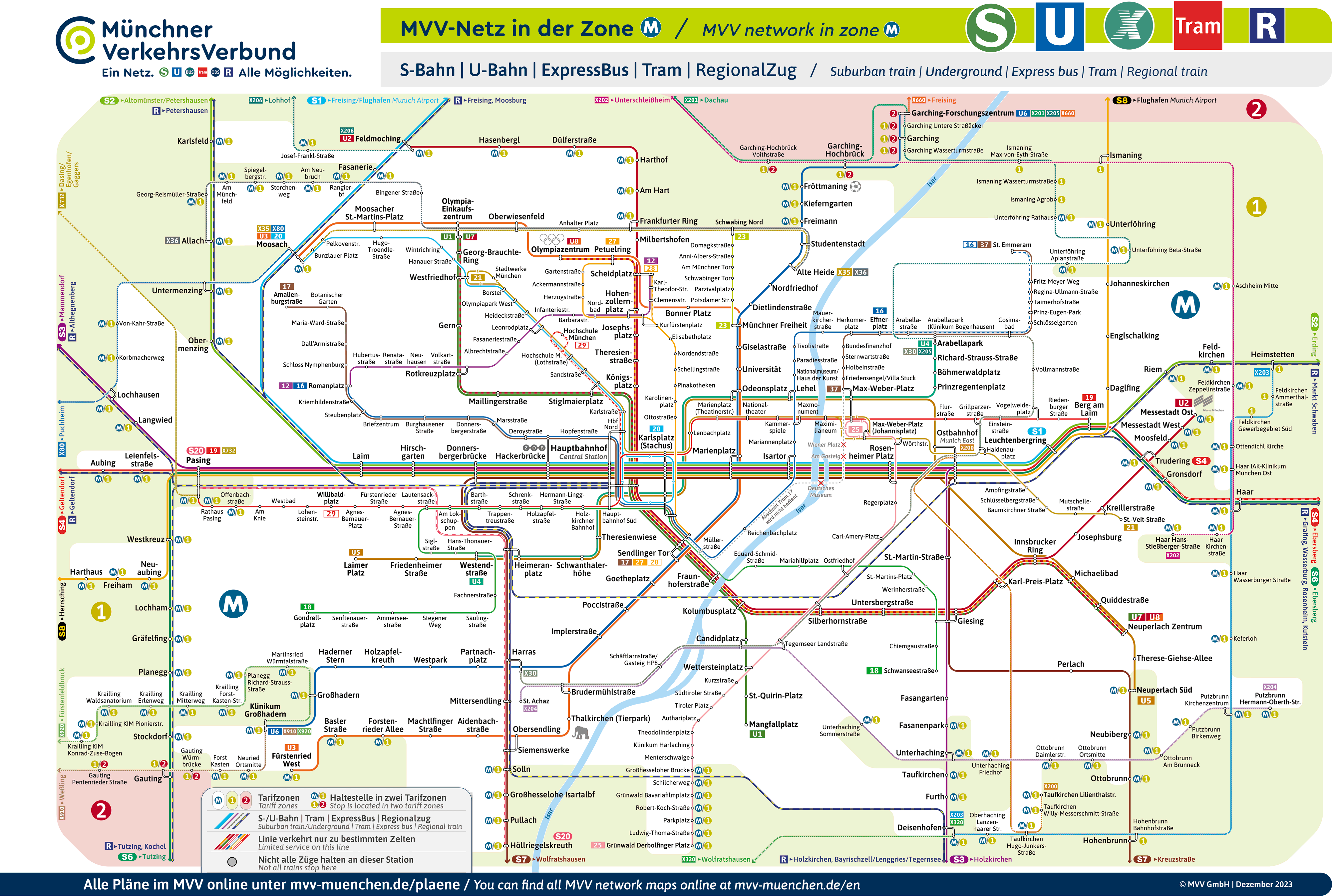
Second map (MVV-Netz in der Zone M): This map is more complete and includes both the metro (U-Bahn) like the suburban train (S-Bahn), in addition to regional train lines and express buses. It is designed to show all transport options within the central area of Munich (Zona M). This map is useful for passengers who need to transfer between different forms of public transportation within the city:
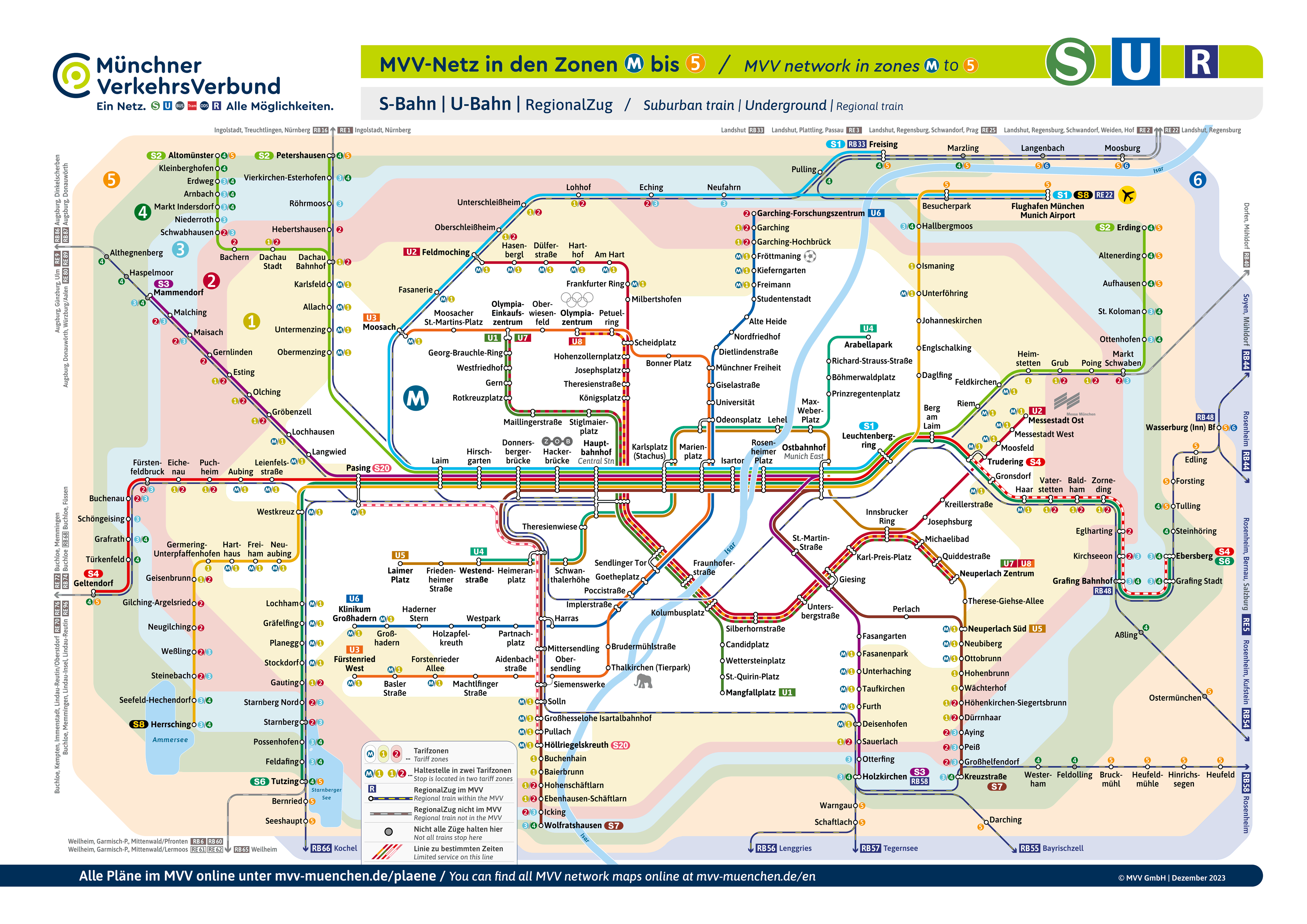
Third map (MVV-Netz in zones M to 5): Similar to the second, This map also shows the public transport network, but expands coverage to include five rate zones, covering larger areas around Munich. Includes the S-Bahn, U-Bahn, and regional services, providing a broader view of the transportation system for those traveling to or from the suburbs:
Fourth map (MVV-Netz in den Zonen M bis 1 bis 11): This is the largest map and covers up to eleven fare zones. Provides a comprehensive overview of the transport system in and around Munich, including all means mentioned in the previous maps. It is ideal for users who need to understand the connections between the central city and more distant regions, including nearby cities and major tourist destinations:

Schedules
The Munich subway operates with the following schedules:
- Every day: of 4:00h a 1:00h.
Rates
Munich's transport system offers a variety of fare options tailored to different travel needs. Here I provide you with a table with the main ticket prices, expressed in euros and their equivalent in US dollars (USD), based on ticket type and number of travel zones:
| Type of ticket | Zones | Precio (EUR) | Precio (USD, approx.) |
|---|---|---|---|
| One-way ticket | 1 Zone | 3.40 | $3.65 |
| One-way ticket | 2 Zones | 6.50 | $7.00 |
| Day Ticket | M Zone | 8.90 | $9.60 |
| Day Group Ticket | M-6 | 25.60 | $27.50 |
| Weekly Card | M Zone | 18.90 | $20.30 |
| Monthly Card | M Zone | 57.10 | $61.40 |
Cards and Special Offers
Munich also offers special cards and discounts that can be especially useful for tourists and frequent travelers.:
- Munich Card: Provides unlimited rides and discounts up to 70% in more than 100 main attractions of the city. Available to individuals and groups for periods of 24 a 120 hours.
- Bayern Ticket: Ideal for groups, allows unlimited travel on regional trains throughout Bavaria for one day, with a base cost for the first person and an additional price for each additional adult up to a maximum of five.
- Deutschland Ticket: Offers unlimited travel on regional trains throughout Germany with a monthly subscription cancelable at any time.
These rates and offers provide flexibility and added value, allowing visitors to explore Munich and its surroundings economically and conveniently.
For more details on fares and to purchase tickets, you can visit the official site of MVV (Münchner Verkehrs- und Tarifverbund).
Official Web site
- For more information, visit the official site of the munich subway.
- Or you can consult the Complete list of tourist attractions in Munich.
History of the subway
The idea of a subway in Munich dates back to the beginning of the 20th century, but it was not until the decade of 1960 that the plans began to come true.
The 1 February 1965 It was the official start of the construction of the subway with the first blow of the shovel on the site of what would be the station Nordfriedhof. This symbolic act was carried out by the then Minister-President of Bavaria, Alfons Goppel, and the Mayor of Munich, Hans-Jochen Vogel (Munich subway).
Expansion accelerated by the Olympic Games
The Olympic Games 1972 to Munich they accelerated the works, and required rapid expansion of the network to meet transportation needs during the event. This period of accelerated construction culminated in the opening of the first subway lines just before the games.. The first line, la U6, started operating in 1971, connecting Kieferngarten with Goetheplatz.
Organization and operation
The Münchner Tunnel-Gesellschaft mbH, created in 1965, played a crucial role in financial coordination and project planning, ensuring the acquisition of funds and supervision of construction. This organized approach allowed us to overcome many technical and bureaucratic challenges, ensuring that the metro was not only built, but that it expanded efficiently in the following decades. It is currently the backbone of public transport in Munich.
summarizing
1965: The 1 February, the first blow of the shovel is made on Ungererstraße, marking the official start of construction of the Munich subway.
1971: The first metro line, la U6, The 19 October 1971, connecting Kieferngarten with Goetheplatz.
1972: Metro expansion accelerated due to Munich Olympics. Detailed planning and accelerated construction allowed for the opening of new lines and stations to better serve visitors and residents during the games.
History of the Munich Subway Map
The original Munich subway map was designed by a local team of engineers and cartographers led by Horst Spörl. This first design of 1971 it only showed the two foundational lines, U1 and U6, and was focused on a clear and simple representation to facilitate its use by passengers.
During the decade of 1980, under the direction of the Münchner Verkehrsgesellschaft (MVG), the map was modernized to include not only metro routes, but also other modes of transport such as trams and buses. This integration sought to offer a complete view of the mobility options available to travelers in the city..
In recent years, The map has undergone several redesigns to improve its readability and functionality. A notable project was led by designer Amy Weiss, who focused on improving the usability of the map and complementing it with a mobile application. This redesign sought to simplify the visual information and aesthetically adapt it to the personality of Munich., using a very bright color palette, and an intuitive icon system for easy navigation.
Additional data
The Munich subway offers direct access to many of the city's most emblematic points. Here are some key stations next to nearby attractions:
- Marienplatz (U3, U6): It connects with the historic square that houses the New Town Hall and its famous carillon, as well as the Cathedral of Our Lady.
- Odeonsplatz (U4, U5): Offers easy access to the English Garden, one of the largest urban parks in the world, and to the Munich Residence.
- Fröttmaning (U6): The closest stop to Allianz Arena, Bayern Munich stadium.
- Nymphenburg (U1): For lovers of history and art, It is the most convenient station to visit the Palace of Nymphenburg, a majestic palace complex.
- Olympiazentrum (U3): Located near the Olympic Park and the BMW Museum, a fascinating experience for car enthusiasts.
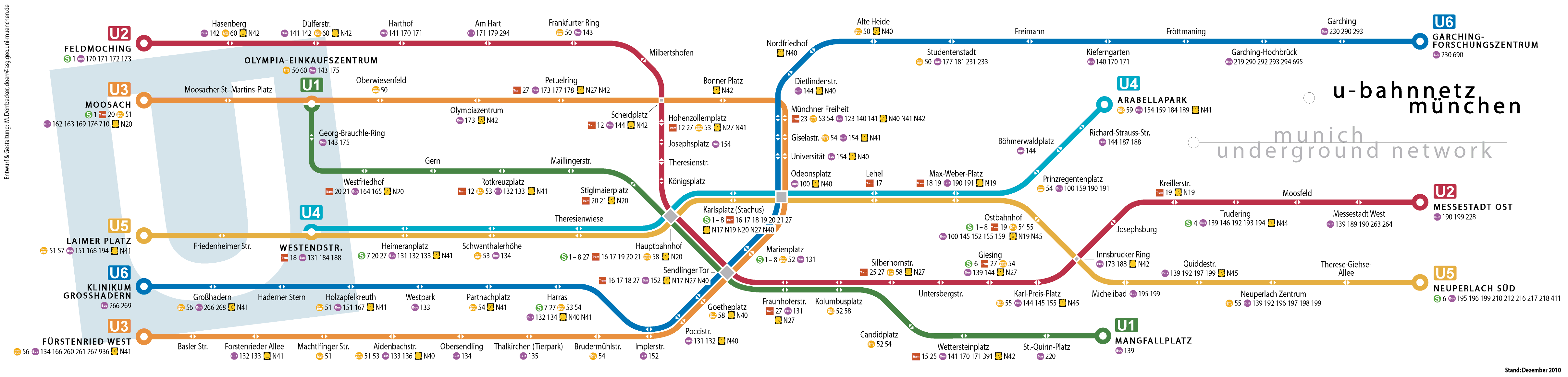
Old subway maps
In historical mode, We hang old Munich subway maps here, of the year 2015 and previous:
You can download the previous map in PDF version and in high resolution: Munich-metro-map-schnellbahnnetzplan.pdf.