The Vancouver SkyTrain is an underground and elevated transportation system that operates in the city of Vancouver, Canada.
Inaugurated on 3 January 1986, has gone through several expansions, with the last one made in 2016. At the moment, It has three lines that add up to a total of 53 seasons and cover 79.6 kilometres (about 49.46 miles).
Although it is sometimes called “Vancouver Metro”, it's a automated light rail system. It gets its name because most of its infrastructure is elevated, allowing for panoramic views as you travel above the city streets and avenues. Being on elevated roads, looks “float” in the sky. Besides, some sections are also underground, allowing uninterrupted circulation.
This system is essential for the daily mobility of residents and tourists, providing access to different areas of Vancouver and the metropolitan region.
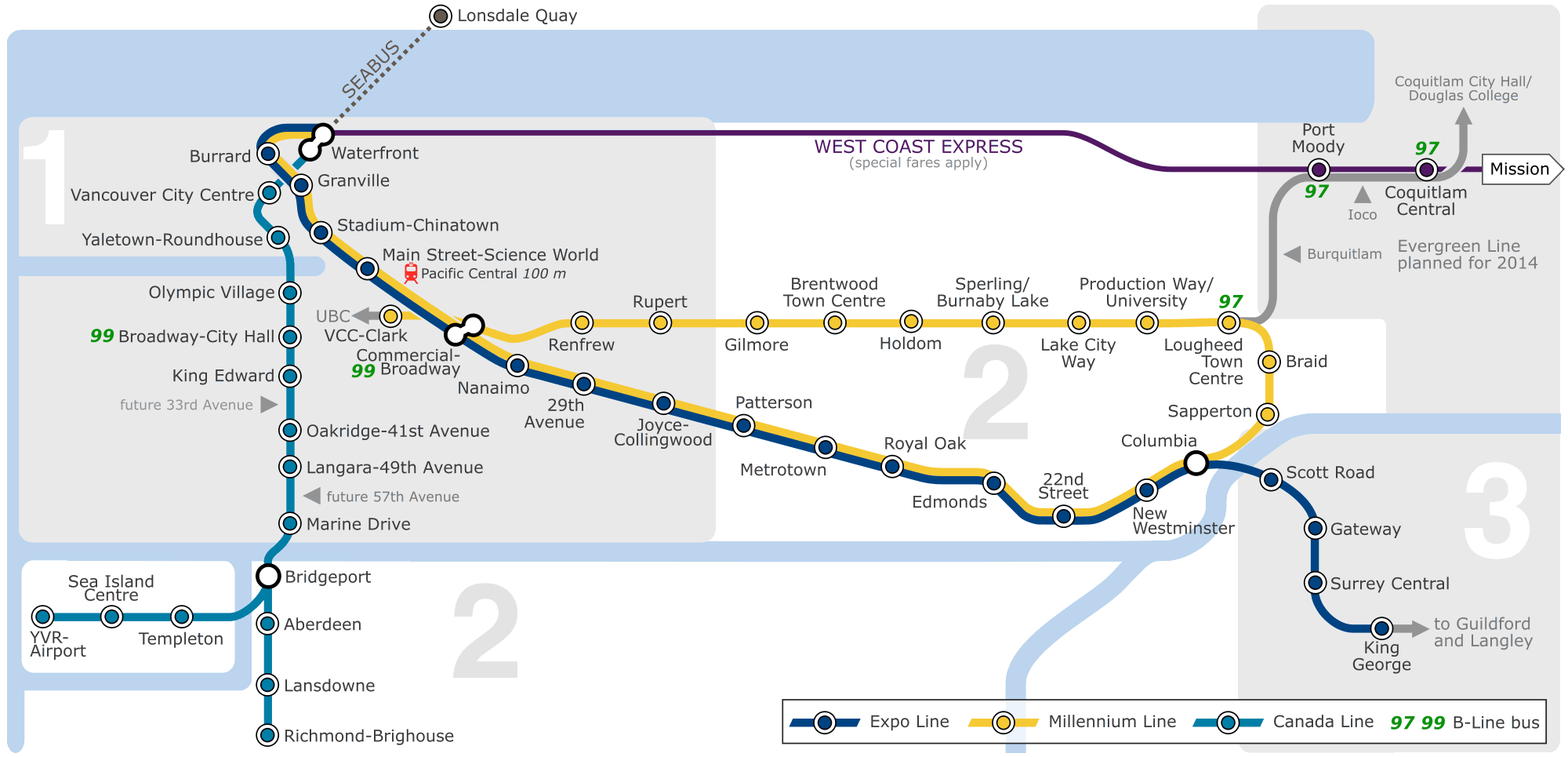
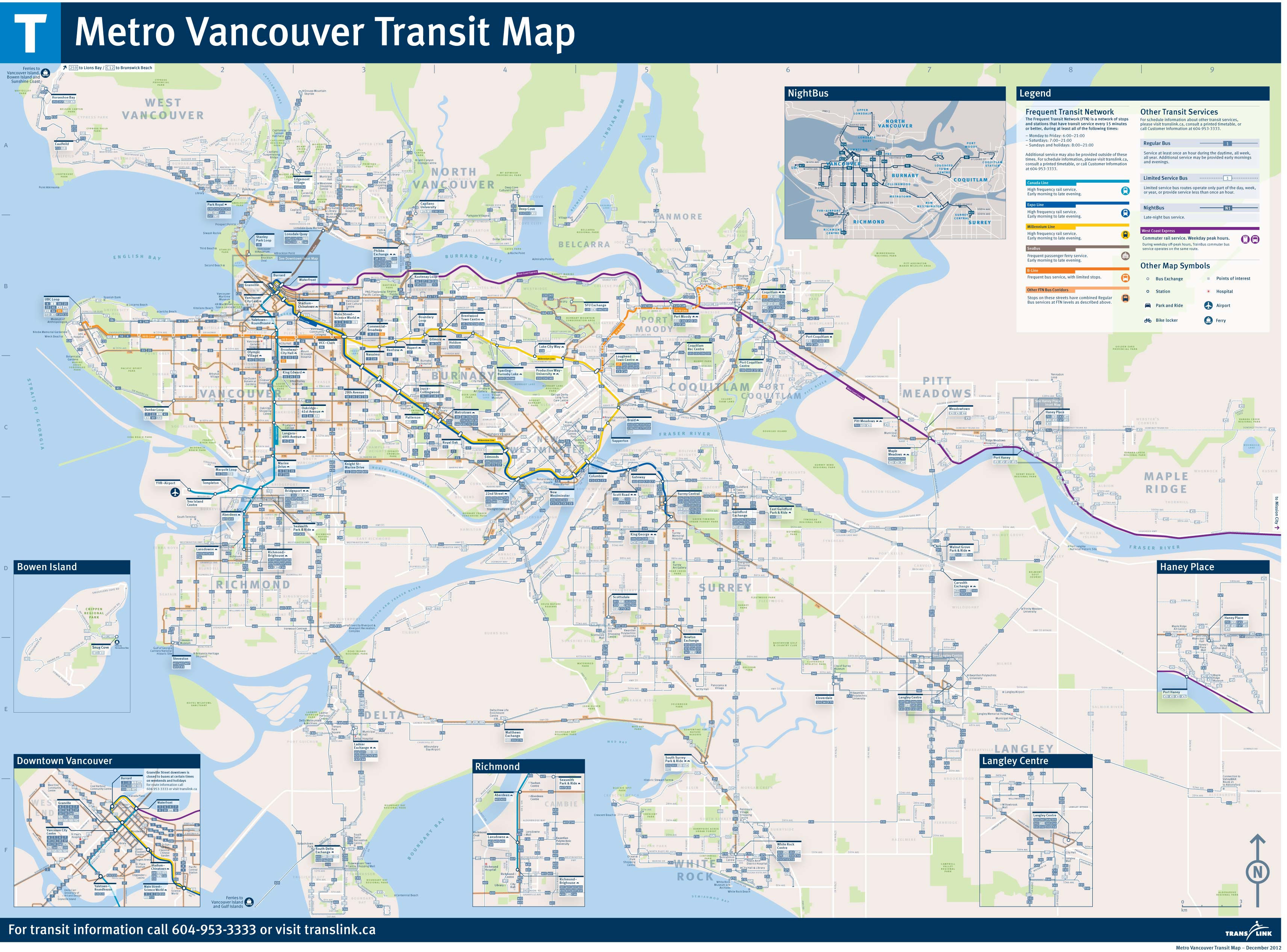
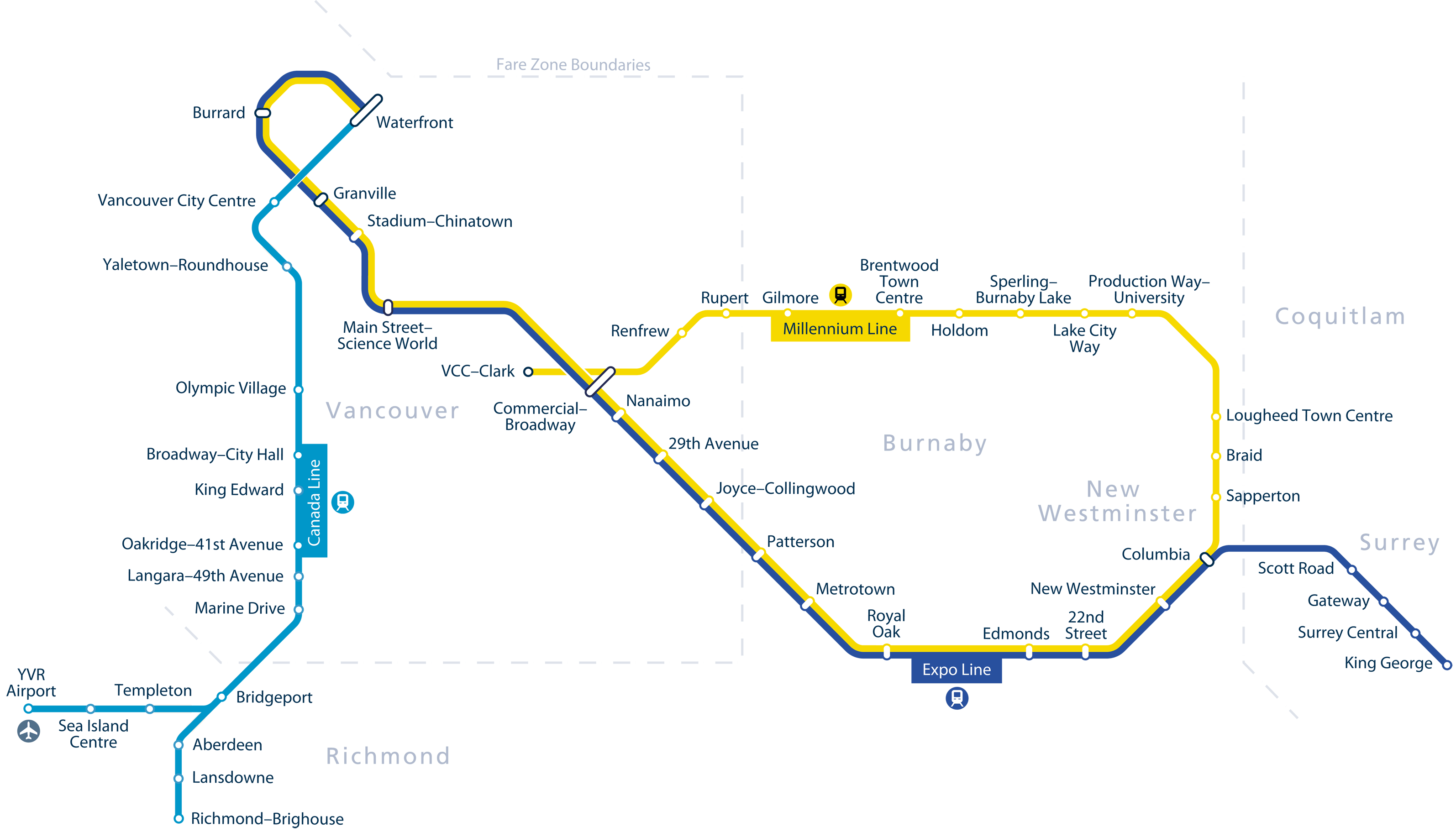
Metro Map
Below we show you the map of the Vancouver SkyTrain:
Schedules
The Vancouver SkyTrain operates with the following schedules:
- Work days: of 5:00h a 1:00h.
- Saturdays: of 5:00h a 1:00h of the next day.
- Sundays and holidays: of 6:00h a 0:00h.
Rates
The system offers several options for passengers:
- One-way ticket: 2.95 CAD (~2.17 USD) for a single trip.
- DayPass: 11 CAD (~8.09 USD) for unlimited rides for one day.
Official Web site
For more information, visit the Vancouver SkyTrain Official Site.
Website with the complete list of tourist attractions in Vancouver in the popular ticket sales website. In addition to discovering new options, you can buy tickets in advance, avoiding long lines, bad weather and, sometimes, get a discount 20%.
History of the Vancouver SkyTrain
Vancouver's SkyTrain is a notable milestone in Canadian public transportation, initially inaugurated as part of Expo '86. The Expo Line, the first to work, revolutionized urban mobility in Vancouver, connecting its inhabitants to the city center and establishing a solid foundation for future expansion. Since then, The evolution of the system has been marked by meticulous planning and a constant commitment to innovation. With the addition of the Millennium Line in 2002, the SkyTrain expanded into the eastern suburbs, increasing its network to serve a growing population in Burnaby, New Westminster y Coquitlam. The Canada Line, inaugurated in 2009, spread the network further, linking Vancouver with Vancouver International Airport and the city of Richmond.
The SkyTrain has been a pioneer in the implementation of advanced technology in driverless trains, standing out for its automated operation that allows a fast and efficient service frequency. In addition to its main lines, The system has continued to expand to serve new urban areas and meet the demands of a growing city, demonstrating a commitment to sustainability and continuous improvement.
History of the SkyTrain map
The SkyTrain map has evolved over time to reflect the transformation and growth of the transportation system.
In the first days, the map was simple, focused solely on the Expo Line, with limited but effective connections to the heart of Vancouver. As the Millennium Line and Canada Line were added, The map was adapted to illustrate the growing complexity of the network and its connection with other modes of transport..
One of the most important names in this evolution is Ken Sutherland, a graphic designer who worked extensively on modernizing SkyTrain maps. His approach was based on visual clarity and simplicity, ensuring that passengers could easily understand routes and connections.
The map's clarity and distinctive style have become a symbol of the system's accessibility, allowing both residents and tourists to navigate the city with ease. More recent editions have incorporated interactive digital elements and real-time updates.
Additional data
Vancouver's SkyTrain is not only an efficient transportation system, but also a gateway to some of the city's most impressive attractions:
- Stanley Park (Burrard Station): This station connects visitors to the iconic park that features scenic trails and a unique mix of nature and cultural activities..
- Granville Island (Yaletown-Roundhouse Station): A short distance from this station is the bustling market and arts center, offering a unique culinary and cultural experience.
- Anthropology Museum (UBC Loop Station, bus access): Although it is not directly connected to the SkyTrain, The museum can be accessed via buses from the nearest station, highlighting the rich cultural heritage of the indigenous peoples of the region.
- Gastown (Waterfront Station): The station serves as a portal to one of Vancouver's oldest historic neighborhoods, famous for its steam clock and modern boutiques.