The Hanover city tram (officially called “Stadtbahn Hannover“) is a tram system that operates in Hanover, Germany. It is not really considered an urban metro, but rather an urban tram that is part of the country's railway system.
This system, inaugurated on 29 September 1975, has 12 lines, y 196 stations distributed throughout 121 kilometres (75 miles).
Below we show you the urban tram map and other maps, that may interest you. Click on the image to see it larger.
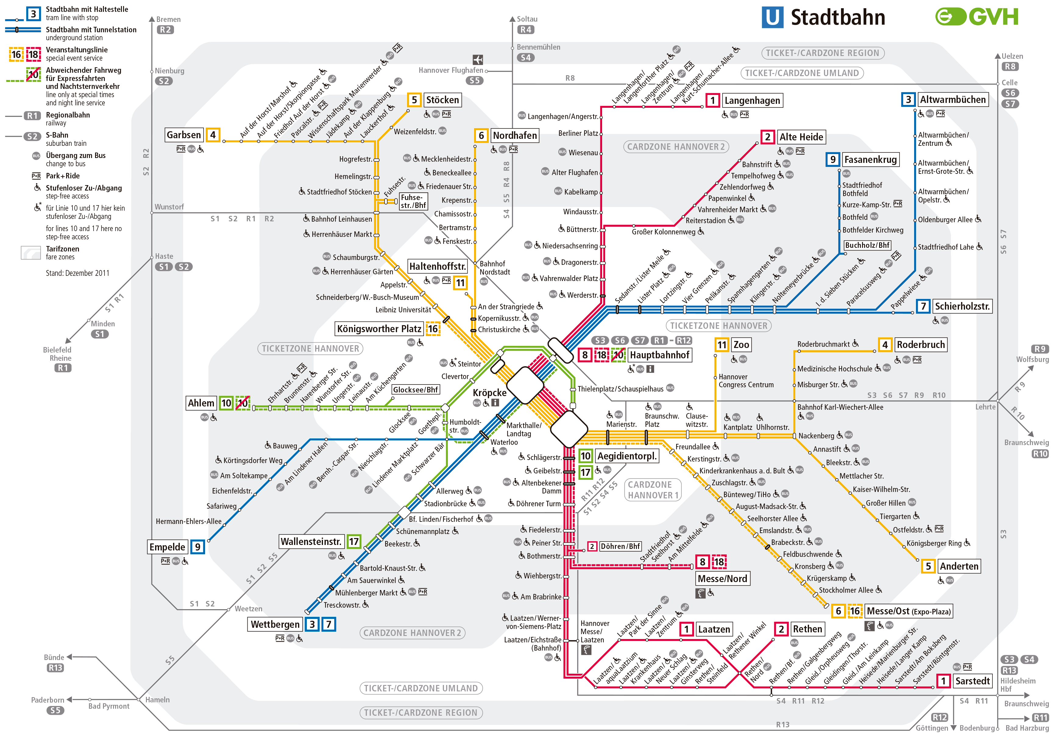
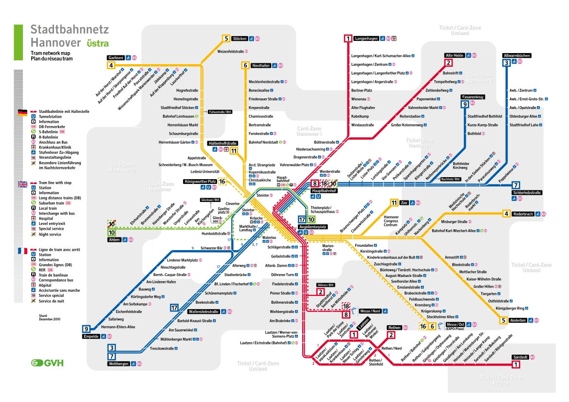
Urban tram map from Hanover:
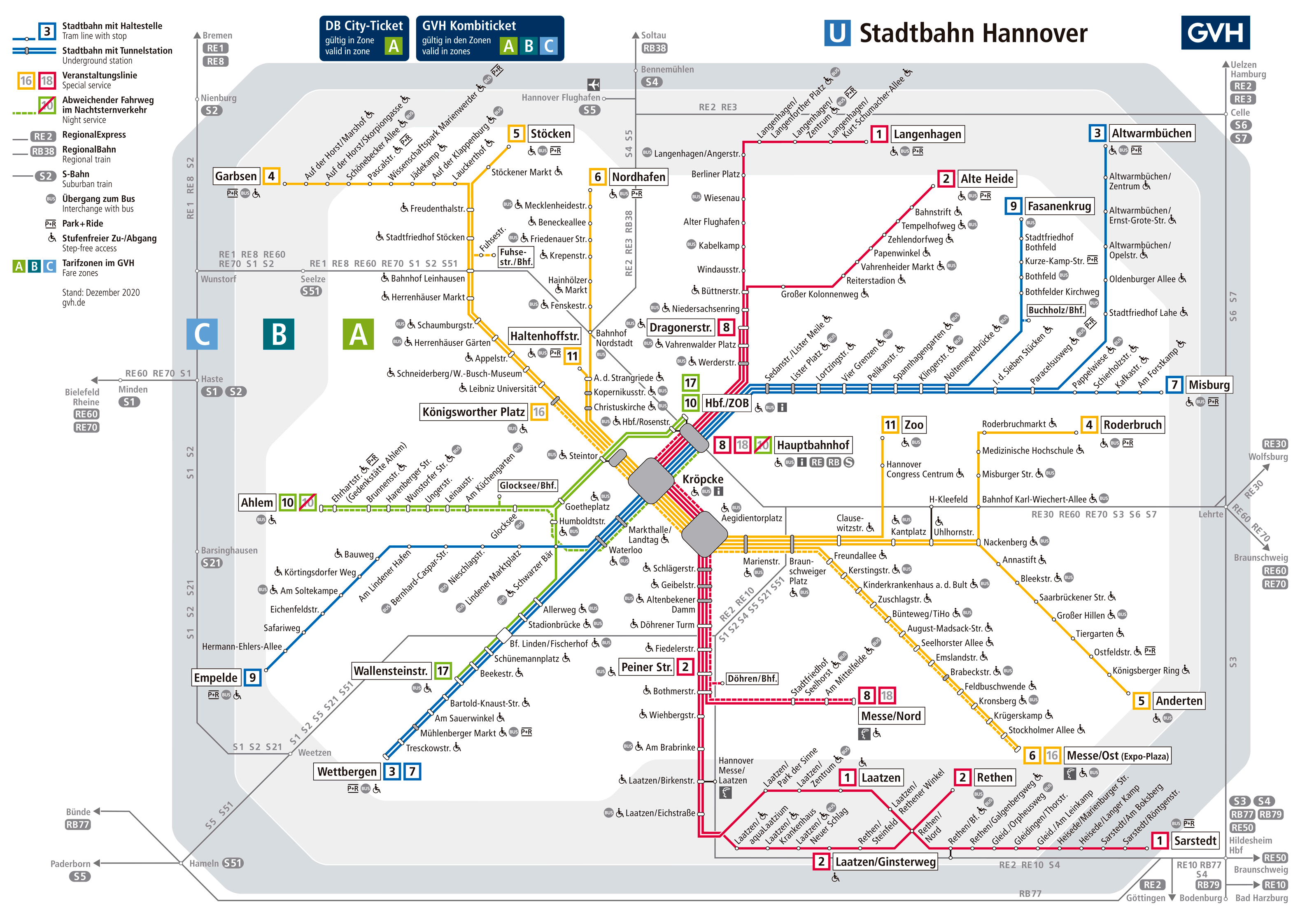
The previous map in PDF format.
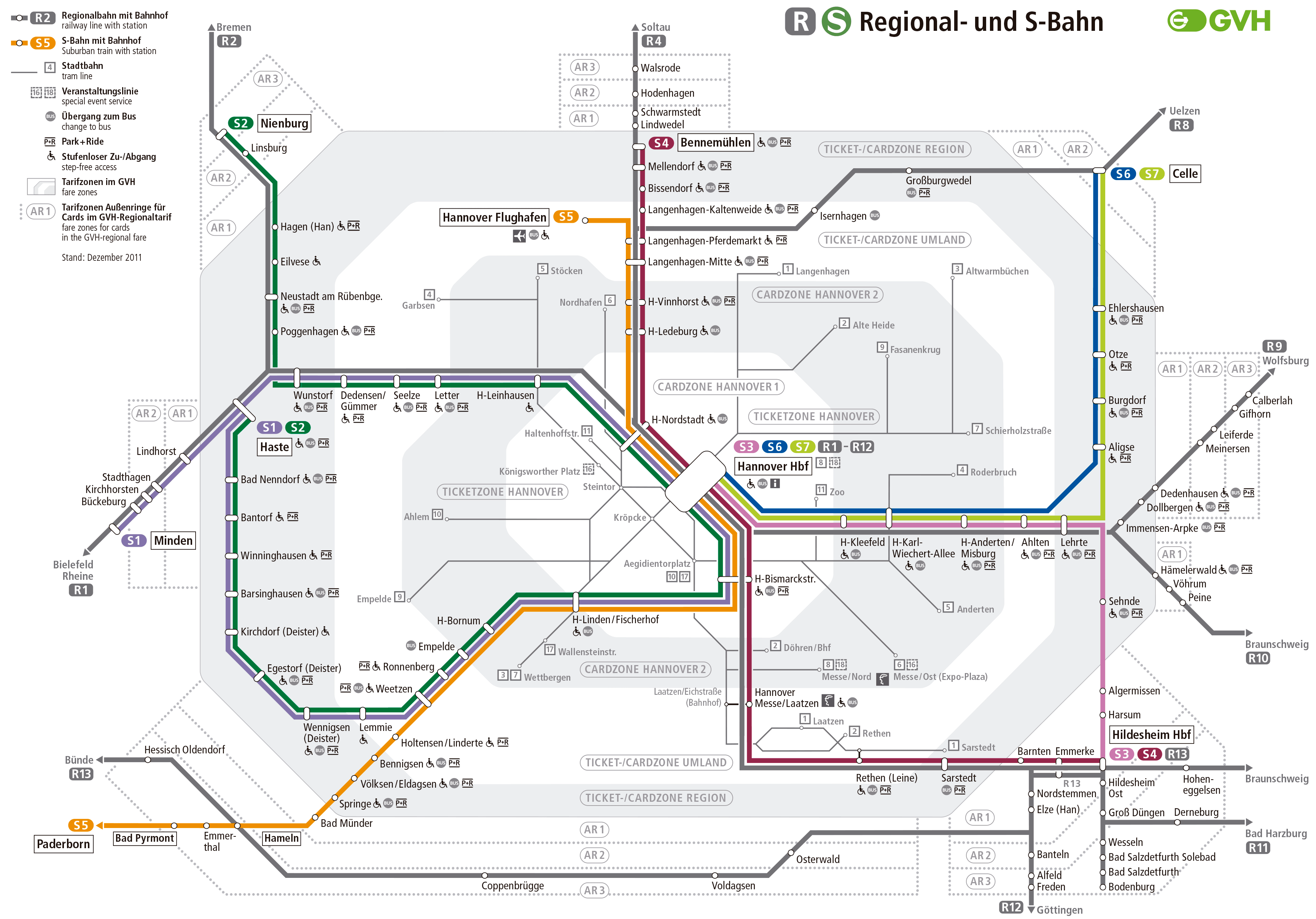
Regional train and S-Bahn map from Hanover:
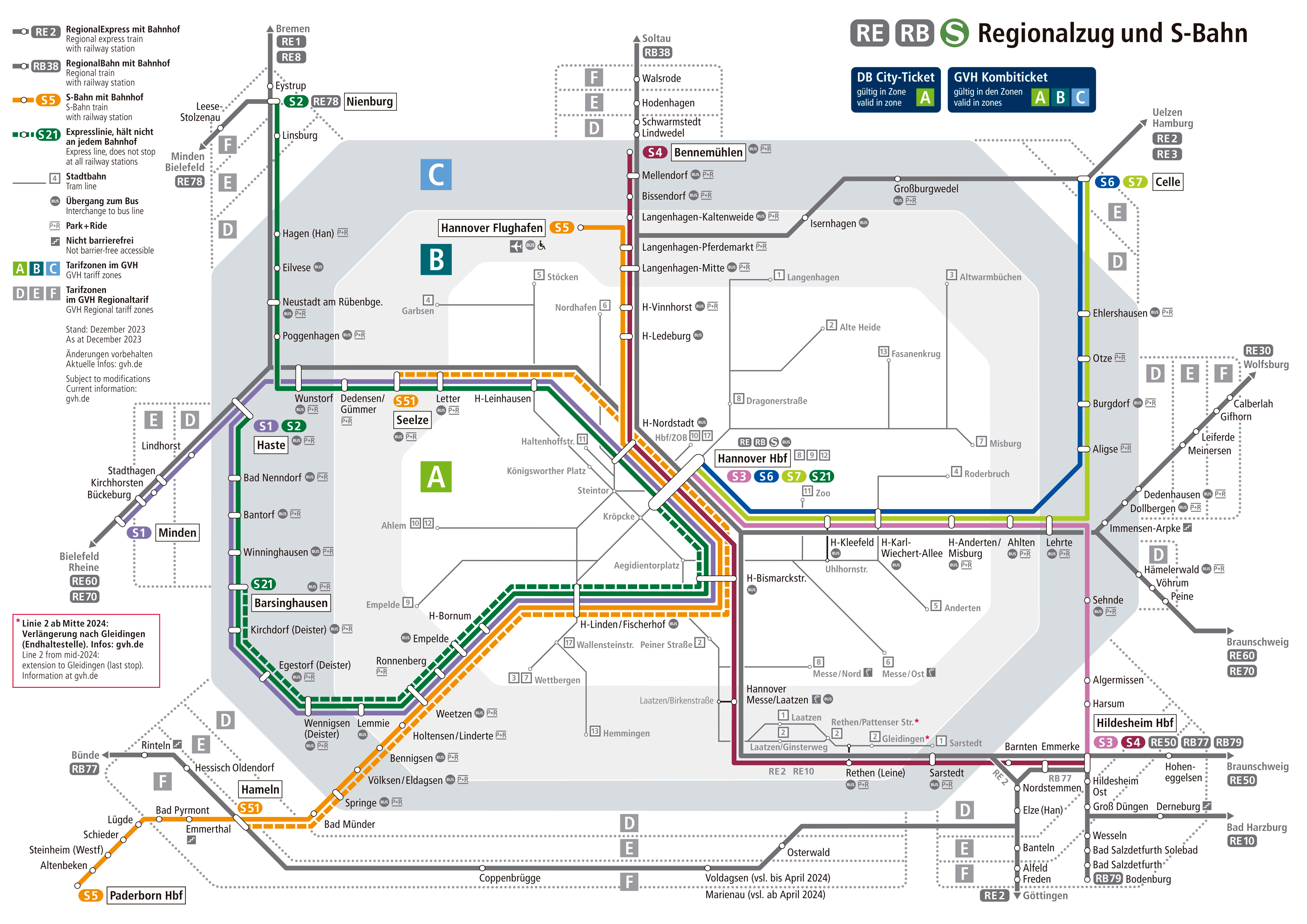
If you wish, have the previous map in PDF.
Bus map from Hanover:
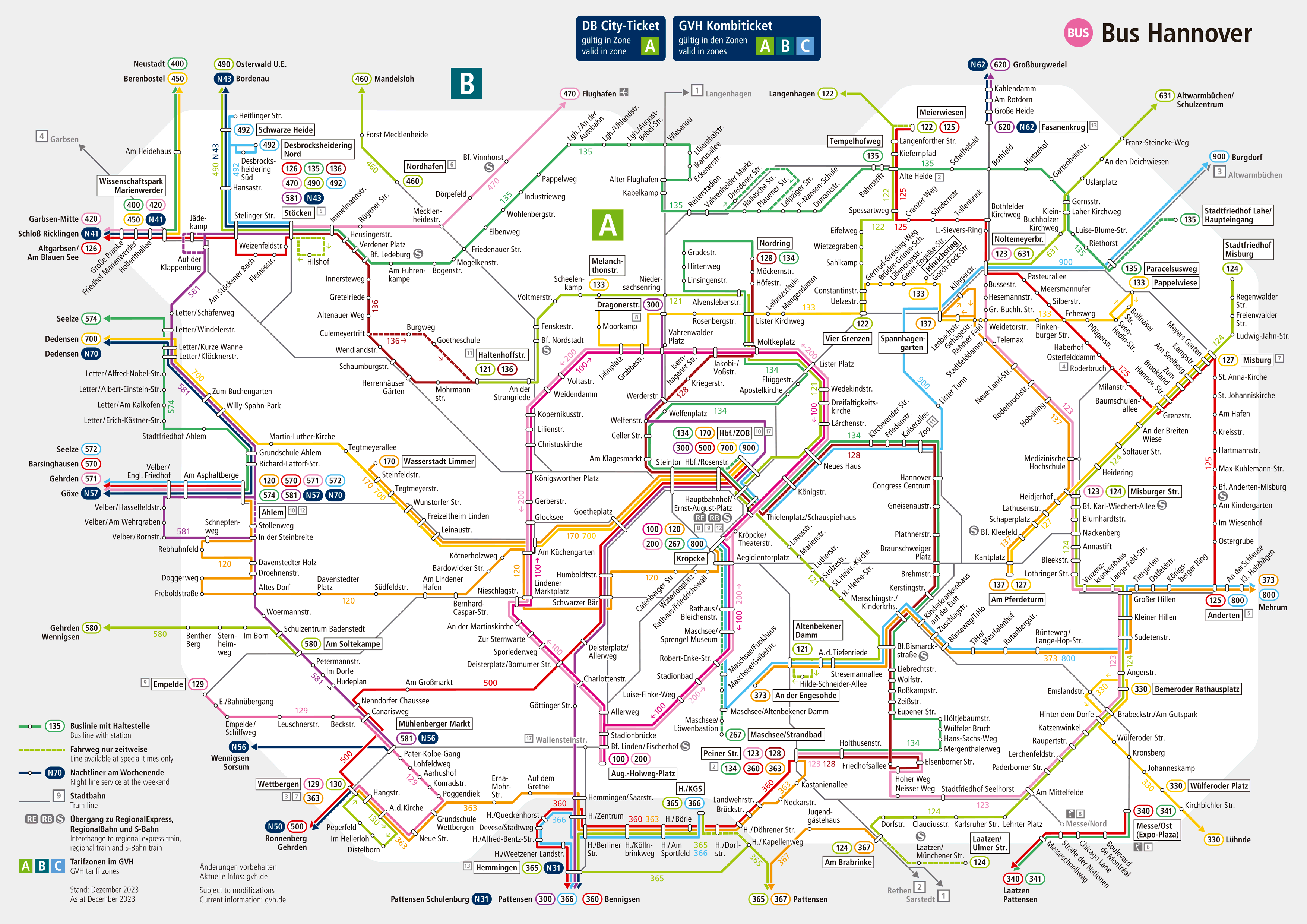
We also have the same bus map in PDF.
Schedules
- Weekdays and Saturdays: 4:30h a 1:30h
- Sundays and holidays: 5:00h a 0:30h
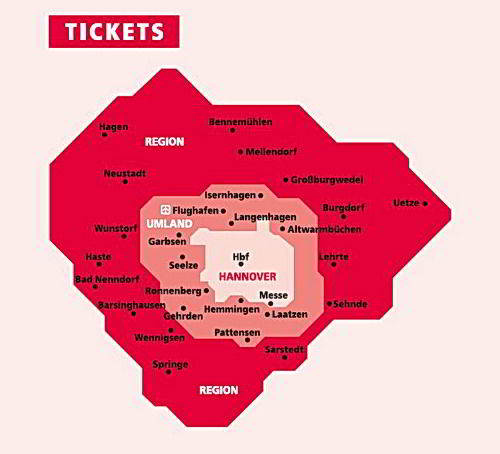
Rates
We present a table with the main prices in euros and their equivalent in US dollars.
| Type of ticket | Precio (EUR) | Precio (USD) |
|---|---|---|
| One-way ticket | 2,80 € | 3,07 $ |
| day ticket | 6,80 € | 7,45 $ |
| Children's day ticket | 2,60 € | 2,85 $ |
| Day ticket for groups (until 5 personas) | 12,50 € | 13,69 $ |
| Monthly ticket (Zone A) | 65,50 € | 71,78 $ |
| Monthly ticket (1th class, Zone A) | 125,70 € | 137,74 $ |
| Monthly ticket for seniors (from 60 years) | 33,20 € | 36,39 $ |
Besides, There are special options for tourists and discounts:
- HannoverCard: This card offers unlimited travel on public transport in Hanover, as well as discounts at museums, restaurants and other tourist places.
- Messefahrkarte: Special ticket for fair visitors, valid for unlimited rides during the days of the event.
- Jobtickets: Monthly subscriptions subsidized by companies, available for employees.
- Seniorennetzkarte: Monthly ticket with reduced fare for people over 60 years who receive a pension or are in early retirement.
Official Web site
- The official website of the urban tram: uestra.de
History of the Hanover city tram
The development of the tram system in Hanover began after World War II. In 1945, the city was devastated, and public transport infrastructure suffered serious damage. However, the reconstruction was quick, and to 1949 The idea of a “Unterpflasterbahn“, an underground tram line.
Planning and construction
In the decade of 1950, the first serious planning began to improve the tram system. In 1962, the transportation planner Bruno Wehner was commissioned to design an urban tram system. They are “Netzplan 64” proposed three main lines that intersected in the center of the city, at the station Kröpcke.
Construction began on 16 November 1965 in Waterlooplatz. Although initially there were financing problems, These were resolved with the support of the federal government in 1967..
Expansions and development
The first underground section, that connected Oberricklingen with the Hauptbahnhof, The 26 September 1975. This event marked the beginning of the operation of the Hanover urban tram system as we know it today..
In 1979 the line was inaugurated B-Nord, that connected Vahrenwald with the Hauptbahnhof, introducing high platforms in above-ground stations for the first time. This section was later extended to Garbsen in 1996.
Modernization and important events
During the decade of 1980 y 1990, Several major expansions were made, as the extension of the line B-Süd in 1982 and the line C-West in 1985. In preparation for the Expo 2000, Significant investment was made in the modernization and expansion of the urban tram infrastructure, including station renovation Kröpcke.
The inauguration of the line C-Nord in 1993 and later extensions, like line a Bemerode in 1999 already Misburg in 2014, reflect the continued growth of the system. The last major expansion was completed in 2023, extending the network to Hemmingen.
Technological innovations
Hanover's urban tram system has also been a pioneer in the implementation of new technologies. In 1996, Passenger information screens were introduced at main stations. In 1997, the new type train was presented TW 2000, designed by Jasper Morrison y Herbert Lindinger, and built by a consortium of LHB y Siemens.
These expansions and improvements have established the Hanover urban tram as an essential component of urban transportation in the city., offering an efficient and reliable service to its inhabitants and visitors.
The last station of the Stadtbahn of Hanover inaugurated is Hemmingen, he 29 January 2023.
History of the Hanover City Tram Map
The concept of the Hanover urban tram map originated in the 1970s. 1950, along with plans to build an underground transportation system. The initial idea was proposed by the transportation planner Bruno Wehner in 1962, who designed the “Netzplan 64“. This plan included three main lines that intersected at the station. Kröpcke. The first planned lines were lines A and B, which would later be carried out almost exactly as planned.
Creation and expansion
The construction of the urban tram began in 1965, and the first underground section was inaugurated in 1975. The original map was created to reflect these new underground lines and their connection to existing tram lines. As new lines and stations were inaugurated, the map was updated to include these expansions. The line B-Nord, For example, was added to the map in 1979 when the section was completed Vahrenwald.
Modernization and digitalization
In the decade of 1990, with the construction of new lines and underground stations, the map underwent a significant revision. The integration of the lines C-Ost y C-Nord in 1991 y 1993 respectively, required a complete map layout update to reflect these new routes. Besides, during preparation for the Expo 2000, Infrastructure improvements were made and key stations were renovated, which was also reflected on the map.
Contemporary design
The design of the Hanover urban tram map has been influenced by various designers and companies over the years. One of the most notable changes was made by the Italian designer Massimo Iosa Ghini in 1999, who modernized the station Kröpcke and contributed to the overall design of the map. Besides, The map has been adapted to be more accessible and easier to understand, integrating information on accessibility and connections with other modes of transport.
Additional data
The Hanover City Train not only connects residential and commercial areas, but also important tourist spots such as Hannover Messe (exhibition center), the stadium AWD-Arena and the Gardens of Herrenhausen.
Below you have the most important tourist sites in Hanover, and the nearest metro stop:
- Herrenhäuser Gärten (Herrenhäuser Markt, Line 4): Baroque gardens with impressive fountains and sculptures.
- Neues Rathaus (Aegidientorplatz, Line 6): Iconic town hall with panoramic views from its dome.
- Maschsee (Schlägerstraße, Line 1): Artificial lake perfect for water sports and relaxation.
- Altstadt (Kröpcke, Lines 3, 7, 9): Historic neighborhood with facades of half-timbered houses.
- Marktkirche (Markthalle/Landtag, Line 10): Gothic church from the 14th century in the heart of the city.
- SEA LIFE Hannover (Herrenhäuser Gärten, Line 4): Aquarius with more than 2,500 Marine creatures.
- Schloss Marienburg (Hauptbahnhof, Line 1, then regional train): 19th century neo-gothic castle, home of the Welf.
- Berggarten (Herrenhäuser Gärten, Line 4): Botanical garden with collections of plants from all over the world.
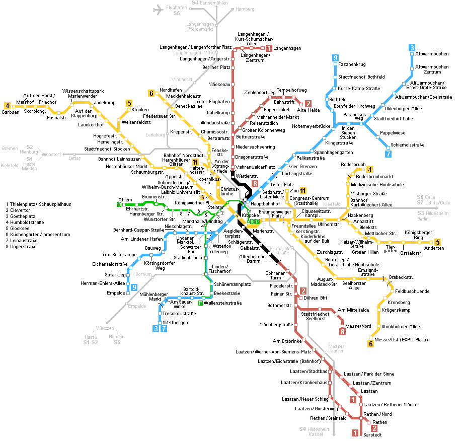
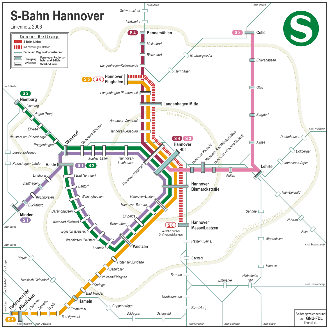
Old maps of the Hanover city tram
In a historical way we will hang the old transport maps of Hanover. The following maps are from the year 2014: