The Barcelona metro is officially known as “Metro de Barcelona”, and it is one of the most important and extensive underground transport networks in Europe, located in Barcelona, Spain.
Inaugurated on 30 December 1924, This metro system has constantly evolved, experiencing its last expansion in the year 2021. It has a total of 12 lines that cover 189 stations, covering a length of 170 kilometres (about 105,63 miles).
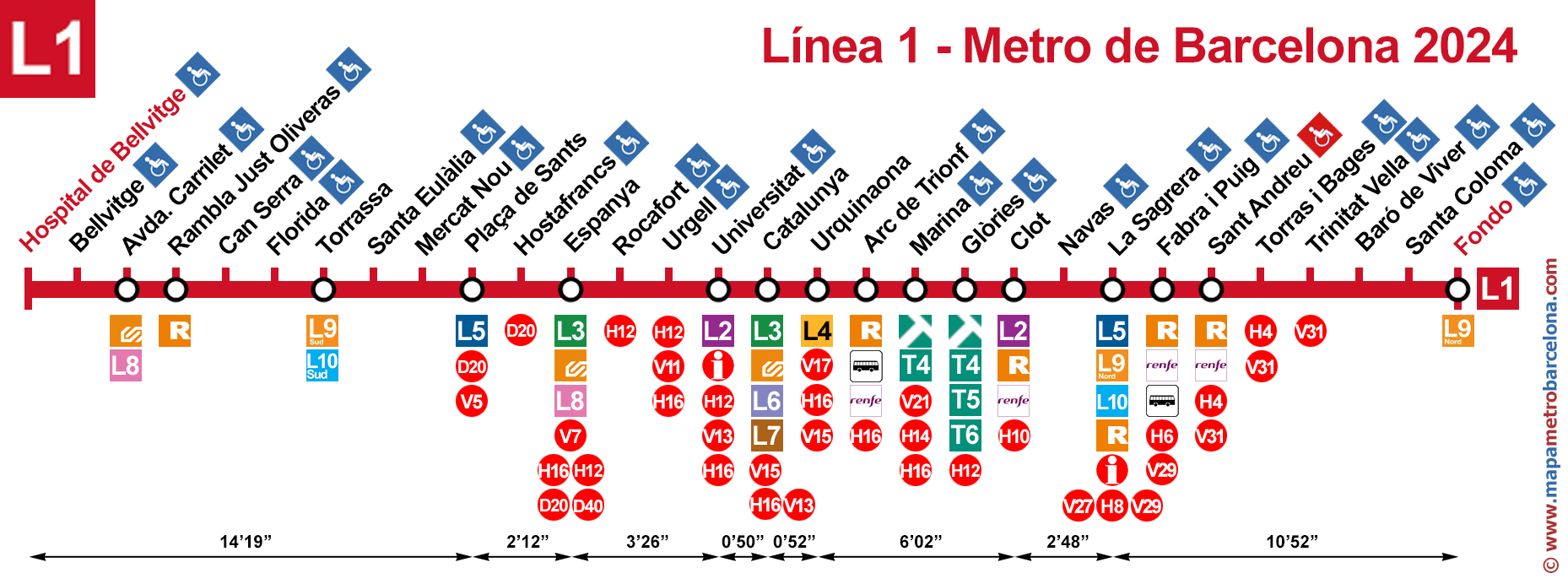
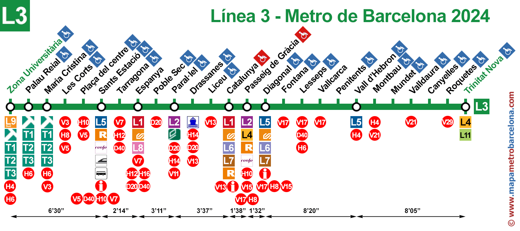
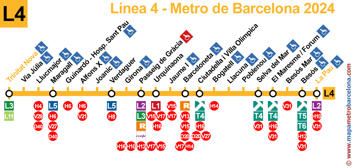
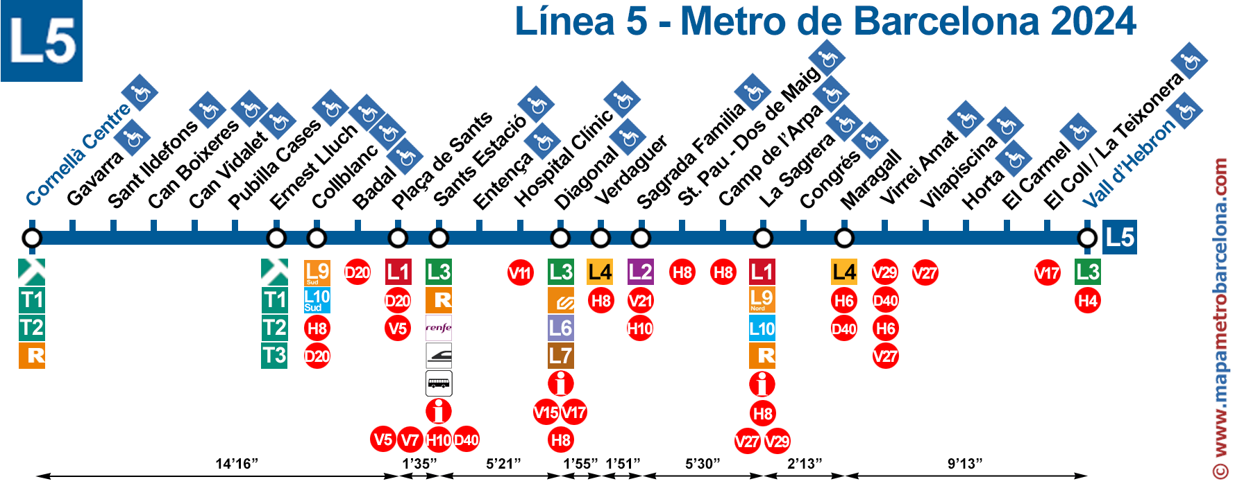
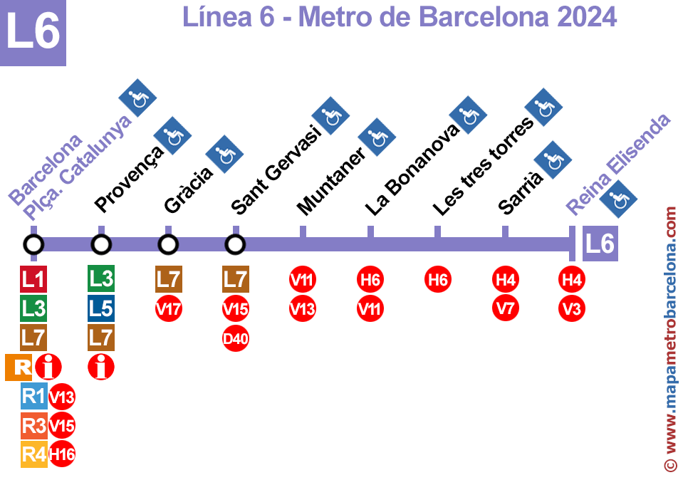
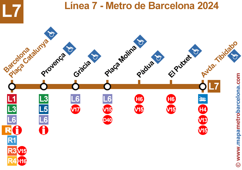
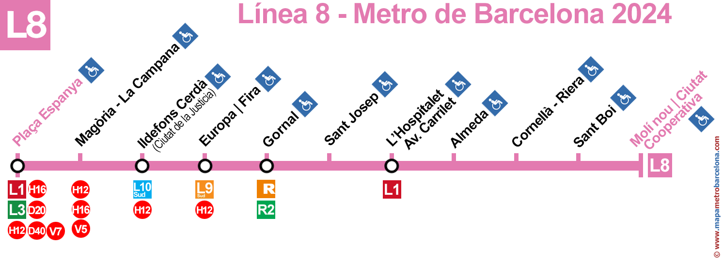
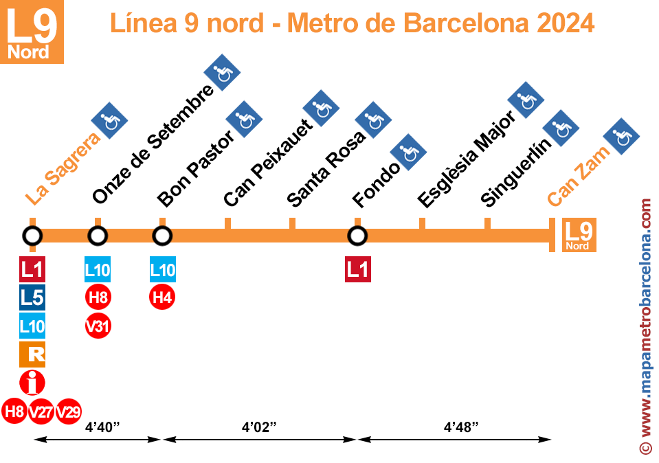
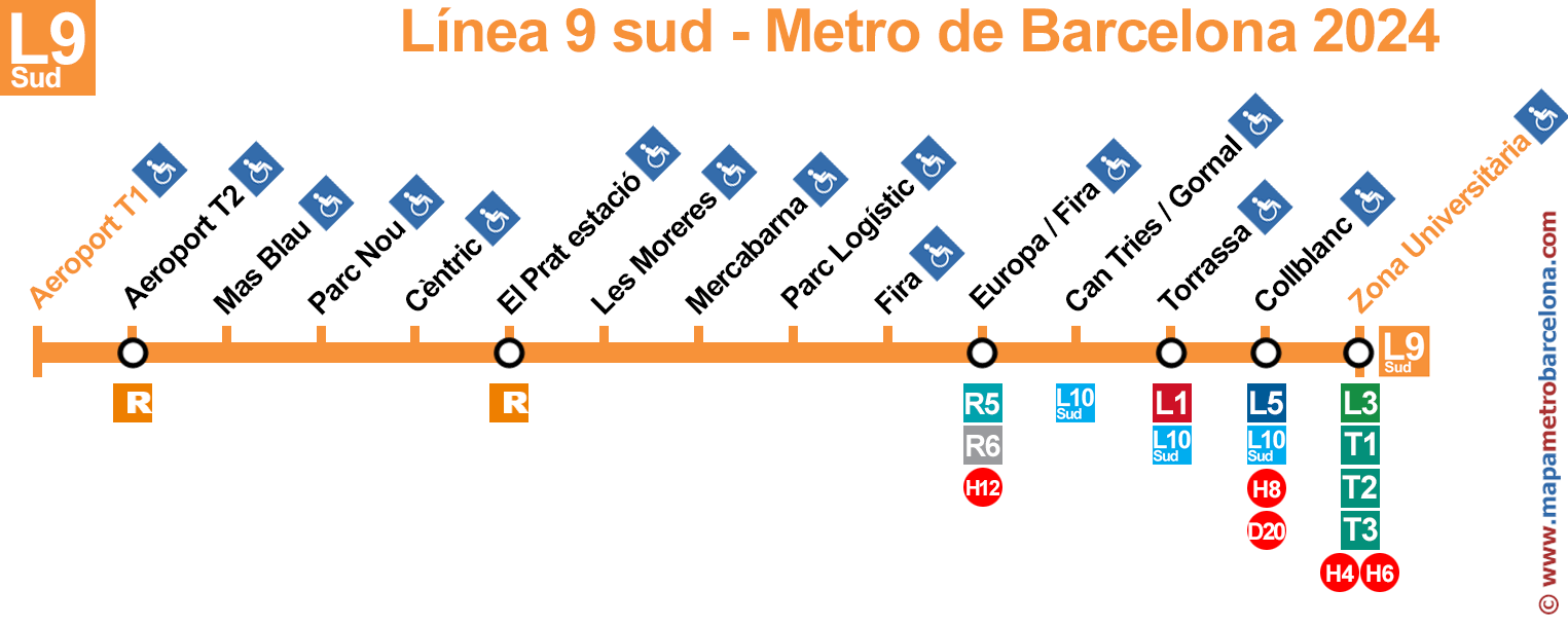
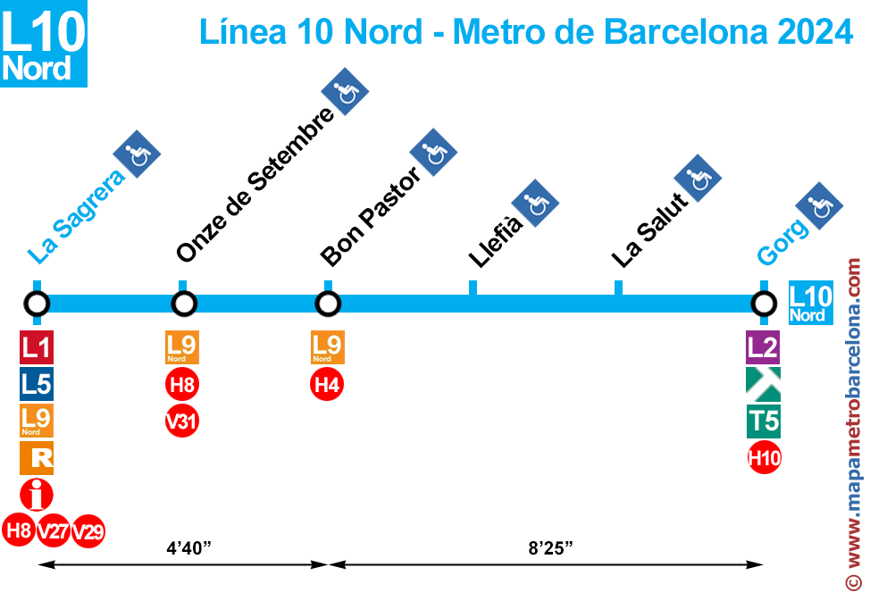
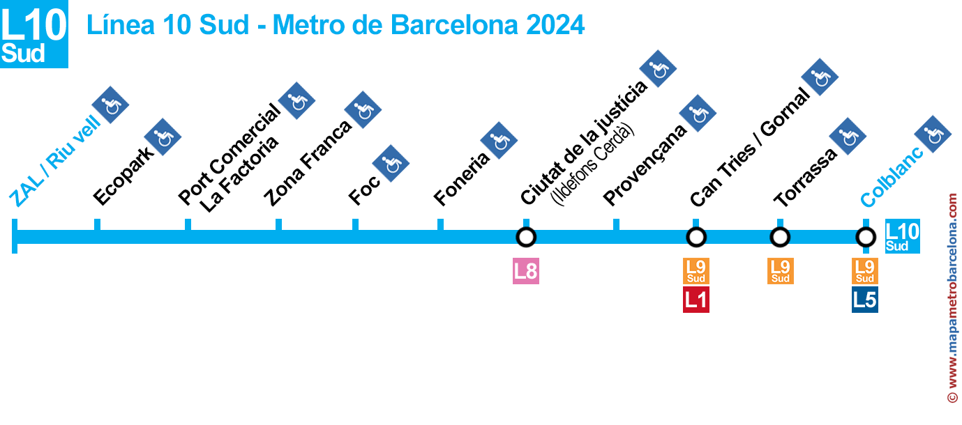
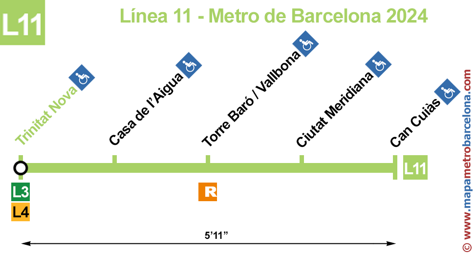
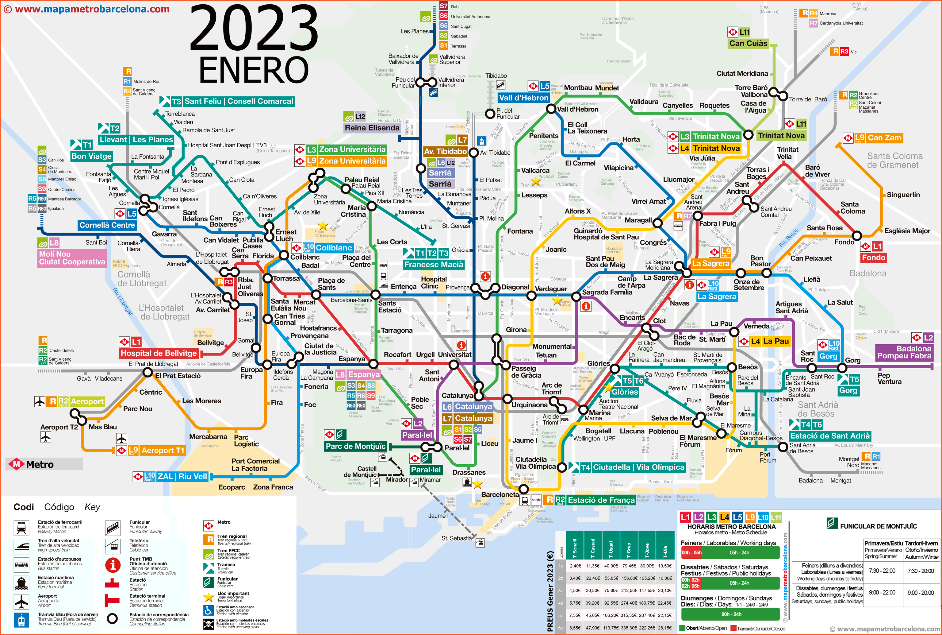
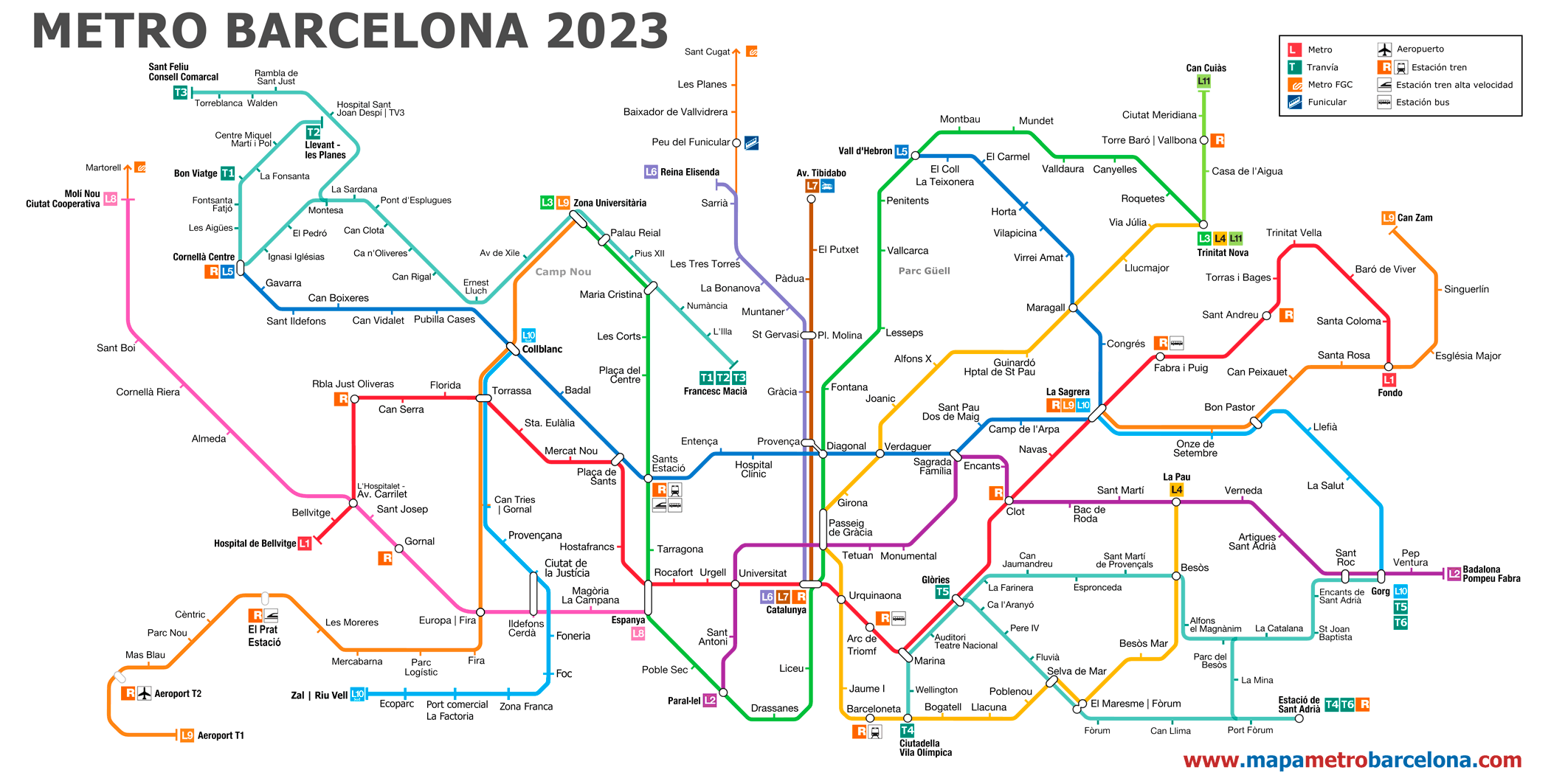
subway map
Here's the Barcelona metro map with the lines, and transfers to other metro lines and other types of transport. Click on an image to see it larger:
RECOMMENDATION: On this website you can see all the interesting things in Barcelona, as museum attractions, monuments, and other interesting things about the city of Barcelona, museums, attractions, events, parties, and curious things that will surprise you.
Official websites
- Unofficial website of the Barcelona metro (This website is very easy to use and is where we got the maps from, since they update them frequently).
- Official website of the Barcelona metro.
- Tiqets official website, They have a lot of tourist attractions and very interesting places to visit. And by the way, They sell some museum tickets cheaper, attractions, touristic bus, etc.
Barcelona metro schedules
The metro operates with the following schedules:
- Monday to thursday: of 5:00h a 00:00h. (5:00 a.m. until 12:00 a.m.).
- Friday: of 5:00h a 2:00h of the next day. (5:00 a.m. until 2:00 a.m.)
- Saturdays: continuous service 24 hours.
- Sundays and holidays: until 24:00h.
Rates
Ticket prices offer different options to adapt to the needs of travelers:
- One-way ticket: 2.40 EUR (~2.63 USD), valid for a single trip within the network.
- T-casual: 11.35 EUR (~12.45 USD) for 10 trips.
- T-usual: unlimited monthly subscription 40 EUR (~43.90 USD).
- T-jove: unlimited quarterly pass for young people under 25 years for 80 EUR (~87.90 USD).
- T-dia: daily ticket with unlimited travel during 24 hours per 10.50 EUR (~11.50 USD).
All rates depend on the areas to be visited, being those mentioned for an area.
History of the Barcelona metro
Barcelona metro, inaugurated in 1924, emerged as a modest project with a first line that united Lesseps y Catalunya, marking the beginning of a crucial transportation system for the city. Since then, the network has evolved significantly, expanding to meet the increasing demands of an ever-growing city.
In 1926 a second line was added, known as Great Metropolitan, connecting Plaza Cataluña with the Sants neighborhood, laying the foundations of an infrastructure that would expand in the following decades. During the postwar, despite economic difficulties, The system grew with the construction of new lines and stations that strengthened its coverage in the city..
Total electrification of the roads, the automation of signals and the introduction of more modern and comfortable trains, especially since the decade of 1970, reflected the system's commitment to efficiency and modernity. Preparations for the Olympic Games 1992 marked a turning point, because they accelerated the expansion and modernization works, including the construction of the line 2 and improvements to existing lines.
In the years 2000, the system adopted contactless ticketing technology, providing a smoother user experience. Automation also reached a new level with the opening of the Line 9/10, a long line with fully automatic trains.
Nowadays, the Barcelona metro covers 12 lines that cross and connect the city with metropolitan areas.
History of the Barcelona metro map
decade of 1920 – The first strokes: The first map of 1924, under the supervision of the engineer Santiago Rubió i Tudurí, represented the initial network that connected Lesseps, Diagonal, Aragó (actual Passeig de Gràcia) y Catalunya. It was a simple design, suitable for a small network. As new lines were added in the following years, Map complexity increased to reflect network growth.
Years 1950-1980 – Expansion and normalization: With the progressive expansion, the map began to show multiple lines with distinctive colors, facilitating orientation.
Years 1990 – Olympic modernization: During the preparations for the Olympic Games 1992, The map has been redesigned to improve visual clarity, simplifying connections and making lines more visible.
Contributions from Mario Corea Aiello: During the last decades of the 20th century, Mario Corea Aiello significantly influenced the design, creating a clear and modern structure.
XXI century – Simplification and technology: In the years 2000, with the opening of new lines, especially the automatic ones 9 y 10, the map became more “diagram style”, using simplified schemes and distinctive colors for each line, ensuring faster guidance.
Redesign of Josep Maria Trias: In recent years, Josep Maria Trias made a redesign that established the basis of the current map, improving the identification of lines and their connections.
Review by Jug Cerovic y Martí Ruiz: In April 2024, Jug Cerovic y Martí Ruiz they modernized the map, maintaining the Trias structure, but simplifying it to improve readability and adapting it to modern digital demands.
Additional data
Turismo:
For visitors who want to explore the city's cultural wealth, the subway is the ideal option. Most tourist attractions are directly accessible, from various stations on the metro network:
- Sagrada Família (Sagrada Família, L2, L5): Gaudi's masterpiece, under construction since 1882, symbolizes the essence of Catalan modernism.
- Guell park (Lesseps, L3): A magical park designed by Gaudí, Known for its colorful mosaics and panoramic views of the city.
- Gothic Quarter (James I, L4): The historic heart of Barcelona, full of narrow streets and medieval architecture, ideal to get lost in time.
- Casa Batlló (Passeig de Gràcia, L2, L3, L4): A jewel of Catalan modernism with an undulating façade that reflects Gaudí's creativity.
- Las Ramblas (High school, L3): The most famous avenue, full of life, street artists and markets, as La Boquería, that represent the soul of the city.
- Montjuïc (Spain, L1, L3): A mountain with numerous attractions, including the National Palace, the Magic Fountain and spectacular views.
- Museo Picasso (James I, L4): Contains more than 4,000 works of the genius from Malaga, showing his artistic evolution and his connection with Barcelona.
- La Pedrera (Diagonal, L3, L5): Another incredible building by Gaudi, also known as Casa Milà, famous for its innovative design and spectacular rooftop.
Other maps line at the Barcelona metro: