The Beijing Metro (北京地铁) It is the backbone of public transportation in China's capital. Inaugurated on 1 October 1969, It is the oldest subway system in China.
At the moment, has 24 lines and 392 stations, spreading throughout 727,9 kilometres (452,3 miles).
This system, that serves more than 10 million daily passengers, has experienced rapid expansion since 2002, especially driven by the 2008 Olympic Games.
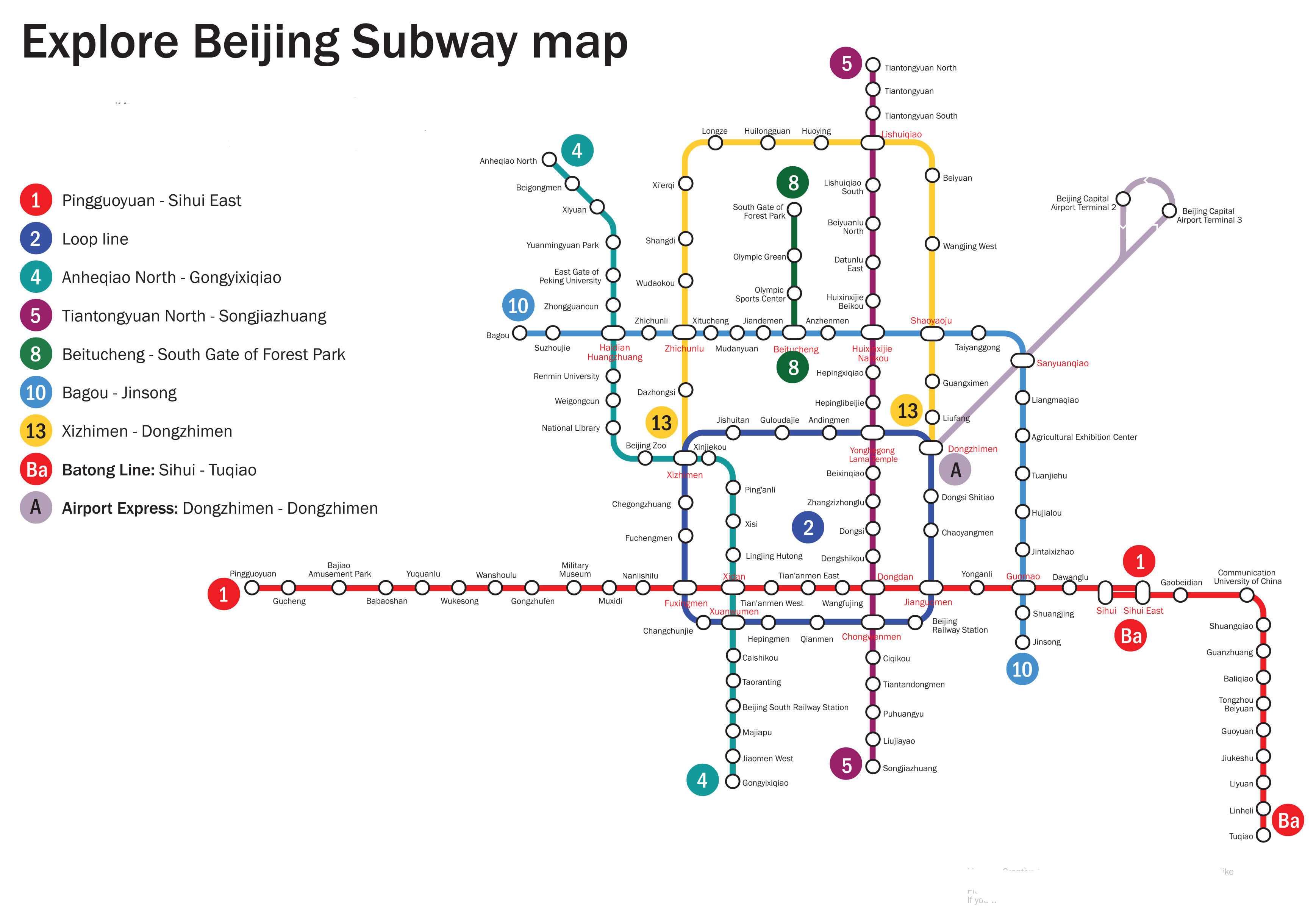
subway map
Below is the map of the Beijing subway. Click on any map to see them larger:
The same Beijing metro map in PDF format.
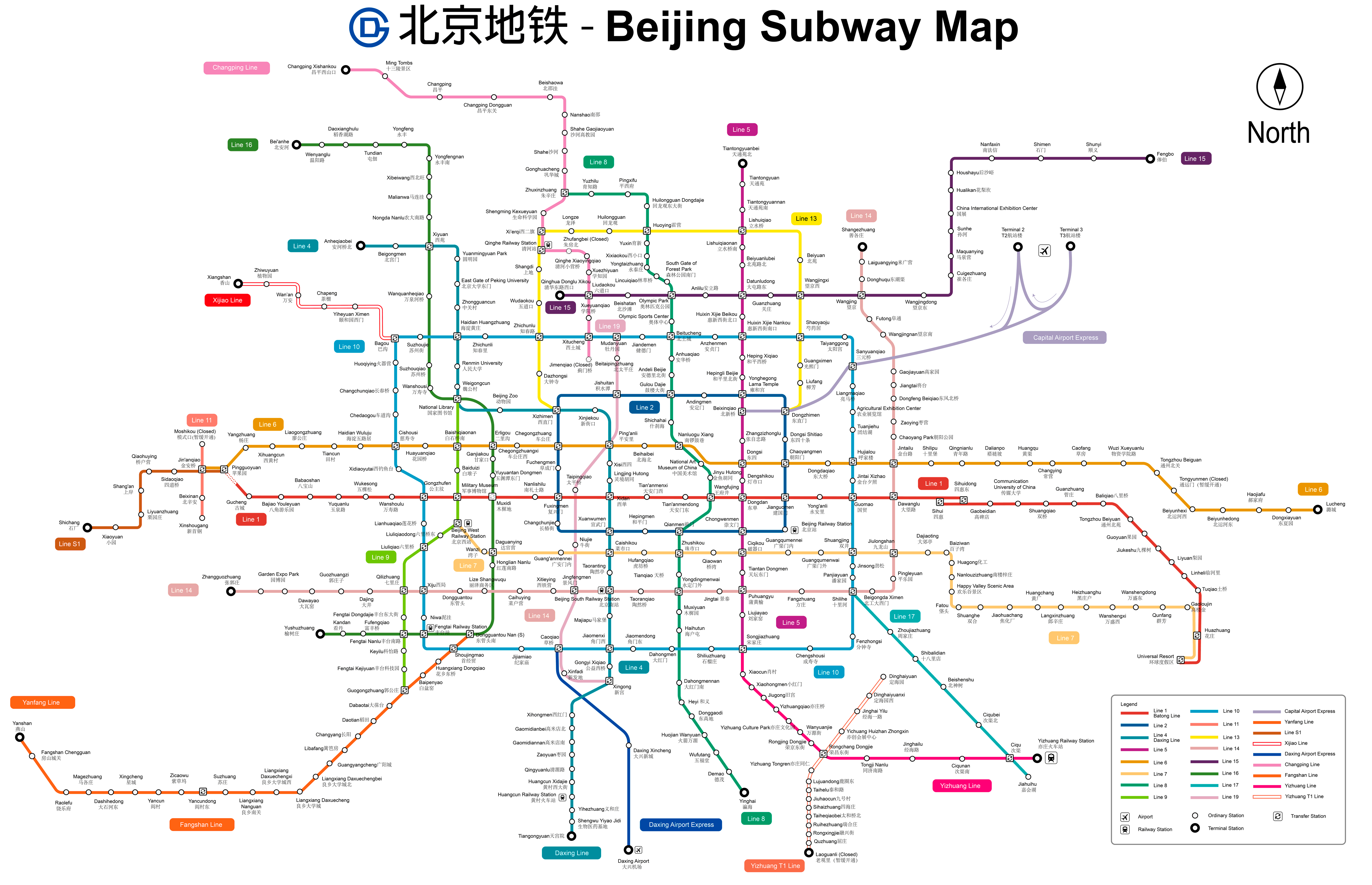
The following is the Beijing subway and railway map:
We also have a version of Beiging railway map in PDF format.
Schedules
- Working days and holidays: 5:30h a 23:00h.
Rates
The Beijing subway fare system is based on distance traveled. Next, A table is presented with the main prices in Chinese yuan (CNY) and its equivalent in US dollars (USD), so that tourists can get a better idea of the price:
| Distance traveled | Precio (CNY) | Precio (USD) |
|---|---|---|
| 0-6 km | 3 | 0.43 |
| 6-12 km | 4 | 0.57 |
| 12-22 km | 5 | 0.72 |
| 22-32 km | 6 | 0.86 |
| >32 km | +1 each 20 km | +0.14 each 20 km |
- Card Yikatong (一卡通): This reloadable card offers discounts on frequent travel and is valid for all public transportation in Beijing. Users can benefit from a discount of 20% after doing more than 100 trips in a month.
- Tourist Card: Tourists can purchase a special card that includes unlimited travel for one or several days. These cards are ideal for those who plan to use the subway extensively during their stay in Beijing.
- Discounts for students and seniors: Students with valid identification and people over 60 years can enjoy reduced rates. Specific discounts vary and often require a special identification card issued by local authorities.
- Free trips for children: Children under 1.3 meters tall can travel for free when accompanied by an adult with a paid ticket.
Yikatong card usage example
For those who use Yikatong card, the recharging process is simple. Recharges can be done at metro stations, convenience stores and through mobile applications. The card also allows payments in taxis and some commercial establishments.
Official Web site
- The official website of Beijing subway: www.bjsubway.com
History of the subway
The Beijing subway began its history in 1965, approved for military purposes. The construction of the first line of 24 km (14,9 miles) started on 1965 and was completed 1 October 1969. This line connected the Beijing railway station with Gucheng and was designed for military and government use..
During the Cultural Revolution, The line suffered several technical problems. In 1970, An electrical fire caused the death of three people and injured multiple people, which led Premier Zhou Enlai to transfer the management of the subway to the People's Liberation Army.
The first significant expansion occurred in the years 80. In 1981, a line was opened tracing the ancient walls of the Ming city. This became the current lines 1 y 2, connecting key points such as Tiananmen and the Forbidden City. These two lines formed the core of the system until the beginning of the 21st century..
Preparation for the Olympic Games 2008 drove massive expansion. In between 2002 y 2008, the lines were built 4, 5, 10 y 13, in addition to the special line for the airport. The line 4, managed in part by MTR Corporation, It was inaugurated in 2009.
In 2007, the line was opened 5, the first on a north-south axis, con 27,6 km long (17,1 miles). One year later, in 2008, the lines were inaugurated 8 y 10 (the latter with an additional extension in 2013, forming an outer ring). Total, were built 148,5 km (92,3 miles) of new lines for the Olympic Games.
From 2010, the subway continued to expand rapidly. In 2010 Changping lines were inaugurated, Daxing, Yizhuang y Fangshan. The line 15 also opened in 2010, expanding into 2017. In between 2012 y 2015, additional phases of the lines were completed 8, 9 y 14.
The current system, is managed by Beijing Mass Transit Railway Operation Corporation y Beijing MTR Corporation. It has reached a total length of 727,9 km (452,4 miles), and continues to grow.
Beijing subway map history
The Beijing subway map has evolved significantly since its initial creation. On the first years, the map design was rudimentary, reflecting the few operational lines. As the system grew, so did the complexity and accuracy of the map.
In the years 80, when the subway began to expand with the lines 1 y 2, The design of the map was entrusted to teams of local engineers and graphic designers.. Responsibility for the design fell to government and academic institutions that worked collaboratively to create a clear and functional representation of the system..
With the subway construction boom in the 1990s 2000, motivated by preparations for the Olympic Games 2008, the subway map needed a considerable update. Companies like the Beijing Mass Transit Corporation and international firms such as MTR Corporation participated in the modernization of the design. This phase included the integration of new lines and updating the graphic design to make it more accessible to local and foreign users..
The implementation of advanced technology also played a crucial role in the evolution of the map. Geographic information systems were introduced (SAY) and computer-aided design software (CAD) to improve map accuracy and usability. Besides, Collaboration with usability and interface design experts helped optimize the visual presentation of the map for more intuitive navigation.
In the last decade, designers like Qieer Wang have contributed to the modern stylization of the subway map, incorporating graphic elements that are not only functional but also aesthetically pleasing.
Additional data
The Beijing subway is not only an engineering marvel, but also a cultural reflection. The Beijing Metro Cultural Park, inaugurated in 2010, celebrates the history of the system with exhibits and antique train cars.
These are the most important tourist places in Beijing and how to get there by subway:
- Tiananmen Square (Tiananmen West, Line 1): The largest square in the world, symbol of China, ideal to see the raising of the flag.
- Forbidden City (Tiananmen East, Line 1): former imperial palace, the largest palace complex in the world.
- Great Wall in Badaling (Badaling, Line S2): Best preserved section of the Great Wall, accessible and very popular.
- Heaven Temple (Tiantandongmen, Line 5): Place where emperors prayed for good harvests, famous for its architecture.
- summer Palace (Beigongmen, Line 4): Imperial garden with stunning landscapes and historic architecture.
- Hutongs de Beijing (Nanluoguxiang, Line 6 y 8): Traditional alleys showing the ancient life of Beijing.
- Old Temple (Yonghegong, Line 2 y 5): Tibetan Buddhist monastery famous for its statue of Maitreya Buddha.
- Parque Beihai (Beihai North, Line 6): Imperial park with a large lake and the famous white pagoda.
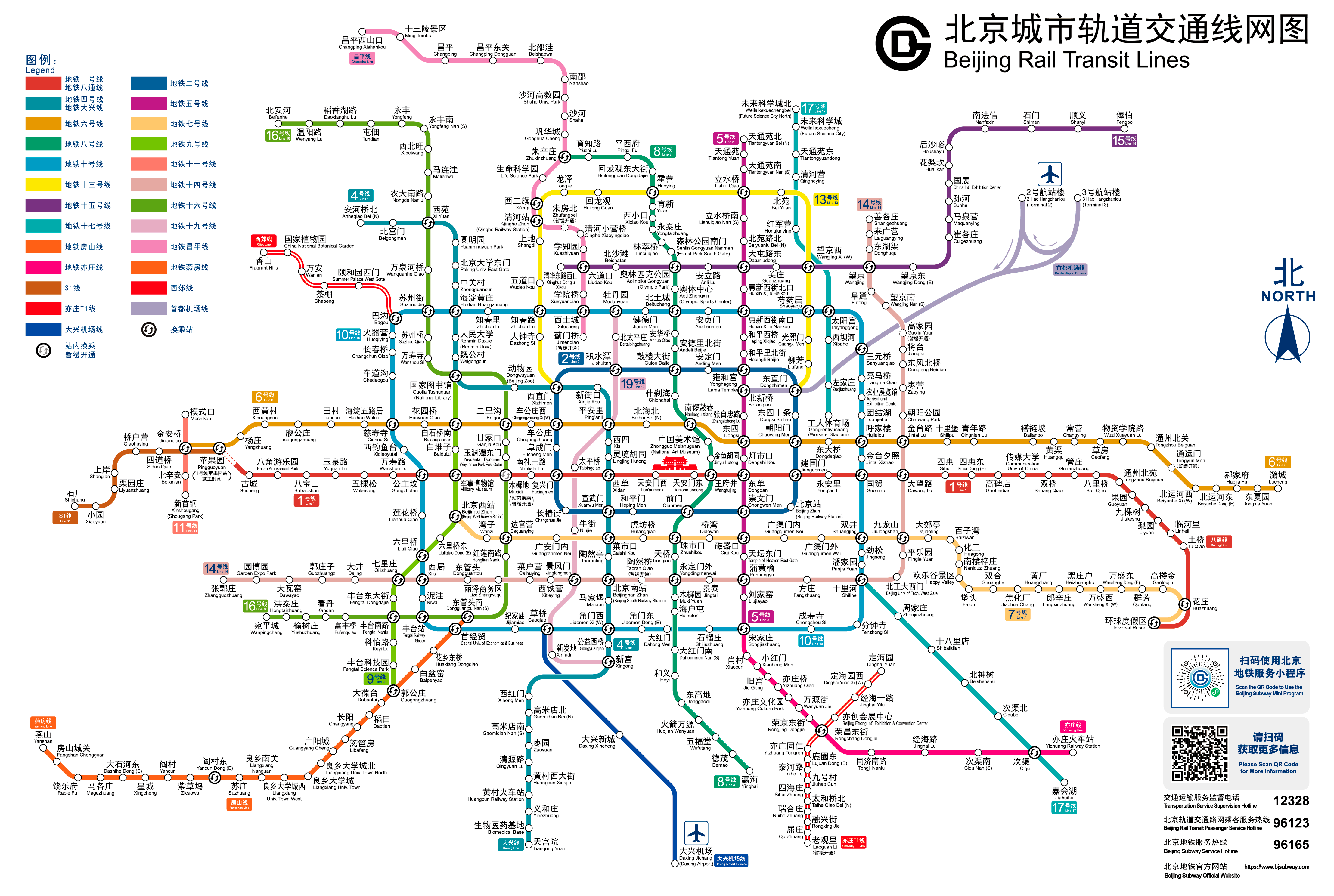
Old plans
And then, old subway plans, in this case of 2014, We will put them here as the years go by..
old map 2: