The Medellín metro is the underground and elevated transportation system that operates in the city of Medellín, Colombia. Inaugurated on 30 November 1995, It was the first metro system in Colombia and has gone through several expansions, with the last one made in 1996.
At the moment, has 2 lines that cover 26 stations along 32 kilometres (about 19.88 miles).
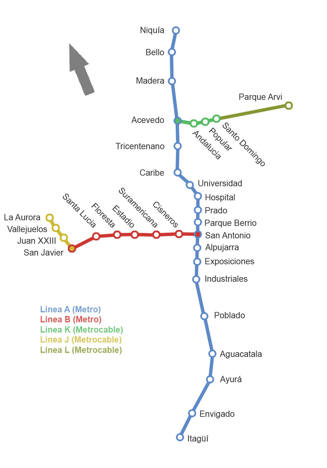
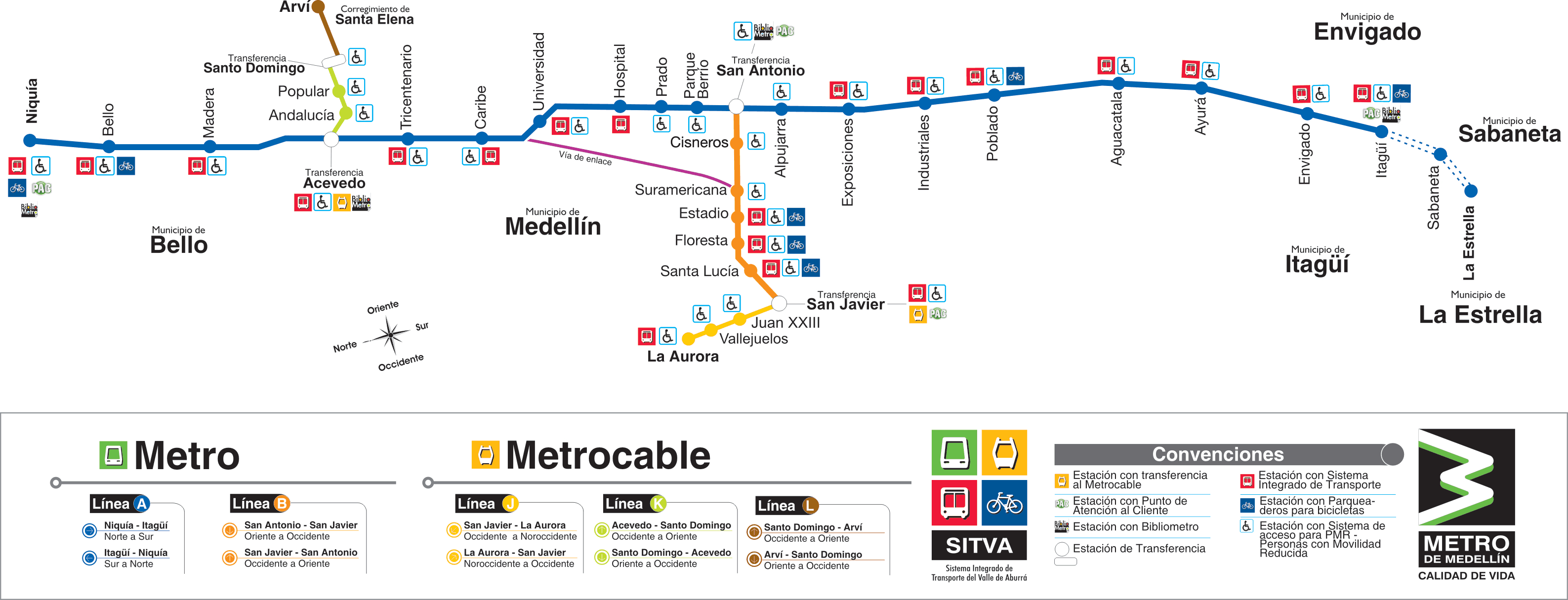
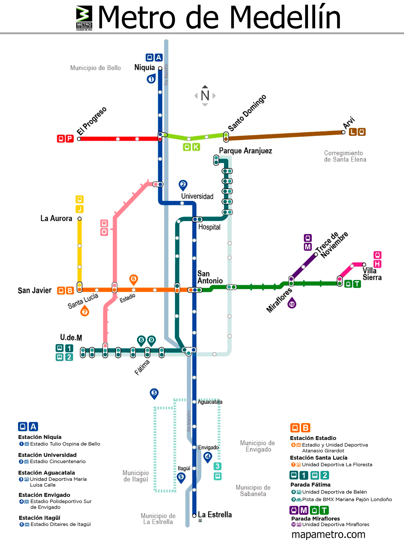
subway map
Here's the Medellín metro map:
We also have the version of Medellín metro map in PDF.
Official Web site
- For more information, visit the official site of the Medellín metro.
- On this other website you can see the complete list of tourist attractions in Medellín and other places to go, which may surprise you.
Schedules
The Medellín metro operates with the following schedules:
- Work days: of 4:30 a.m. until 11:00 p.m.
- Saturdays: of 4:30 a.m. until 11:00 p.m.
- Sundays and holidays: of 5:00 a.m. until 10:00 p.m.
Medellin metro rates
Below are the prices for tickets and travel cards. We have written the approximate price in dollars, so that tourists get a better idea of the price:
| Ticket/Card Type | Description | COP tariff | USD rate |
|---|---|---|---|
| One-way ticket | Allows only one trip on any line in the system | 2,550 | ~0.57 |
| Civic Card | Rechargeable smart card offering reduced rates | – | – |
| Travel by subway and tram | Cost with Civic Card | 2,430 | ~0.54 |
| Travel in Metrocable | Cost with Civic Card | 2,430 | ~0.54 |
| Special rates | Rates for specific groups (students, older adults, People with disabilities) with the Civic Card | – | – |
| Integration with SITVA | Convenient transfers and integrated fares between metro, buses and EnCicla system with the Civic Card | – | – |
- Civic Card: It is a rechargeable smart card that allows access to cheaper rates. Users can load the card with balance and enjoy reduced rates:
- Special rates: The system also has special rates for specific groups of passengers.:
- Students: Students who meet certain criteria can get reduced rates.
- Older adults: Seniors who carry the Civic Card enjoy discounts.
- People with disabilities: Reduced fares for passengers with disabilities who have the special card.
- Integration with SITVA: The Medellín metro is integrated with other public transportation systems such as buses and the EnCicla. When using the Civic Card, Passengers can transfer between different modes of transportation conveniently, enjoying integrated rates for more efficient mobility.
About the metro and its connections
Medellín's metro system includes a variety of lines, not only the two main lines which are Line A and Line B. Here we detail the lines that currently make up the system:
- Line A (metro): Niquia to La Estrella.
- Line B (metro): San Antonio a San Javier.
- K line (Metrocable): Acevedo a Santo Domingo Savio.
- J Line (Metrocable): San Javier a La Aurora.
- L line (Metrocable): Santo Domingo Savio a Arví.
- H line (Metrocable): Oriente a Villa Sierra.
- M Line (Metrocable): Miraflores a Trece de Noviembre.
- P line (Metrocable): Acevedo a El Progreso.
- T-A Line (tram Ayacucho): San Antonio a Oriente.
Total, The system includes two traditional metro lines, four lines of Metrocable and a tram line, offering an integrated network that facilitates mobility through different areas of the city, including hard-to-reach areas in the hills.
History of the subway
The Medellín Metro project began in the 1970s. 1970. In 1979, The Mass Transportation Company was created Valle de Aburrá Ltda., responsible for developing the system.
The works began in 1985 and were led by the Spanish-German consortium Metromed, who received a contract “turnkey” to plan, design, supply, execute civil works, to assemble, train staff and launch the metro.
The 30 November 1995, the first line was inaugurated, Line A, that covered the stretch between Niquía y Poblado. This line, of 23.2 kilometres, counted on 21 stations and marked a milestone in the mobility of Medellín.
The second phase included Line B, inaugurated on 28 February 1996, who added 5.5 kilometers to the system, connecting the center with the west of the city from San Antonio until San Javier.
XXI century
In 2004, Line K opened, a metrocable that one Santo Domingo Savio with the rest of the system, standing out for its innovation in public transportation in mountainous areas.
In 2008, Line J was added, another metrocable, that goes from San Javier to Aurora. This project also included an important social component, improving the quality of life of marginalized communities in Medellín. Posteriorly, in 2016, Line H was inaugurated, a third metrocable that connects Oriente y Villa Sierra with main system.
The Tram Ayacucho, part of the line T-A, started operating in 2015, revitalizing the central east of Medellín and serving as a sustainable and modern transportation model.
Regarding the companies involved, Metromed was not only in charge of the construction, but also the supply of materials, highlighting the contribution of national engineering and industry in various aspects of the project.
In the future and in theory before the year 2030, The Medellín metro will be expanded by adding new stations between Industriales y Poblado, and between Envigado e Itagüí. Future projects for Metrocable, are that line M and the new lines planned in Itagüí. And as for the tram, a new tram line will be added on Avenida 80 from Aguacatala until Caribe. And the future tram lines are planned to Río Negro and the international airport José María Córdova, and in Sabaneta.
History of the Medellín metro map
Till the date, no detailed information about the specific designers of the Medellín metro maps throughout its history has been publicly documented..
Although graphic maps do exist and are an essential tool for navigation within the metro system, details about its creators or specific modifications over the years, They are a complete mystery at the moment.
Additional data
The Medellín metro allows passengers to access some points of tourist interest such as:
- Parque Explora: An interactive park with science, technology and innovation.
- Medellin Botanical Garden: A green lung full of biodiversity.
- Park of the Pies Descalzos: A place to relax in the middle of the city.
Old maps of the Medellín metro
In historical mode, we will be posting the subway maps, in this case they are from the year 2014 and previous: