Melbourne Metro, officially known as “Metro Trains Melbourne”, is a suburban train system that operates in the city of Melbourne, Australia. Although it is not an underground subway in the traditional sense, It is a vital component of the city's public transportation system.
The system covers a large network with 16 lines and more of 200 stations, over approximately 998 kilometres (620 miles) of roads.
The network is managed by metro Trains Melbourne, An alliance between MTR Corporation, John Holland Group y UGL Rail.
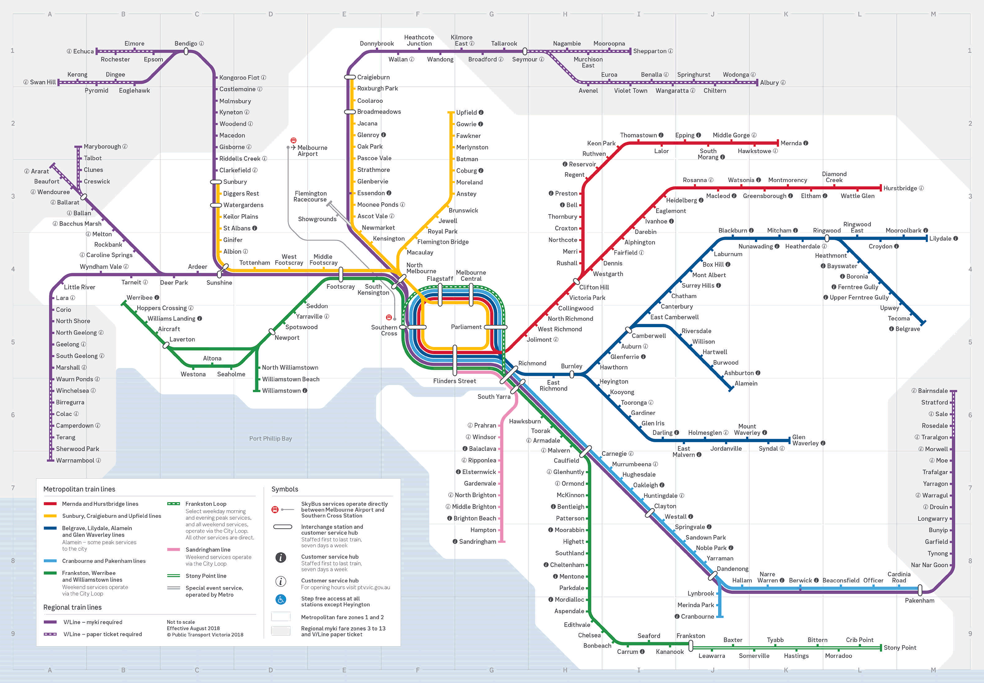
Here's the melbourne metro map. Click on the image to enlarge it:
Melbourne Metro timetable
- Work days: 4:00h to midnight
- Saturdays: 4:00h to midnight
- Sundays: 5:00h to midnight
Rates
- Price of a ticket in local currency: 4.50 AUD (2.90 USD).
Official Web site
- This is the official website: metro Trains Melbourne.
- This is the website with See all Melbourne attractions.
History of the Melbourne Metro
XIX century
The history of the Melbourne suburban rail system, known as “Metro Trains Melbourne”, dates back to the mid-19th century. Inaugurated in 1854, the system is one of the oldest in Australia. Originally built and operated by different private companies, the system passed into government hands in the 20th century, which allowed greater integration and expansion of the network.
Twentieth century
In the decade of 1970, construction of the first significant underground tunnel began, known as the “City Loop”, which was gradually inaugurated between 1981 y 1985. This project aimed to alleviate congestion at the Flinders Street and better distribute passengers through new centrally located stations: Parliament, Melbourne Central y Flagstaff.
XXI century
In 2008, Sir Rod Eddington proposed ambitious plan to improve Melbourne's east-west connectivity, including a new railway tunnel and Flagstaffwhich would connect the Sunbury and Pakenham-Cranbourne lines through the city centre. It's plan, known as the Melbourne Metro Rail Project, It was officially adopted by the state government and has undergone several revisions and expansions since then..
The project Melbourne Metro Tunnel, started in 2018, It is one of the most important expansions of the system. This project of 12.58 billion AUD (about 8.76 billion USD) includes the construction of a tunnel 9 kilometers that will connect the Sunbury and Dandenong lines, with five new underground stations: Arden, Parkville, Anzac, Town Hall y State Library. The project also plans to connect the system with the future rail link to Melbourne Airport.
The tunnel, which is built at a depth of up to 40 meters, is the largest railway project in Victoria since the construction of the City Loop. Tunnel operation is expected to begin in 2025, and is anticipated to significantly improve system capacity and efficiency, allowing a greater number of trains and facilitating access to key areas of the city.
The development of this project has involved several companies and has generated thousands of jobs in the region. Companies such as Alstom and Evolution Rail have been crucial in the manufacture and maintenance of rolling stock, while the project has trained numerous apprentices and engineers, consolidating its importance both in economic and infrastructure terms.
Melbourne Subway Map History
The Melbourne metro map has evolved significantly since the rail system's inauguration in 1854. The first maps were simple diagrams of the train lines that connected key points in and around the city.. With the expansion of the network, These maps became more complex and detailed.
During the decade of 1970, with the construction of the City Loop, the first significant underground tunnel, new maps were introduced to include underground stations Parliament, Melbourne Central y Flagstaff, which transformed the representation of Melbourne's core network.
These maps had to show the new underground routes and also how they integrated with the existing lines converging at Flinders Street station..
The map of the subway today
In recent years, the project “Melbourne Metro Tunnel” has introduced a new dimension in the mapping of the city's public transport. This project, which includes the construction of a tunnel 9 km with five new underground stations, and has required the creation of maps showing the new routes and how these will connect with existing and planned lines.
Historic maps of Melbourne also highlight lines and stations that are no longer in use, offering a glimpse of what the network might have been like if certain routes had not been closed. Examples of closed lines include the Outer Circle Line, the Inner Circle Line and the St Kilda Line. These historical representations allow us to imagine a much more extensive transportation network..
Finally, modern maps of the Melbourne train network, Developed by Public Transport Victoria (PTV), They have been designed to be more accessible and easier to use.
These maps include current train lines and also highlight special services such as event lines and free tram access zones in the CBD. Besides, Pocket and high visibility versions have been created for ease of use by all users.
Additional data
Here are some interesting facts and notable tourist places:
- The “City Loop”: This is the first significant underground tunnel, opened between 1981 y 1985, which includes Parliament stations, Melbourne Central y Flagstaff. The City Loop It was a major step forward in relieving congestion at the station Flinders Street.
- Laneways de Melbourne: During the CBD boom in the years 90, Businesses began to use alleys in innovative ways. Hoy, These alleys are home to hidden cafes, bares, restaurants and shops, becoming a symbol of Melbourne's vibrant urban life.
- coffee culture: Melbourne has more cafes per capita than any other city in the world. The city's coffee culture developed thanks to European immigration during the gold rush and has evolved to become a fundamental part of everyday life..
- The world's first feature film: “The Story of the Kelly Gang”, filmed in 1906 a Melbourne, It is recognized as the world's first feature film. It was screened for the first time at the Athenaeum Theatre..
Important and tourist places in Melbourne
- Federation Square (Flinders Street Station, City Loop): A famous meeting point and cultural center that houses museums, galleries and public events.
- Melbourne Cricket Ground (Richmond Station, Lilydale/Alamein/Belgrave Line): One of the largest and oldest sports stadiums in the world, host of major cricket and Australian rules football events.
- Royal Botanic Gardens (Jolimont Station, Hurstbridge Line): An extensive botanical garden with a diverse collection of plants from around the world, ideal for walks and picnics.
- Queen Victoria Market (Flagstaff Station, City Loop): A historic and vibrant market where you can find fresh produce, gourmet foods and crafts.
- Chinatown (Parliament Station, City Loop): One of the oldest Chinatowns in the Western world, Full of authentic restaurants and cultural shops.
- National Gallery of Victoria (Flinders Street Station, City Loop): Australia's oldest and most visited art museum, which houses an impressive collection of international and Australian art.
- St Kilda Beach (Balaclava Station, Sandringham Line): A popular beach with a lively boardwalk, restaurants and the iconic Luna Park.
- Melbourne Zoo (Royal Park Station, Upfield Line): Australia's oldest zoo, Home to a vast range of exotic and native animals.